
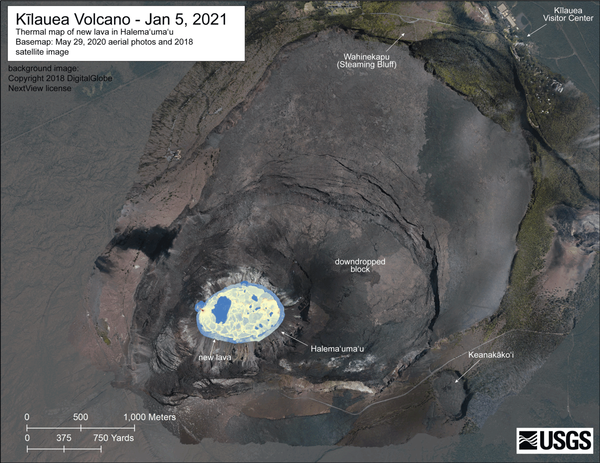
ANIMATED GIF: This animated image file (GIF) includes a series of thermal maps—ranging from daily to several weeks apart—made from helicopter overflight thermal imagery of Halema‘uma‘u crater, Kīlauea summit. The set of thermal maps are in a continuous loop showing the lava lake changes throughout the eruption.
Images
Volcano Hazard Program images.
Filter Total Items: 6274
Kīlauea Volcano summit eruption — thermal map GIF
ANIMATED GIF: This animated image file (GIF) includes a series of thermal maps—ranging from daily to several weeks apart—made from helicopter overflight thermal imagery of Halema‘uma‘u crater, Kīlauea summit. The set of thermal maps are in a continuous loop showing the lava lake changes throughout the eruption.

March 4 overflight of Kīlauea summit and East Rift Zone
March 4 overflight of Kīlauea summit and East Rift ZoneHVO's overflight today also included KILAUEA's lower East Rift Zone, where geologists continue to document and map the 2018 eruption deposits. Fissure 8, visible in the center of this photo, emits steam as this geologically-young feature continues to cool.

March 4 overflight of Kīlauea summit and East Rift Zone
March 4 overflight of Kīlauea summit and East Rift ZoneIn this view of Kīlauea Volcano's south caldera area, the margin of the 1982 lava flows are visible (right), as is a portion of Crater Rim Drive. During World War II, bulldozers were used to create mounds in an effort to prevent planes from landing in this area of Kīlauea.

March 4 overflight of Kīlauea summit and East Rift Zone
March 4 overflight of Kīlauea summit and East Rift ZoneThe fissure 8 lava flows of Kīlauea's 2018 lower East Rift Zone eruption meet the ocean at Pohoiki Bay, in the lower left corner of this image. Wave erosion of the 2018 lava flows along the coast contributes to sand accumulation that forms a beach at Pohoiki Bay. USGS image by K. Mulliken on March 4, 2021.

March 4 overflight of Kīlauea summit and East Rift Zone
March 4 overflight of Kīlauea summit and East Rift ZoneDuring the overflight of Kīlauea's lower East Rift Zone on March 4, HVO scientists documented different lava textures in the fissure 8 flow field that formed during the 2018 lower East Rift Zone eruption. This photo shows an area of fissure 8 flows near the ocean. Both rubbly ‘a‘ā (brownish black) and smooth pāhoehoe (grey) are visible. USGS image by K.

Halema‘uma‘u eruption sequence Digital Elevation Models
Halema‘uma‘u eruption sequence Digital Elevation ModelsHVO uses regular Kīlauea summit helicopter overflights of Halema‘uma‘u crater to create digital elevation models (DEMs) of the crater. The DEMs show changes in the crater over time and can be used to estimate erupted volume, eruption rate, and map features of interest.

View of lava lake in Halema‘uma‘u — Kīlauea, March 4 2021
View of lava lake in Halema‘uma‘u — Kīlauea, March 4 2021View of the lava lake from the west rim of Halema‘uma‘u, at the summit of Kīlauea, looking east. There is a small incandescent opening at the top of the west vent spatter cone (bottom-center). Volcanic gas emissions from the active west vent and are being transported to the southwest (bottom-right) by the wind.

March 4 overflight of Kīlauea summit and East Rift Zone
March 4 overflight of Kīlauea summit and East Rift ZoneHVO scientists conducted an overflight of Kīlauea's summit the morning of March 4 to document the ongoing eruption. No significant changes were observed—the vent in the northwest wall of Halema‘uma‘u continues to erupt and lava continues to slowly fill the crater.

March 4 overflight of Kīlauea summit and East Rift Zone
March 4 overflight of Kīlauea summit and East Rift ZoneSubtle steaming was visible at Pu‘u ‘Ō‘ō during HVO's overflight of Kīlauea on March 4, 2021. Steam is normally visible as the vent—which was active for more than 35 years—continues to cool, following the 2018 Pu‘u ‘Ō‘ō collapse.

Lava Lake Depth March 4th
Data from a Kīlauea summit helicopter overflight on March 4th allowed for the calculation of the depth of the lava in Halema‘uma‘u crater. The deepest parts of the lake (darkest reds) exceed 200 meters (650 feet). Different-colored lines in Halema‘uma‘u show the perimeter of the lava lake and the vents over the course of the eruption.
Data from a Kīlauea summit helicopter overflight on March 4th allowed for the calculation of the depth of the lava in Halema‘uma‘u crater. The deepest parts of the lake (darkest reds) exceed 200 meters (650 feet). Different-colored lines in Halema‘uma‘u show the perimeter of the lava lake and the vents over the course of the eruption.

Wide-angle view of Pu‘u ‘Ō‘ō, March 4, 2021
During a routine overflight of the Kīlauea East Rift Zone on March 4, HVO scientists visited the Pu‘u ‘Ō‘ō area to check for any significant changes in recent months. Their most notable observation was further accumulation of talus—rock collapse debris—in the crater that formed on April 30, 2018, as seen in this wide-angle photo.
During a routine overflight of the Kīlauea East Rift Zone on March 4, HVO scientists visited the Pu‘u ‘Ō‘ō area to check for any significant changes in recent months. Their most notable observation was further accumulation of talus—rock collapse debris—in the crater that formed on April 30, 2018, as seen in this wide-angle photo.

View of lava lake in Halema‘uma‘u - Kīlauea, March 4 2021
View of lava lake in Halema‘uma‘u - Kīlauea, March 4 2021The lava lake in Halema‘uma‘u crater remains active. This view looking to the northwest on Wednesday, March 4, 2021, focuses on the active portion of the lake; the eastern stagnant portion is out of view to the right. Lava enters the lake at the base of the western vent spatter cone (left).

March 4 overflight of Kīlauea summit and East Rift Zone
March 4 overflight of Kīlauea summit and East Rift ZoneSteam was also visible in other portions of the 2018 eruption flow field, close to Kīlauea's East Rift Zone (bottom portion of image). As lava was flowing south towards the ocean in 2018, lava channels formed; these channels are visible as dark grey meandering lines in the image. Like water, lava flows along the path of least resistance downslope. USGS image by K.

March 4 overflight of Kīlauea summit and East Rift Zone
March 4 overflight of Kīlauea summit and East Rift ZoneAn aerial view of Pu‘u Pua‘i, Kīlauea Iki, and Kīlauea caldera. Though the eruption within Halema‘uma‘u isn't visible from this vantage point, the bluish-tinged plume of volcanic gasses is visible near the center of the photo.

Halema‘uma‘u lava lake, Kīlauea summit eruption—March 3, 2021
Halema‘uma‘u lava lake, Kīlauea summit eruption—March 3, 2021View of the Kīlauea summit lava lake taken from the west rim of Halema‘uma‘u at 12:21 p.m. HST on March 3, 2021. The western portion of the lava lake is active with lava being fed from the west vent. The eastern surface of the lava lake remains crusted over. SO2 emission rates are elevated at approximately 1000 t/d, as measured on March 3, 2021.

Halema‘uma‘u lava lake, Kīlauea summit eruption—March 3, 2021
Halema‘uma‘u lava lake, Kīlauea summit eruption—March 3, 2021The lava lake in Halema‘uma‘u crater, at the summit of Kīlauea, remains active. Lava is entering the lake at a small inlet along the western lake margin, at the site of the western fissure. Active surface lava remains limited to the western portion of the lake. Scattered crustal foundering and small overflows were present on Tuesday, March 2, 2021. USGS photo by M.

Halema‘uma‘u lava lake, Kīlauea summit eruption—March 3, 2021
Halema‘uma‘u lava lake, Kīlauea summit eruption—March 3, 2021The western fissure in Halema‘uma‘u remains active, with incandescence visible in two small vent openings. The northeastern incandescent vent opening (right) has a narrow, drained lava channel extending down the flank of the cone. USGS photo taken by M. Patrick on March 2, 2021.

Halema‘uma‘u lava lake, Kīlauea summit eruption—March 3, 2021
Halema‘uma‘u lava lake, Kīlauea summit eruption—March 3, 2021Another close-up view of the western fissure in Halema‘uma‘u, showing the incandescent lava upwelling at the inlet zone along the western lake margin. This photo was taken on March 2, 2021, in an area of Hawai‘i Volcanoes National Park that remains closed to the public due to safety reasons. USGS photo by M. Patrick.

Halema‘uma‘u lava lake, Kīlauea summit eruption—March 3, 2021
Halema‘uma‘u lava lake, Kīlauea summit eruption—March 3, 2021The eastern portion of the lava lake in Halema‘uma‘u remains solidified at the surface. Numerous islands, previously drifting in the lake currents, are now locked in place. The remnants of a section of Crater Rim Drive, from the 2018 summit collapse, is visible in the lower right corner of the photo. USGS photo taken by M. Patrick on March 2, 2021.

February 26, 2021 — Kīlauea
On the afternoon of Friday February 26, 2021, the active west side of the lava lake at Halema‘uma‘u, Kīlauea Volcano, Hawaii, had numerous surface breakouts and foundering crust amid vigorous steaming due to the heavy rainfall. This view is looking to the east from the west side of the crater.
On the afternoon of Friday February 26, 2021, the active west side of the lava lake at Halema‘uma‘u, Kīlauea Volcano, Hawaii, had numerous surface breakouts and foundering crust amid vigorous steaming due to the heavy rainfall. This view is looking to the east from the west side of the crater.

February 26, 2021—Kīlauea summit eruption contour map
February 26, 2021—Kīlauea summit eruption contour mapThis map of Halema‘uma‘u at the summit of Kīlauea shows 20 m (66 ft) contour lines (dark gray) that mark locations of equal elevation above sea level (asl). The map shows that the lava lake has filled 218 m (715 ft) of the crater, to an elevation of 735 m (2411 ft) asl since the eruption began at approximately 9:30 p.m. HST on December 20, 2020.