



As part of routine monitoring efforts, HVO gas scientists collected helium samples from fumaroles in the Sulphur Banks, or Ha‘akulamanu, area of Hawai‘i Volcanoes National Park on September 30, 2020. Helium can pass through the glass of typical gas sampling bottles, so copper tubing is necessary for the specialized sample.
Images
Volcano Hazard Program images.
Filter Total Items: 6294

HVO gas scientists collected helium samples
As part of routine monitoring efforts, HVO gas scientists collected helium samples from fumaroles in the Sulphur Banks, or Ha‘akulamanu, area of Hawai‘i Volcanoes National Park on September 30, 2020. Helium can pass through the glass of typical gas sampling bottles, so copper tubing is necessary for the specialized sample.

Close-up image of native sulfur crystals
A close-up image of native sulfur crystals that formed within fumaroles at the Sulphur Banks in Hawai‘i Volcanoes National Park. In addition to sulfur species and other gases, volcanoes emit water vapor. Here, some of the vapor has condensed to liquid water and formed droplets visible on the sulfur crystals. USGS photo by P. Nadeau.
A close-up image of native sulfur crystals that formed within fumaroles at the Sulphur Banks in Hawai‘i Volcanoes National Park. In addition to sulfur species and other gases, volcanoes emit water vapor. Here, some of the vapor has condensed to liquid water and formed droplets visible on the sulfur crystals. USGS photo by P. Nadeau.

Crystals of pure native sulfur at sites of degassing called fumaroles
Crystals of pure native sulfur at sites of degassing called fumarolesDifferent sulfur gases, including sulfur dioxide (SO2) and hydrogen sulfide (H2S), can react with each other to deposit crystals of pure native sulfur at sites of degassing called fumaroles. The crystals picture here formed within a Sulphur Banks area fumarole in Hawai‘i Volcanoes National Park. USGS photo by T. Elias.
Crystals of pure native sulfur at sites of degassing called fumaroles
Crystals of pure native sulfur at sites of degassing called fumarolesDifferent sulfur gases, including sulfur dioxide (SO2) and hydrogen sulfide (H2S), can react with each other to deposit crystals of pure native sulfur at sites of degassing called fumaroles. The crystals picture here formed within a Sulphur Banks area fumarole in Hawai‘i Volcanoes National Park. USGS photo by T. Elias.

Tubing inserted into a fumarole
Tubing inserted into a fumarole at the Sulphur Banks in Hawai‘i Volcanoes National Park allows HVO gas scientists to sample gas. The gas travels through the tube into gas sampling bottles for later analyses. USGS photo by M. Warren.
Tubing inserted into a fumarole at the Sulphur Banks in Hawai‘i Volcanoes National Park allows HVO gas scientists to sample gas. The gas travels through the tube into gas sampling bottles for later analyses. USGS photo by M. Warren.

New seismic/GPS station (LSON) installed at Mount Hood
New seismic/GPS station (LSON) installed at Mount HoodUSGS Cascades Volcano Observatory Geophysicist Wes Thelen, removes ropes from new station LSON, at Mount Hood (Mount Hood is pictured in the distance).
New seismic/GPS station (LSON) installed at Mount Hood
New seismic/GPS station (LSON) installed at Mount HoodUSGS Cascades Volcano Observatory Geophysicist Wes Thelen, removes ropes from new station LSON, at Mount Hood (Mount Hood is pictured in the distance).

Installation of GPS mast at station BRSP on Mount Hood
Installation of GPS mast at station BRSP on Mount HoodUSGS Cascades Volcano Observatory Geophysicist Emily Montgomery-Brown uses a drill to create a small hole in volcanic rock that will support a GPS mast. The effort was part of a three-station installation project at Mount Hood in 2020. This station location is called BRSP.
Installation of GPS mast at station BRSP on Mount Hood
Installation of GPS mast at station BRSP on Mount HoodUSGS Cascades Volcano Observatory Geophysicist Emily Montgomery-Brown uses a drill to create a small hole in volcanic rock that will support a GPS mast. The effort was part of a three-station installation project at Mount Hood in 2020. This station location is called BRSP.

Helicopter delivers equipment to station BRSP on Mount Hood
Helicopter delivers equipment to station BRSP on Mount HoodA USGS Cascades Volcano Observatory field team waits on this remote north flank of Mount Hood, as a helicopter delivers supplies and equipment to station BRSP. The station was installed with minimal impact on the environment. A helicopter delivered equipment via external sling load and USGS personnel accessed the site by foot.
Helicopter delivers equipment to station BRSP on Mount Hood
Helicopter delivers equipment to station BRSP on Mount HoodA USGS Cascades Volcano Observatory field team waits on this remote north flank of Mount Hood, as a helicopter delivers supplies and equipment to station BRSP. The station was installed with minimal impact on the environment. A helicopter delivered equipment via external sling load and USGS personnel accessed the site by foot.

Installing a seismometer at station BRSP on Mount Hood
Installing a seismometer at station BRSP on Mount HoodVolcano Disaster Assistance Program Geophysicist Jeremy Pesicek digs a hole for a seismometer at station BRSP, on the north flank of Mount Hood. The seismometer, which detects earthquakes, is buried at a depth of at least 1 meter (3 feet).
Installing a seismometer at station BRSP on Mount Hood
Installing a seismometer at station BRSP on Mount HoodVolcano Disaster Assistance Program Geophysicist Jeremy Pesicek digs a hole for a seismometer at station BRSP, on the north flank of Mount Hood. The seismometer, which detects earthquakes, is buried at a depth of at least 1 meter (3 feet).

Panoramic view of Pocket Basin, Yellowstone National Park
Panoramic view of Pocket Basin, Yellowstone National ParkPanoramic photo of Pocket Basin, a hydrothermal explosion crater in Yellowstone National Park's Lower Geyser Basin, taken from the northeast rim looking southwest into the crater. Pocket Basin is a U-shaped crater that is dissected on the SW edge by the Firehole River, visible on the far-right of the photo.
Panoramic view of Pocket Basin, Yellowstone National Park
Panoramic view of Pocket Basin, Yellowstone National ParkPanoramic photo of Pocket Basin, a hydrothermal explosion crater in Yellowstone National Park's Lower Geyser Basin, taken from the northeast rim looking southwest into the crater. Pocket Basin is a U-shaped crater that is dissected on the SW edge by the Firehole River, visible on the far-right of the photo.

Wahinekapu (Steaming Bluff) and the Steam Vents area
Wahinekapu (Steaming Bluff) and the Steam Vents areaThe weather was overcast during an overflight of Kīlauea's summit on September 23, 2020. This view shows Wahinekapu (Steaming Bluff) and the Steam Vents area within Hawai‘i Volcanoes National Park. Extensive cracks in the area allow heated groundwater to escape from underground.
Wahinekapu (Steaming Bluff) and the Steam Vents area
Wahinekapu (Steaming Bluff) and the Steam Vents areaThe weather was overcast during an overflight of Kīlauea's summit on September 23, 2020. This view shows Wahinekapu (Steaming Bluff) and the Steam Vents area within Hawai‘i Volcanoes National Park. Extensive cracks in the area allow heated groundwater to escape from underground.

Kīlauea summit gravity survey - September 23, 2020
Kīlauea summit gravity survey - September 23, 2020On September 23, 2020, Hawaiian Volcano Observatory geophysicists and a geologist conducted a gravity survey of Kīlauea summit, as part of HVO's regular monitoring program. In this photo, scientists are carrying survey equipment westward along the remnants of the Halema‘uma‘u Trail on the down-dropped block of Kīlauea caldera.
Kīlauea summit gravity survey - September 23, 2020
Kīlauea summit gravity survey - September 23, 2020On September 23, 2020, Hawaiian Volcano Observatory geophysicists and a geologist conducted a gravity survey of Kīlauea summit, as part of HVO's regular monitoring program. In this photo, scientists are carrying survey equipment westward along the remnants of the Halema‘uma‘u Trail on the down-dropped block of Kīlauea caldera.

Kīlauea summit gravity survey - September 23, 2020
Kīlauea summit gravity survey - September 23, 2020A gravimeter makes a measurement at a benchmark situated among lava flows erupted in 1919. The strength of gravity varies with both elevation and the amount of mass beneath the instrument. Changes in mass can indicate changes in the amount of magma entering Kīlauea's magma reservoirs. USGS photo by A. Flinders.
Kīlauea summit gravity survey - September 23, 2020
Kīlauea summit gravity survey - September 23, 2020A gravimeter makes a measurement at a benchmark situated among lava flows erupted in 1919. The strength of gravity varies with both elevation and the amount of mass beneath the instrument. Changes in mass can indicate changes in the amount of magma entering Kīlauea's magma reservoirs. USGS photo by A. Flinders.
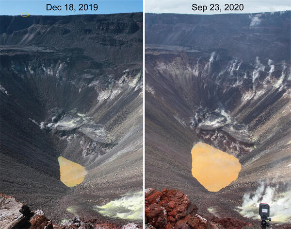
Kīlauea's summit water lake comparison - September 23, 2020
Kīlauea's summit water lake comparison - September 23, 2020HVO geologists made observations of Kīlauea's summit water lake from the east rim of Halema‘uma‘u. This view point is on the large downdropped block that subsided during the 2018 collapse events. From this spot, a view of the entire lake is possible, providing a new perspective on the growth of the lake.
Kīlauea's summit water lake comparison - September 23, 2020
Kīlauea's summit water lake comparison - September 23, 2020HVO geologists made observations of Kīlauea's summit water lake from the east rim of Halema‘uma‘u. This view point is on the large downdropped block that subsided during the 2018 collapse events. From this spot, a view of the entire lake is possible, providing a new perspective on the growth of the lake.

Kīlauea's water lake from the east side - September 23, 2020
Kīlauea's water lake from the east side - September 23, 2020This view shows Kīlauea's water lake from the east side of the crater. On September 23, 2020, the western portion of the lake (top of image) was the most varied in color, with patches of greenish and brown water. The majority of the lake surface, however, was the typical tan hue. USGS photo by M. Patrick.
Kīlauea's water lake from the east side - September 23, 2020
Kīlauea's water lake from the east side - September 23, 2020This view shows Kīlauea's water lake from the east side of the crater. On September 23, 2020, the western portion of the lake (top of image) was the most varied in color, with patches of greenish and brown water. The majority of the lake surface, however, was the typical tan hue. USGS photo by M. Patrick.

Floating material on Kīlauea's summit water lake on September 23, 2020
Floating material on Kīlauea's summit water lake on September 23, 2020Small patches of light-colored floating material were seen drifting on the surface of Kīlauea's summit water lake on September 23, 2020. The composition of this material is unknown, but future water sampling missions may provide insight. USGS photo by M. Patrick.
Floating material on Kīlauea's summit water lake on September 23, 2020
Floating material on Kīlauea's summit water lake on September 23, 2020Small patches of light-colored floating material were seen drifting on the surface of Kīlauea's summit water lake on September 23, 2020. The composition of this material is unknown, but future water sampling missions may provide insight. USGS photo by M. Patrick.

Kīlauea’s summit water lake and Crater Rim Drive - September 23, 2020
Kīlauea’s summit water lake and Crater Rim Drive - September 23, 2020Portions of Crater Rim Drive, within Hawai‘i Volcanoes National Park, appear cracked, offset, and down-dropped in this photo, taken during an overflight of Kīlauea’s summit on September 23, 2020. To the north, Kīlauea’s summit water lake, within Halema‘uma‘u, is visible. USGS photo by K. Mulliken.
Kīlauea’s summit water lake and Crater Rim Drive - September 23, 2020
Kīlauea’s summit water lake and Crater Rim Drive - September 23, 2020Portions of Crater Rim Drive, within Hawai‘i Volcanoes National Park, appear cracked, offset, and down-dropped in this photo, taken during an overflight of Kīlauea’s summit on September 23, 2020. To the north, Kīlauea’s summit water lake, within Halema‘uma‘u, is visible. USGS photo by K. Mulliken.

Sulphur Banks area and Ha‘akulamanu trail
Hawaiian Volcano Observatory geologists flew over the Sulphur Banks area and Ha‘akulamanu trail within Hawai‘i Volcanoes National Park on September 23, 2020. Fumaroles in the Sulphur Banks area are sampled approximately every three months by Hawaiian Volcano Observatory gas geochemists to track long-term changes in volcanic gas chemistry at Kīlauea.
Hawaiian Volcano Observatory geologists flew over the Sulphur Banks area and Ha‘akulamanu trail within Hawai‘i Volcanoes National Park on September 23, 2020. Fumaroles in the Sulphur Banks area are sampled approximately every three months by Hawaiian Volcano Observatory gas geochemists to track long-term changes in volcanic gas chemistry at Kīlauea.

Kīlauea summit gravity survey - September 23, 2020
Kīlauea summit gravity survey - September 23, 2020During a gravity survey, HVO scientists measure the relative strength of gravity (gravimeter, bottom left corner of photo) between benchmarks. High-precision vertical positions from kinematic Global Positioning System (GPS, tripod and antenna middle of photo) help correct the gravity measurement for the effects of elevation changes.
Kīlauea summit gravity survey - September 23, 2020
Kīlauea summit gravity survey - September 23, 2020During a gravity survey, HVO scientists measure the relative strength of gravity (gravimeter, bottom left corner of photo) between benchmarks. High-precision vertical positions from kinematic Global Positioning System (GPS, tripod and antenna middle of photo) help correct the gravity measurement for the effects of elevation changes.

Kīlauea summit gravity survey - September 23, 2020
Kīlauea summit gravity survey - September 23, 2020An HVO geophysicist takes a gravity measurement at a benchmark near a continuous gravimeter (inside hutch). The continuous gravimeter takes gravity measurements once per second and relays the data via radio back to HVO. During the gravity survey on September 23, 2020, HVO scientists took measurements at multiple locations on the floor of Kīlauea caldera.
Kīlauea summit gravity survey - September 23, 2020
Kīlauea summit gravity survey - September 23, 2020An HVO geophysicist takes a gravity measurement at a benchmark near a continuous gravimeter (inside hutch). The continuous gravimeter takes gravity measurements once per second and relays the data via radio back to HVO. During the gravity survey on September 23, 2020, HVO scientists took measurements at multiple locations on the floor of Kīlauea caldera.

Color variations at Kīlauea's summit water lake - 09/18/2020
Color variations at Kīlauea's summit water lake - 09/18/2020Color variations are common at Kīlauea's summit water lake, and are usually dominated by tan and brown hues. Today, the interaction between different color zones produced a large swirl in the center of the lake.
Color variations at Kīlauea's summit water lake - 09/18/2020
Color variations at Kīlauea's summit water lake - 09/18/2020Color variations are common at Kīlauea's summit water lake, and are usually dominated by tan and brown hues. Today, the interaction between different color zones produced a large swirl in the center of the lake.

Map of the USGS Hawaiian Volcano Observatory’s current camera network
Map of the USGS Hawaiian Volcano Observatory’s current camera networkMap of the USGS Hawaiian Volcano Observatory’s current camera network coverage. Lava-flow hazard zone 1 is outlined in yellow. Color-shaded areas are visible to at least one camera in the current network. We would like to expand the network so that it covers the grey-shaded areas in zone 1 as well. If your property has a good view
Map of the USGS Hawaiian Volcano Observatory’s current camera network
Map of the USGS Hawaiian Volcano Observatory’s current camera networkMap of the USGS Hawaiian Volcano Observatory’s current camera network coverage. Lava-flow hazard zone 1 is outlined in yellow. Color-shaded areas are visible to at least one camera in the current network. We would like to expand the network so that it covers the grey-shaded areas in zone 1 as well. If your property has a good view