
USGS personnel on the deck of the R/V Hugh R.
Images
Coastal and Marine Hazards and Resources Program images.
Filter Total Items: 2413

Retrieving Seismic Airguns
USGS personnel on the deck of the R/V Hugh R.

Dead elkhorn coral at Buck Island Reef National Monument, St. Croix, U.S. Virgin Islands
Dead elkhorn coral at Buck Island Reef National Monument, St. Croix, U.S. Virgin IslandsPhoto shows a dead, relict reef framework built by the elkhorn coral, Acropora palmata in Buck Island Reef National Monument, St. Croix, U.S. Virgin Islands.

Photograph of the entrance to Grand Traverse Bay Harbor
Photograph of the entrance to Grand Traverse Bay HarborPhotograph of the entrance to Grand Traverse Bay Harbor, located 8 kilometers downdrift of the spoils pile. Migration of the dark-colored stamp sands (moving from left to right) has buried the original beach, overtopped the wall, and partially blocked the channel.

Photograph showing a high scarp cut into the large pile of stamp sands
Photograph showing a high scarp cut into the large pile of stamp sandsPhotograph showing a high scarp cut into the large pile of stamp sands at the town of Gay, Michigan. Nearly a century of erosion by waves and currents has transported millions of cubic yards of mine tailings along the coast and spread them across the adjacent lake floor.

Photograph of the R/V Rafael alongside dock near the survey site
Photograph of the R/V Rafael alongside dock near the survey sitePhotograph of the R/V Rafael alongside dock near the survey site on Lake Superior.
Photograph of the R/V Rafael alongside dock near the survey site
Photograph of the R/V Rafael alongside dock near the survey sitePhotograph of the R/V Rafael alongside dock near the survey site on Lake Superior.

An egret walks in the surf of Dauphin Island beach
An egret walks in the surf of Dauphin Island beachAn egret walks in the shallow surf of an undeveloped beach on Dauphin Island, Alabama, with buildings viewed in the background from a different area on the island.
An egret walks in the surf of Dauphin Island beach
An egret walks in the surf of Dauphin Island beachAn egret walks in the shallow surf of an undeveloped beach on Dauphin Island, Alabama, with buildings viewed in the background from a different area on the island.

Erosion has taken a toll on this Keys coral
A reef in the Florida Keys National Marine Sanctuary with little living coral and extensive bioerosion. Photo taken under research permit number FKNMS-2016-085-A1. Credit: USGS, Ilsa Kuffner.
A reef in the Florida Keys National Marine Sanctuary with little living coral and extensive bioerosion. Photo taken under research permit number FKNMS-2016-085-A1. Credit: USGS, Ilsa Kuffner.

Atlantic Spotted Dolphins
Atlantic spotted dolphins photographed near the R/V Hugh R. Sharp on August 27, 2018 by the protected species visual observers.
Atlantic spotted dolphins photographed near the R/V Hugh R. Sharp on August 27, 2018 by the protected species visual observers.

Cover of California's Fourth Climate Change Assessment Report
Cover of California's Fourth Climate Change Assessment ReportCover of the 2018 publication, "California’s Fourth Climate Change Assessment: Statewide Summary Report."
Cover of California's Fourth Climate Change Assessment Report
Cover of California's Fourth Climate Change Assessment ReportCover of the 2018 publication, "California’s Fourth Climate Change Assessment: Statewide Summary Report."

View of Unalakleet from the air
Unalakleet village on the low-lying barrier spit at the inlet of the Unalakleet River and Norton Sound, Alaska.
Unalakleet village on the low-lying barrier spit at the inlet of the Unalakleet River and Norton Sound, Alaska.
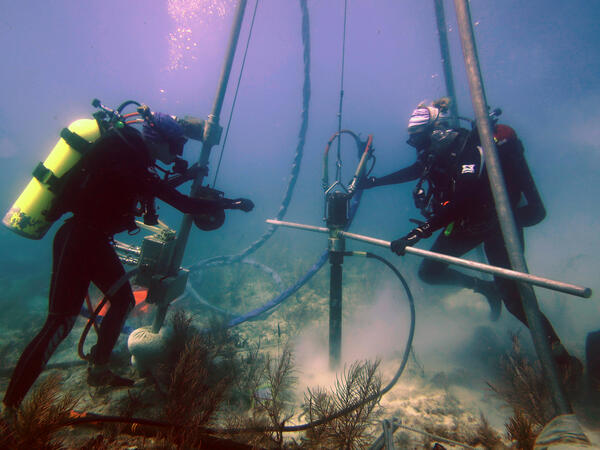
USGS scientists drill a coral-reef core in the Florida Keys
USGS scientists drill a coral-reef core in the Florida KeysResearch Oceanographer Lauren Toth and student volunteer Liz Whitcher drill a coral-reef core from a reef off Key West, Florida, in the Florida Keys National Marine Sanctuary. Photo taken under research permit FKNMS-2015-058. Credit: Anastasios Stathakopoulos, USGS.

Retrieving airguns
Jenny White McKee and Pete Dal Ferro of the Pacific Coastal and Marine Science Center retrieve two airguns during the 2018 MATRIX cruise aboard the R/V Hugh R. Sharp. The seismic streamer is visible on the winch in the foreground.
Jenny White McKee and Pete Dal Ferro of the Pacific Coastal and Marine Science Center retrieve two airguns during the 2018 MATRIX cruise aboard the R/V Hugh R. Sharp. The seismic streamer is visible on the winch in the foreground.

Diesel Compressors
Four diesel-powered compressors chained to the deck of the R/V Hugh R. Sharp provided the air to power the seismic sources during the MATRIX cruise.
Four diesel-powered compressors chained to the deck of the R/V Hugh R. Sharp provided the air to power the seismic sources during the MATRIX cruise.

Deploying two seismic sources
Jenny McKee and Peter Dal Farro of the USGS Pacific Coastal and Marine Science Center swing a pair of seismic sources, also called air guns, and the gun hanger, out over the water to deploy them during the 2018 MATRIX cruise. Scripps Institution of Oceanography's seismic streamer is coiled on the blue winch in the foreground.
Jenny McKee and Peter Dal Farro of the USGS Pacific Coastal and Marine Science Center swing a pair of seismic sources, also called air guns, and the gun hanger, out over the water to deploy them during the 2018 MATRIX cruise. Scripps Institution of Oceanography's seismic streamer is coiled on the blue winch in the foreground.

Drone Demos at 2018 Woods Hole, MA Science Stroll
USGS drone demonstration at the 2018 Woods Hole, MA Science Stroll
USGS drone demonstration at the 2018 Woods Hole, MA Science Stroll

Woods Hole Science Stroll 2018
Woods Hole Coastal and Marine Science Center staff, Tarandeep Kalra (pointing in light blue shirt) and Zafer Defne (orange USGS shirt) discuss oceanographic models with Science Stroll attendees
Woods Hole Coastal and Marine Science Center staff, Tarandeep Kalra (pointing in light blue shirt) and Zafer Defne (orange USGS shirt) discuss oceanographic models with Science Stroll attendees

Drone Demos at 2018 Woods Hole, MA Science Stroll
2018 Woods Hole, MA Science Stroll USGS drone demonstration
2018 Woods Hole, MA Science Stroll USGS drone demonstration

Future Pilots!
Sandy Brosnahan, Woods Hole Coastal and Marine Science Center's Aerial Imaging and Mapping project lead, shares the display screen of a drone in flight
Sandy Brosnahan, Woods Hole Coastal and Marine Science Center's Aerial Imaging and Mapping project lead, shares the display screen of a drone in flight

2018 Woods Hole Science Stroll UAS Demo
Woods Hole Coastal and Marine Science Center Unmanned Aerial Systems (UAS) demonstration, 2018 Woods Hole Science Stroll
Woods Hole Coastal and Marine Science Center Unmanned Aerial Systems (UAS) demonstration, 2018 Woods Hole Science Stroll

Sharing Science
Sandy Baldwin, Woods Hole Coastal and Marine Science Center, shares video from the kilauea volcano with Science Stroll participants.
Sandy Baldwin, Woods Hole Coastal and Marine Science Center, shares video from the kilauea volcano with Science Stroll participants.

USGS display table at the 2018 Woods Hole, MA Science Stroll
USGS display table at the 2018 Woods Hole, MA Science StrollUSGS display table at the 2018 Woods Hole, MA Science Stroll
USGS display table at the 2018 Woods Hole, MA Science Stroll
USGS display table at the 2018 Woods Hole, MA Science StrollUSGS display table at the 2018 Woods Hole, MA Science Stroll