
The Total Water Level and Coastal Change Forecast Viewer reflecting inundation data on the Gulf coast of Florida during Hurricane Milton.
Images
Coastal and Marine Hazards and Resources Program images.
Filter Total Items: 2399
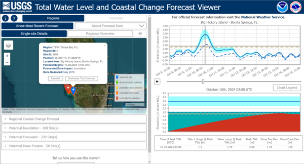
TWL - Hurricane Milton
The Total Water Level and Coastal Change Forecast Viewer reflecting inundation data on the Gulf coast of Florida during Hurricane Milton.
CCH Portal - Hurricane Milton
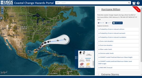
Coastal Change Hazards Portal showing the trajectory of Hurricane Milton and the various data users could explore on the map.
Coastal Change Hazards Portal showing the trajectory of Hurricane Milton and the various data users could explore on the map.
Flood Event Viewer - Hurricane Milton
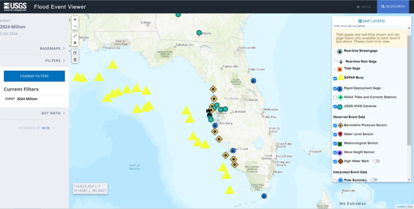
The Flood Event Viewer showing map data layers available during Hurricane Milton.
The Flood Event Viewer showing map data layers available during Hurricane Milton.
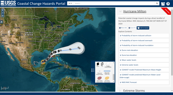
CCH Portal COAWST - Hurricane Milton
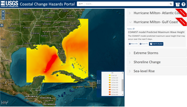
Coastal Change Hazards Portal showing maximum wave height and storm surge via the COAWST modeling system during Hurricane Milton.
Coastal Change Hazards Portal showing maximum wave height and storm surge via the COAWST modeling system during Hurricane Milton.
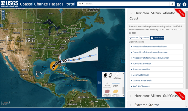
CCH Portal - Hurricane Milton
Coastal Change Hazards Portal showing the trajectory of Hurricane Milton and the various data users could explore on the map.
Coastal Change Hazards Portal showing the trajectory of Hurricane Milton and the various data users could explore on the map.
CCH Portal - Hurricane Milton
Coastal Change Hazards Portal showing the trajectory of Hurricane Milton and the various data users could explore on the map.
Coastal Change Hazards Portal showing the trajectory of Hurricane Milton and the various data users could explore on the map.

CoastCam - Hurricane Helene
CoastCam on Madeira Beach in Florida showing coastal conditions during the approach of Hurricane Helene on September 26, 2024.
CoastCam on Madeira Beach in Florida showing coastal conditions during the approach of Hurricane Helene on September 26, 2024.
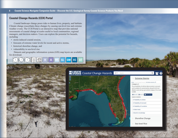
Companion Guide - CCH Portal page
Coastal Change Hazards Portal page of the Coastal Science Navigator Companion Guide.
Coastal Change Hazards Portal page of the Coastal Science Navigator Companion Guide.
Companion Guide
Screenshots from the Coastal Science Navigator Companion Guide overlaid on top of image of the Army Corps of Engineers Field Research Facility pier near Kitty Hawk, North Carolina.
Screenshots from the Coastal Science Navigator Companion Guide overlaid on top of image of the Army Corps of Engineers Field Research Facility pier near Kitty Hawk, North Carolina.
Icon Page
The Coastal Science Navigator Companion Guide introduces you to USGS coastal change hazards-related products—including interactive data maps, downloadable software, geonarratives, and more. It's organized by timescale, highlighting products relevant to the present, past, and future, although many cover multiple timescales.
The Coastal Science Navigator Companion Guide introduces you to USGS coastal change hazards-related products—including interactive data maps, downloadable software, geonarratives, and more. It's organized by timescale, highlighting products relevant to the present, past, and future, although many cover multiple timescales.

Companion Guide - CCL page
The Coastal Change Likelihood Website page of the Coastal Science Navigator Companion Guide.
The Coastal Change Likelihood Website page of the Coastal Science Navigator Companion Guide.

Companion Guide - U.S. Coastal Wetlands Synthesis
The U.S. Coastal Wetlands Synthesis page of the Coastal Science Navigator Companion Guide.
The U.S. Coastal Wetlands Synthesis page of the Coastal Science Navigator Companion Guide.

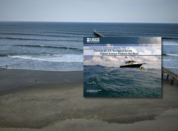
Companion Guide Cover
Cover of the Coastal Science Navigator Companion Guide. The guide introduces some of the many coastal change hazards-related products available through the USGS. In it, we showcase the products included in the Coastal Science Navigator’s initial publication in July 2023.
Cover of the Coastal Science Navigator Companion Guide. The guide introduces some of the many coastal change hazards-related products available through the USGS. In it, we showcase the products included in the Coastal Science Navigator’s initial publication in July 2023.

Coastal Change Hazards Team Forecasted Hurricane Francine Beach Impacts
Coastal Change Hazards Team Forecasted Hurricane Francine Beach ImpactsThe USGS Coastal Change Hazards Portal shows predictions for the coasts of Texas, Louisiana, and Mississippi from Hurricane Francine.
Coastal Change Hazards Team Forecasted Hurricane Francine Beach Impacts
Coastal Change Hazards Team Forecasted Hurricane Francine Beach ImpactsThe USGS Coastal Change Hazards Portal shows predictions for the coasts of Texas, Louisiana, and Mississippi from Hurricane Francine.

Donya Frank-Gilchrist presenting at the International Conference on Coastal Engineering
Donya Frank-Gilchrist presenting at the International Conference on Coastal EngineeringDr. Donya Frank-Gilchrist of the USGS St. Petersburg Coastal and Marine Science Center presented research on sediment transport in coastal regions at the International Conference on Coastal Engineering on 9/8-9/14/2024, in Rome, Italy.

Drs. Donya Frank-Gilchrist and Michael Itzkin giving presentations at ICCE
Drs. Donya Frank-Gilchrist and Michael Itzkin giving presentations at ICCEDrs. Donya Frank-Gilchrist and Michael Itzkin of the USGS St. Petersburg Coastal and Marine Science Center presented research on sediment transport in coastal regions at the International Conference on Coastal Engineering on 9/8-9/14/2024, in Rome, Italy.
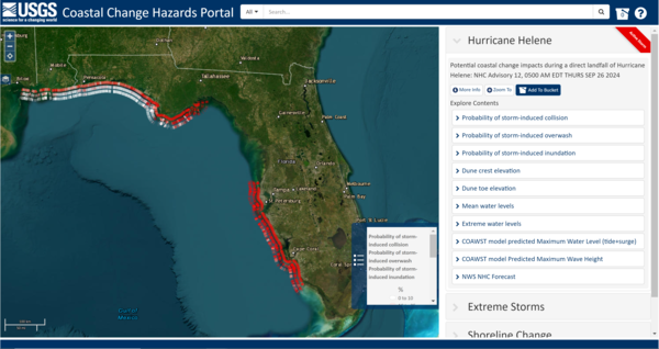
CCH Portal - Hurricane Helene
Coastal Change Hazards Portal showing the probability of storm-induced collision, overwash, and inundation during Hurricane Helene.
Coastal Change Hazards Portal showing the probability of storm-induced collision, overwash, and inundation during Hurricane Helene.
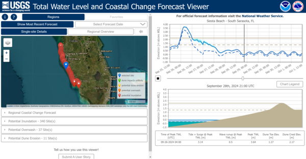
TWL - Hurricane Helene
The Total Water Level and Coastal Change Forecast Viewer reflecting inundation data on the Gulf coast of Florida during Hurricane Helene.
The Total Water Level and Coastal Change Forecast Viewer reflecting inundation data on the Gulf coast of Florida during Hurricane Helene.

Breakout Table 4 Discussion of the Mayagüez Session of the USGS Workshop in Puerto Rico Titled “Participatory Engagement for Storm Management”
Breakout Table 4 Discussion of the Mayagüez Session of the USGS Workshop in Puerto Rico Titled “Participatory Engagement for Storm Management”Breakout Table 4 Discussion of the Mayagüez Session of the USGS Workshop in Puerto Rico Titled “Participatory Engagement for Storm Management.”

Breakout Table 2 Discussion of the Mayagüez Session of the USGS Workshop in Puerto Rico Titled “Participatory Engagement for Storm Management”
Breakout Table 2 Discussion of the Mayagüez Session of the USGS Workshop in Puerto Rico Titled “Participatory Engagement for Storm Management”Breakout Table 2 Discussion of the Mayagüez Session of the USGS Workshop in Puerto Rico Titled “Participatory Engagement for Storm Management.”

Breakout Table 3 Discussion of the Mayagüez Session of the USGS Workshop in Puerto Rico Titled “Participatory Engagement for Storm Management”
Breakout Table 3 Discussion of the Mayagüez Session of the USGS Workshop in Puerto Rico Titled “Participatory Engagement for Storm Management”Breakout Table 3 Discussion of the Mayagüez Session of the USGS Workshop in Puerto Rico Titled “Participatory Engagement for Storm Management”