Search Earthquake Catalog
online search by time window, area, magnitude, and more
online search by time window, area, magnitude, and more
2025 USGS and ANSS Earthquake Monitoring Report
A geonarrative exploring domestic and global earthquake monitoring efforts in 2025
A geonarrative exploring domestic and global earthquake monitoring efforts in 2025
Significant Earthquakes, Past 30 days
Significant Earthquakes, Past 30 days
5.2
19 km SE of Silver Springs, Nevada
2026-05-01 08:17:20 (UTC)
Pager Alert Level: Green
MMI: VI (Strong Shaking)
5.0 km
4.0
1 km WNW of Cooter, Missouri
2026-04-23 17:59:04 (UTC)
Pager Alert Level: Green
MMI: IV (Light Shaking)
11.8 km
4.8
19 km SE of Silver Springs, Nevada
2026-04-22 17:23:37 (UTC)
Pager Alert Level: Green
MMI: VI (Strong Shaking)
3.0 km
7.4
100 km ENE of Miyako, Japan
2026-04-20 07:53:00 (UTC)
Pager Alert Level: Green
MMI: VI (Strong Shaking)
35.0 km
5.7
20 km ESE of Silver Springs, Nevada
2026-04-14 01:29:12 (UTC)
Pager Alert Level: Green
MMI: VII (Very Strong Shaking)
5.0 km
Earthquake Hazards Program
The USGS monitors and reports on earthquakes, assesses earthquake impacts and hazards, and conducts targeted research on the causes and effects of earthquakes. We undertake these activities as part of the larger National Earthquake Hazards Reduction Program (NEHRP), a four-agency partnership established by Congress.
Latest Earthquakes
Latest Earthquakes

Latest earthquakes map and list (past 24 hours, M2.5+) from the ANSS (Advanced National Seismic System).
Search Earthquake Catalog
Search Earthquake Catalog

Find an earthquake or a list of earthquakes by time window, magnitude, area, and more, and choose the output format - map and list, CVS, and others.
News
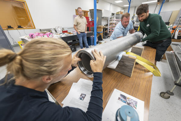
The Loneliest Seismometers on Earth
The Loneliest Seismometers on Earth
Updates for ShakeAlert False Alert for M5.9 Earthquake near Carson City, NV (Dec. 2025)
Updates for ShakeAlert False Alert for M5.9 Earthquake near Carson City, NV (Dec. 2025)
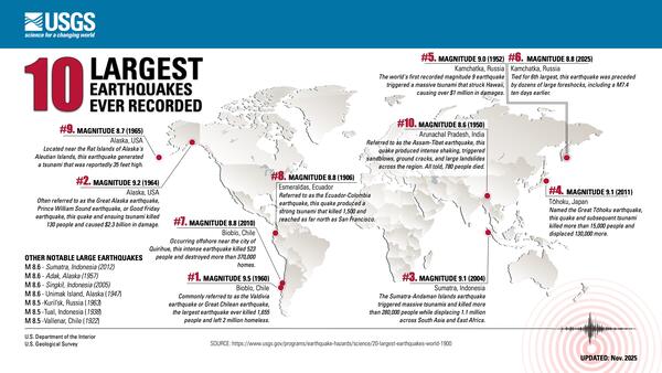
USGS releases aftershock forecast for M8.8 Russian Kamchatka Peninsula Earthquake
USGS releases aftershock forecast for M8.8 Russian Kamchatka Peninsula Earthquake
Publications
Compact seismicity bursts have different characteristics from regional seismicity Compact seismicity bursts have different characteristics from regional seismicity
Earthquakes tend to cluster, developing into sequences driven by stress perturbations and transient fault-zone processes. Depending on the driving process, earthquake sequences show differing behaviors. This variability challenges our ability to observe or distinguish these driving processes in high resolution. Here we systematically identify seismicity bursts throughout southern...
Constraining source and path effects of large magnitude earthquakes using ground motion simulations Constraining source and path effects of large magnitude earthquakes using ground motion simulations
The purpose of this study is to use ground‐motion simulations to investigate ways in which source and path effects for large‐magnitude earthquakes can be represented in nonergodic ground‐motion models (GMMs). To achieve this, we designed a ground‐motion study in the San Francisco Bay Area that includes earthquakes with a broad range of magnitudes distributed uniformly on a fault plane...
Science

Geologic Mapping for Landscape Resiliency in California, Oregon, and Washington
This project uses geologic and geomorphic mapping in the context of societally relevant problems in the Earth’s critical zone. Leveraging interdisciplinary research ties and interagency collaborations, it utilizes remote sensing data, corroborated with field observations, to determine i) the spatial distribution of geomorphic processes and ages of Quaternary deposits in the context of active...
By
Earthquake Hazards Program, Landslide Hazards Program, National Cooperative Geologic Mapping Program, Earthquake Science Center, Geologic Hazards Science Center, Geology, Minerals, Energy, and Geophysics Science Center, Geosciences and Environmental Change Science Center, Pacific Coastal and Marine Science Center, Big Sur Landslides

Mapping the grid: The United States Magnetotelluric Array
The United States has been mapped from space to the ground across its surface; however never from the perspective of the planet’s own electrical heartbeat. Over nearly two decades, the United States Magnetotelluric Array quietly marched across the country, station by station, building the first-ever electrical portrait of the crust and upper mantle beneath the contiguous U.S. An ambitious, multi...
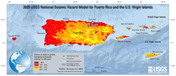
2025 PRVI NSHM Rollout & User-Needs Meeting
In conjunction with publication of the 2025 Puerto Rico and U.S. Virgin Islands (PRVI) National Seismic Hazard Model (NSHM), the USGS National Seismic Hazard Model Project (NSHMP) will host a one-day public meeting in San Juan, Puerto Rico. Additional meeting information, including a link to the registration form, is provided below.