
Research Enhancing Park Recreation and Tourism
Scientists from the USGS Ecosystems Land Change Science Program work hand-in-hand with park managers to support abundant and enduring outdoor recreation and tourism opportunities in the Nation’s national parks.
USGS science plays a key role in supporting the economic and other benefits of outdoor recreation and tourism on public lands, which depend on productive lands and waters abundant with fish and wildlife.
USGS scientists work with park managers to make high quality natural resource management decisions, ensuring these destinations continue to support outdoor recreation and tourism for generations to come.
Learn more about how the Land Change Science Program in the USGS Ecosystems Mission Area supports outdoor recreation and tourism in our national parks.
Supporting Recreation Operations in Glacier
In Glacier National Park, park managers rely on USGS expertise at Northern Rocky Mountain Science Center to provide on-site avalanche forecasting and place-based research for the Going-to-the-Sun Road – a major thoroughfare and tourist destination in the park.
Since the USGS Glacier National Park Avalanche Program began forecasting efforts in 2003, there have been no avalanche related injuries or fatalities, despite there being 1168 avalanche days with 607 avalanches that impacted the road over the 22-year period.
Further, in 2021, due to increased park visitation by tourists and access to higher stretches of road, USGS began providing weekend avalanche forecasts to the Visitor Protection Division at Glacier National Park, which uses those forecasts as the definitive measure of whether to close specific areas for public safety, saving lives and property.

Protecting Fragile Cultural and Paleontologic Resources in the Southwest
USGS science is used by National Park Service managers to make decisions regarding the protection and interpretation of fragile, non-renewable cultural and paleotonologic resources – such as ancient human footprints, megafaunal tracks, and vertebrate fossils. USGS scientists at the Geoscience and Environmental Change Science Center have been at the forefront of investigations leading to the discovery of these resources in the parks.
These resources draw recreationists to parks in the southwestern U.S., including Tule Springs Fossil Beds National Monument, White Sands National Park, Death Valley National Park, Grand Canyon National Park, Joshua Tree National Park, and Channel Islands National Park.

Protecting Park Infrastructure along the Gulf and Atlantic Coasts
Along the Gulf of America and Atlantic coasts, national parks and preserves are vulnerable to sea-level rise, which threatens to inundate irreplaceable historic buildings, archeological sites, and other infrastructure located in low-lying areas.
USGS scientists at the Wetland and Aquatic Research Center partnered with the National Park Service to develop maps projecting future sea-level rise for federally managed units in the region. They also published a series of USGS Fact Sheets about projected sea-level rise and high tide flooding at six parks in the region, in collaboration with their partners.
National Park Service and other federal land managers are using this information to inform park infrastructure and resource plans.

Managing Drylands for Recreation on the Colorado Plateau
Many drylands in the west are managed for recreation and domestic livestock grazing, which generates billions of dollars of revenue for the federal government and contributes hundreds of millions of dollars to local communities.
USGS scientists at Southwest Biological Science Center work with public land managers and ranchers to develop strategies to help avoid the most deleterious impacts of drought and invasives through management and restoration.
For example, USGS is working with National Park Service to test new restoration techniques to address drought-driven land degradation in Canyonlands and Arches National Parks, which together welcomed over 1.5 million visitors in 2024. The USGS is also working with ranchers and partners to test livestock breeds and management techniques that may help mitigate impacts of drought on ranchers and rangelands.

Providing Scientific Information on Glacier National Park’s Namesake
Visitors to Glacier National Park want to know about the status of its namesake glaciers. USGS glaciologists at the Northern Rocky Mountain Science Center work with the park to deliver this information. Using a combination of remote sensing and field campaigns, USGS conducts research that quantifies and elucidates glacier change.
USGS data derived from historic maps and geologic interpretation of modern satellite imagery document glacier changes from the mid-19th century to the modern era. Starting in 2005, the USGS Benchmark Glacier Project has collected direct measurements of glacier mass balance on Sperry Glacier.

Preserving an Iconic Landscape in Rocky Mountain
In Rocky Mountain National Park, resource managers rely on USGS research and monitoring data on alpine and subalpine lakes to understand how these iconic ecosystems are impacted by disturbances, like atmospheric nitrogen deposition, and how to preserve them for future generations.
The research partnership between USGS scientists at Fort Collins Science Center and the park began in the 1980s and has been ongoing for 40+ years. As a result of USGS research, NPS, EPA, and the State of Colorado created a voluntary Nitrogen Deposition Reduction Plan with the goal of reducing nitrogen pollution to protect Rocky Mountain National Park resources through voluntary collaboration and emissions reduction with stakeholders.

Understanding Recreational Resources that Enrich Visitor Experience at Dinosaur National Monument
Park managers at Dinosaur National Monument are tasked with planning for future environmental changes that impact the cultural, natural, and recreational resources at the park. One aspect of future readiness is documenting unique resources there, such as Ponderosa pine growing on the meander benches of the Green and Yampa Rivers that traverse the park. These rivers are iconic destinations for commercial and private boating.
USGS science is providing the expertise to document the natural history of streamside Ponderosa pine – including population, age, and establishment patterns of these trees. USGS scientists from the Geosciences and Environmental Change Science Center are also using the rings of the meander-bench Ponderosa pine to develop climate and streamflow reconstructions of the Yampa River, providing historical benchmarks of extreme streamflow to help managers understand what could be possible under future drought conditions.
Park management teams are using this USGS science to plan ecological recovery and restoration efforts at the park, ensuring these recreational resources persist in the years to come.

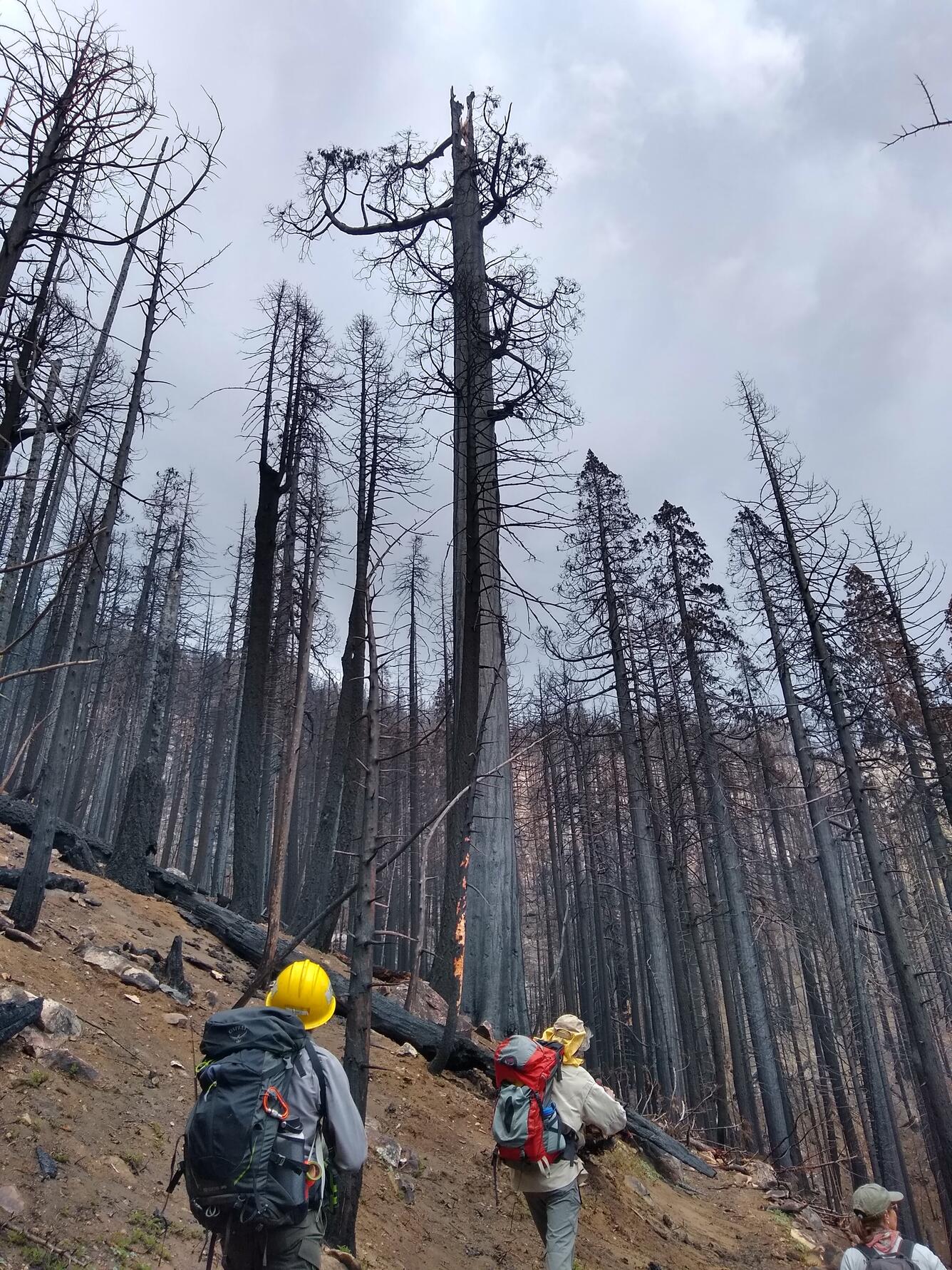
Managing Forests Following Wildfire
USGS science is used by National Park Service managers to make management decisions in Sequoia and Kings Canyon National Parks, where recent wildfires have killed large giant sequoias. The iconic species draws over 1.5 million tourists and sightseers to these two national parks each year bringing in important recreation and tourism dollars to the region amounting to \$196 million dollars for both parks together in 2022.
USGS researchers from Western Ecological Research Center and Geology, Energy, Minerals, and Geophysics Science Center are helping NPS land managers determine which areas are most likely to support successful sequoia seedling regeneration and to identify the most effective sequoia replanting strategies following wildfire.
This information is critical for informing park responses to wildfires, so that giant sequoia groves can persist into the future and impress generations to come.
Scientists from the USGS Ecosystems Land Change Science Program work hand-in-hand with park managers to support abundant and enduring outdoor recreation and tourism opportunities in the Nation’s national parks.
USGS science plays a key role in supporting the economic and other benefits of outdoor recreation and tourism on public lands, which depend on productive lands and waters abundant with fish and wildlife.
USGS scientists work with park managers to make high quality natural resource management decisions, ensuring these destinations continue to support outdoor recreation and tourism for generations to come.
Learn more about how the Land Change Science Program in the USGS Ecosystems Mission Area supports outdoor recreation and tourism in our national parks.
Supporting Recreation Operations in Glacier
In Glacier National Park, park managers rely on USGS expertise at Northern Rocky Mountain Science Center to provide on-site avalanche forecasting and place-based research for the Going-to-the-Sun Road – a major thoroughfare and tourist destination in the park.
Since the USGS Glacier National Park Avalanche Program began forecasting efforts in 2003, there have been no avalanche related injuries or fatalities, despite there being 1168 avalanche days with 607 avalanches that impacted the road over the 22-year period.
Further, in 2021, due to increased park visitation by tourists and access to higher stretches of road, USGS began providing weekend avalanche forecasts to the Visitor Protection Division at Glacier National Park, which uses those forecasts as the definitive measure of whether to close specific areas for public safety, saving lives and property.
Protecting Fragile Cultural and Paleontologic Resources in the Southwest
USGS science is used by National Park Service managers to make decisions regarding the protection and interpretation of fragile, non-renewable cultural and paleotonologic resources – such as ancient human footprints, megafaunal tracks, and vertebrate fossils. USGS scientists at the Geoscience and Environmental Change Science Center have been at the forefront of investigations leading to the discovery of these resources in the parks.
These resources draw recreationists to parks in the southwestern U.S., including Tule Springs Fossil Beds National Monument, White Sands National Park, Death Valley National Park, Grand Canyon National Park, Joshua Tree National Park, and Channel Islands National Park.
Protecting Park Infrastructure along the Gulf and Atlantic Coasts
Along the Gulf of America and Atlantic coasts, national parks and preserves are vulnerable to sea-level rise, which threatens to inundate irreplaceable historic buildings, archeological sites, and other infrastructure located in low-lying areas.
USGS scientists at the Wetland and Aquatic Research Center partnered with the National Park Service to develop maps projecting future sea-level rise for federally managed units in the region. They also published a series of USGS Fact Sheets about projected sea-level rise and high tide flooding at six parks in the region, in collaboration with their partners.
National Park Service and other federal land managers are using this information to inform park infrastructure and resource plans.
Managing Drylands for Recreation on the Colorado Plateau
Many drylands in the west are managed for recreation and domestic livestock grazing, which generates billions of dollars of revenue for the federal government and contributes hundreds of millions of dollars to local communities.
USGS scientists at Southwest Biological Science Center work with public land managers and ranchers to develop strategies to help avoid the most deleterious impacts of drought and invasives through management and restoration.
For example, USGS is working with National Park Service to test new restoration techniques to address drought-driven land degradation in Canyonlands and Arches National Parks, which together welcomed over 1.5 million visitors in 2024. The USGS is also working with ranchers and partners to test livestock breeds and management techniques that may help mitigate impacts of drought on ranchers and rangelands.
Providing Scientific Information on Glacier National Park’s Namesake
Visitors to Glacier National Park want to know about the status of its namesake glaciers. USGS glaciologists at the Northern Rocky Mountain Science Center work with the park to deliver this information. Using a combination of remote sensing and field campaigns, USGS conducts research that quantifies and elucidates glacier change.
USGS data derived from historic maps and geologic interpretation of modern satellite imagery document glacier changes from the mid-19th century to the modern era. Starting in 2005, the USGS Benchmark Glacier Project has collected direct measurements of glacier mass balance on Sperry Glacier.
Preserving an Iconic Landscape in Rocky Mountain
In Rocky Mountain National Park, resource managers rely on USGS research and monitoring data on alpine and subalpine lakes to understand how these iconic ecosystems are impacted by disturbances, like atmospheric nitrogen deposition, and how to preserve them for future generations.
The research partnership between USGS scientists at Fort Collins Science Center and the park began in the 1980s and has been ongoing for 40+ years. As a result of USGS research, NPS, EPA, and the State of Colorado created a voluntary Nitrogen Deposition Reduction Plan with the goal of reducing nitrogen pollution to protect Rocky Mountain National Park resources through voluntary collaboration and emissions reduction with stakeholders.
Understanding Recreational Resources that Enrich Visitor Experience at Dinosaur National Monument
Park managers at Dinosaur National Monument are tasked with planning for future environmental changes that impact the cultural, natural, and recreational resources at the park. One aspect of future readiness is documenting unique resources there, such as Ponderosa pine growing on the meander benches of the Green and Yampa Rivers that traverse the park. These rivers are iconic destinations for commercial and private boating.
USGS science is providing the expertise to document the natural history of streamside Ponderosa pine – including population, age, and establishment patterns of these trees. USGS scientists from the Geosciences and Environmental Change Science Center are also using the rings of the meander-bench Ponderosa pine to develop climate and streamflow reconstructions of the Yampa River, providing historical benchmarks of extreme streamflow to help managers understand what could be possible under future drought conditions.
Park management teams are using this USGS science to plan ecological recovery and restoration efforts at the park, ensuring these recreational resources persist in the years to come.
Managing Forests Following Wildfire
USGS science is used by National Park Service managers to make management decisions in Sequoia and Kings Canyon National Parks, where recent wildfires have killed large giant sequoias. The iconic species draws over 1.5 million tourists and sightseers to these two national parks each year bringing in important recreation and tourism dollars to the region amounting to \$196 million dollars for both parks together in 2022.
USGS researchers from Western Ecological Research Center and Geology, Energy, Minerals, and Geophysics Science Center are helping NPS land managers determine which areas are most likely to support successful sequoia seedling regeneration and to identify the most effective sequoia replanting strategies following wildfire.
This information is critical for informing park responses to wildfires, so that giant sequoia groves can persist into the future and impress generations to come.