
An eel ladder constructed along the Eden Mill Damn to help American eels make their way up and over the water.
Images
See more about our science.
Filter Total Items: 117
Eden Mill Eel Ladder
An eel ladder constructed along the Eden Mill Damn to help American eels make their way up and over the water.
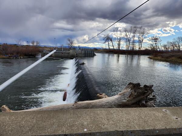
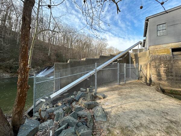
Dam in the lower Yakima River
This is a photo of a dam in the lower Yakima River. Efforts to ameliorate the negative effects of diversion dams on aquatic species of concern are important in rivers where water withdrawal supports agricultural economies, and they are likely to become increasingly important with impending climate change.
This is a photo of a dam in the lower Yakima River. Efforts to ameliorate the negative effects of diversion dams on aquatic species of concern are important in rivers where water withdrawal supports agricultural economies, and they are likely to become increasingly important with impending climate change.
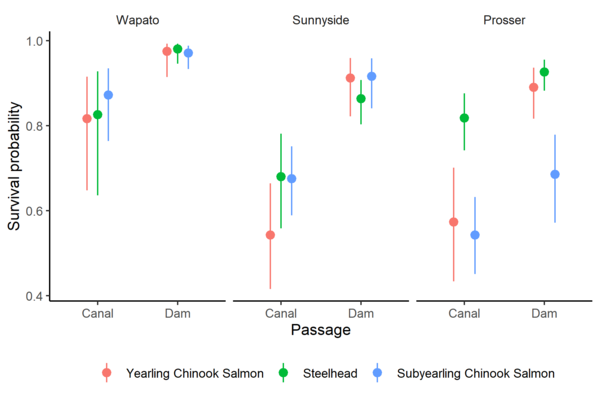
Survival Probabilities of Fish Through Canals Versus Dams
Survival Probabilities of Fish Through Canals Versus DamsSurvival probability estimates and 95% confidence intervals for yearling Chinook Salmon, juvenile steelhead, and subyearling Chinook Salmon at three diversion dams on the Yakima River, Washington.
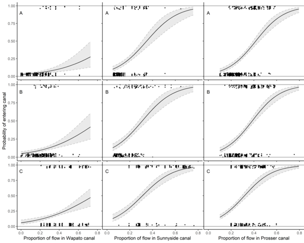
Nine Panel Plot of Fish Passage Entrainment vs Canal Flow
Nine Panel Plot of Fish Passage Entrainment vs Canal FlowEstimated relationship between entrainment probability and proportion of river flow entering canals at Wapato Dam, Sunnyside Dam, and Prosser Dam on the Yakima River, Washington. The relationships are shown at the mean total river flow for (A) yearling Chinook Salmon, (B) juvenile steelhead, and (C) subyearling Chinook Salmon.
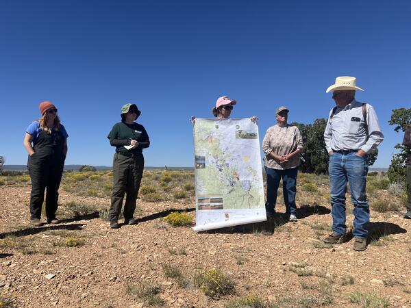
Researchers and ranchers discuss land management in Northern Arizona
Researchers and ranchers discuss land management in Northern ArizonaResearchers from the U.S. Geological Survey and University of Arizona collaborate with Diablo Trust ranchers on range improvement and restoration efforts on Northern Arizona rangelands. Photo by Jessica Archibald (Diablo Trust).
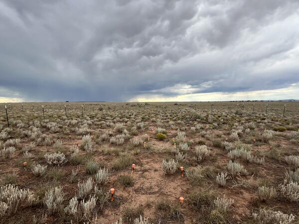
Monsoon season at a Northern Arizona RestoreNet site
Monsoon season at a Northern Arizona RestoreNet siteA RestoreNet site in Northern Arizona with late summer monsoon rain clouds in the background. Photo by Laura Shriver.
Monsoon season at a Northern Arizona RestoreNet site
Monsoon season at a Northern Arizona RestoreNet siteA RestoreNet site in Northern Arizona with late summer monsoon rain clouds in the background. Photo by Laura Shriver.
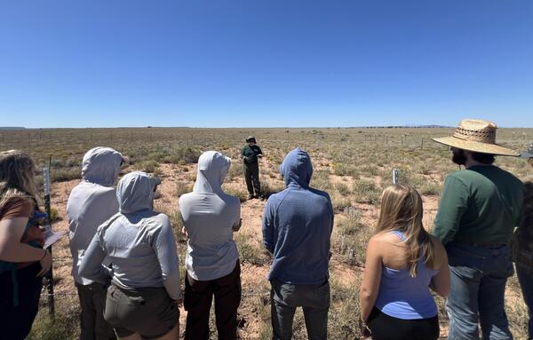
A USGS Ecologist gives a tour of a Northern Arizona RestoreNet site
A USGS Ecologist gives a tour of a Northern Arizona RestoreNet siteLaura Shriver, RAMPS coordinator, gives a tour of a Northern Arizona RestoreNet site to Northern Arizona University students. Photo by Jessica Archibald (Diablo Trust).

Discover Ecosystems
America’s diverse ecosystems are an asset to current and future generations by supporting economically and recreationally important fish, wildlife, and lands. Healthy ecosystems support people and nature, fostering prosperity and enjoyment for all.
By
Ecosystems Mission Area, Biological Threats and Invasive Species Research Program, Climate Adaptation Science Centers, Cooperative Research Units, Ecosystems Land Change Science Program, Environmental Health Program, Land Management Research Program, Species Management Research Program, Communications and Publishing

Discover Ecosystems
America’s diverse ecosystems are an asset to current and future generations by supporting economically and recreationally important fish, wildlife, and lands. Healthy ecosystems support people and nature, fostering prosperity and enjoyment for all.
America’s diverse ecosystems are an asset to current and future generations by supporting economically and recreationally important fish, wildlife, and lands. Healthy ecosystems support people and nature, fostering prosperity and enjoyment for all.

RestoreNet Map
RestoreNet is a networked ecological restoration experiment spanning drylands of the American Southwest. It is engaging diverse partners to develop methods for successful revegetation projects that mitigate the effects of drought, invasion by non-native species, and land use practices.
RestoreNet is a networked ecological restoration experiment spanning drylands of the American Southwest. It is engaging diverse partners to develop methods for successful revegetation projects that mitigate the effects of drought, invasion by non-native species, and land use practices.

Dozer Line through Repaired Habitat Supervised by SPARCS Fireline Resource Advisors during the Palisades Fire
Dozer Line through Repaired Habitat Supervised by SPARCS Fireline Resource Advisors during the Palisades FireBulldozer lines create breaks in vegetation and are commonly used when fighting wildfires. This dozer line was created during the Palisades Fire in Los Angeles County, California in January 2025.

A Sonoran Desert RestoreNet site
A RestoreNet Field Trial Network restoration experiment site in the Sonoran Desert, Arizona, in spring 2024. Photo by Laura Shriver (USGS).
A RestoreNet Field Trial Network restoration experiment site in the Sonoran Desert, Arizona, in spring 2024. Photo by Laura Shriver (USGS).
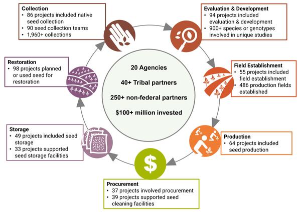
Accomplishments in Native Seed Development in 2022 and 2023
Accomplishments in Native Seed Development in 2022 and 2023Accomplishments in Native Seed Development.
Accomplishments in Native Seed Development in 2022 and 2023
Accomplishments in Native Seed Development in 2022 and 2023Accomplishments in Native Seed Development.

Canyonlands Research Center
Scenic view of the red rock mesas surrounding Canyonlands Research Center (The Nature Conservancy) in southern Utah.
Scenic view of the red rock mesas surrounding Canyonlands Research Center (The Nature Conservancy) in southern Utah.
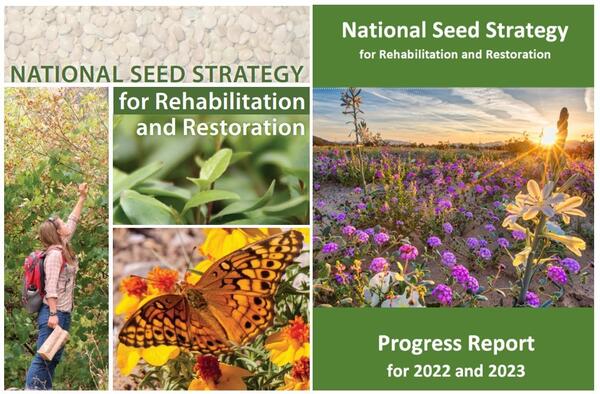
Covers of the National Seed Strategy and National Seed Strategy Progress Report for 2022 and 2023
Covers of the National Seed Strategy and National Seed Strategy Progress Report for 2022 and 2023Covers of the Plant Conservation Alliance National Seed Strategy Progress Report for 2022 and 2023 (left) and the National Seed Strategy for Rehabilitation and Restoration (right).

RestoreNet livestock treatments
Cattle inside a grazing enclosure at Canyonlands Research Center (The Nature Conservancy) in southern Utah.
Cattle inside a grazing enclosure at Canyonlands Research Center (The Nature Conservancy) in southern Utah.
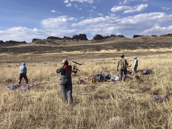
Soil sampling in Colorado
A USGS field crew working on soil sampling, plant community monitoring, and soil water infiltration in the Colorado 'front range.'
A USGS field crew working on soil sampling, plant community monitoring, and soil water infiltration in the Colorado 'front range.'

Pit for sampling soil carbon
USGS scientists dig small ‘micro pits' to collect soil for testing. The team is careful to minimize the impact to the environment. Soil is stored on a tarp while sampling so it can be returned to the pit afterwards.
USGS scientists dig small ‘micro pits' to collect soil for testing. The team is careful to minimize the impact to the environment. Soil is stored on a tarp while sampling so it can be returned to the pit afterwards.

Measuring soil water infiltration
A USGS scientist prepares a mini-disc infiltrometer to assess soil water infiltration. The degree to which water can infiltrate soil is closely tied to soil carbon content.
A USGS scientist prepares a mini-disc infiltrometer to assess soil water infiltration. The degree to which water can infiltrate soil is closely tied to soil carbon content.

Plant community monitoring in Colorado
A USGS scientist uses the grid-point intercept method to characterize plant communities in Larimer County, Colorado. The grid-point intercept method uses points along a grid to sample plant species or ground cover within a larger plot.
A USGS scientist uses the grid-point intercept method to characterize plant communities in Larimer County, Colorado. The grid-point intercept method uses points along a grid to sample plant species or ground cover within a larger plot.

Identifying grass species in Colorado
USGS scientists identifying plant community composition in Larimer County, Colorado. Information on plant community composition is critical for understanding differences in soil carbon-responses to exotic annual grass invasion between sites.
USGS scientists identifying plant community composition in Larimer County, Colorado. Information on plant community composition is critical for understanding differences in soil carbon-responses to exotic annual grass invasion between sites.