
This landscape in Rabbit Valley in Colorado was burned and then invaded by the exotic annual grass cheatgrass. A formerly diverse plant community was replaced by a sea of highly flammable grass.
Images
See more about our science.
Filter Total Items: 117

Burned landscape invaded by cheatgrass
This landscape in Rabbit Valley in Colorado was burned and then invaded by the exotic annual grass cheatgrass. A formerly diverse plant community was replaced by a sea of highly flammable grass.

Vegetation and soil data collection at Castle Rocks, Idaho
Vegetation and soil data collection at Castle Rocks, IdahoA Project ROAM (Rapid and Other Methods for Assessment and Monitoring) crew collecting vegetation data at a complex plot with over 40 unique species.
Vegetation and soil data collection at Castle Rocks, Idaho
Vegetation and soil data collection at Castle Rocks, IdahoA Project ROAM (Rapid and Other Methods for Assessment and Monitoring) crew collecting vegetation data at a complex plot with over 40 unique species.
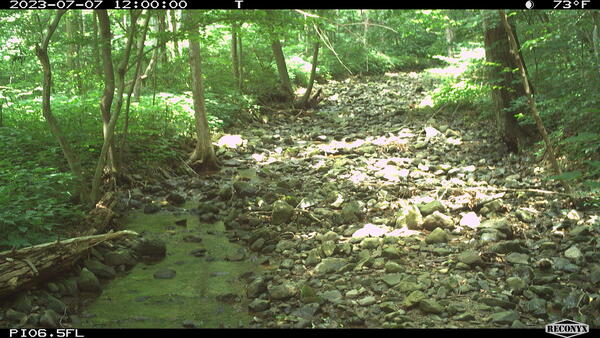
PI_06.5 Isolated pools
A still image taken from a USGS Flow Photo Explorer camera (Pl_06.5) shows isolated pools in a small stream in Shenandoah National Park.
A still image taken from a USGS Flow Photo Explorer camera (Pl_06.5) shows isolated pools in a small stream in Shenandoah National Park.

RAMPS hosts park restoration ecologist from South Africa
RAMPS hosts park restoration ecologist from South AfricaRAMPS and NPS host South African National Park scientist, Dr. Mmoto Masubelele, for field visits to exchange information on restoration and climate adaptation strategies. From left to right: Seth Munson, Dr. Mmoto Masubelele, park biologist Mark Szydlo. Photo by Seth Munson (USGS).
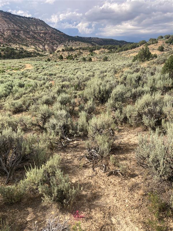
Undisturbed sagebrush landscape in Wyoming
This site south of Rock Springs in Wyoming represents an intact sagebrush ecosystem. It has not been burned or invaded by exotic annual grasses. Undisturbed sagebrush steppe has bare ground between shrubs which helps to limit the spread of wildfire. When cheatgrass invades fires can grow larger.
This site south of Rock Springs in Wyoming represents an intact sagebrush ecosystem. It has not been burned or invaded by exotic annual grasses. Undisturbed sagebrush steppe has bare ground between shrubs which helps to limit the spread of wildfire. When cheatgrass invades fires can grow larger.

Waiting on the wing
A large quadcopter drone rests on the tailgate of a truck waiting to fly with hyperspectral imagery to estimate vegetation cover.
A large quadcopter drone rests on the tailgate of a truck waiting to fly with hyperspectral imagery to estimate vegetation cover.

Drone ready to fly
A quadcopter drone rests on the orange landing pad, ready to fly over Rapid and Other Methods for Assessment and Monitoring (ROAM) plots to collect data that will be used to generate cover and density estimates.
A quadcopter drone rests on the orange landing pad, ready to fly over Rapid and Other Methods for Assessment and Monitoring (ROAM) plots to collect data that will be used to generate cover and density estimates.
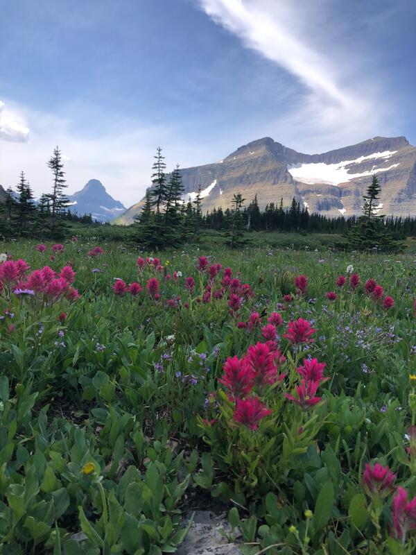
Glacier National Park
A picture of Glacier National Park with native plants, including Indian paintbrushes in the foreground, confiders in the midground, and snowy mountains in the background. Photo by Linsday Dose, USGS contractor.
A picture of Glacier National Park with native plants, including Indian paintbrushes in the foreground, confiders in the midground, and snowy mountains in the background. Photo by Linsday Dose, USGS contractor.

A close up of Sonoran Desert native wildflowers/forbs, including California poppy, lupines, and purple owl's clover
A close up of Sonoran Desert native wildflowers/forbs, including California poppy, lupines, and purple owl's cloverClose up of Sonoran Desert flowers, including California poppy, lupines, and purple owl's clover. Photo by Laura Shriver.

Sphaeralcea ambigua thriving at a Sonoran Desert RestoreNet site
Sphaeralcea ambigua thriving at a Sonoran Desert RestoreNet siteSphaeralcea ambigua, a native plant seeded during RestoreNet experiments, thriving at the Lake Pleasant RestoreNet site in the Sonoran Desert. Photo by Laura Shriver.
Sphaeralcea ambigua thriving at a Sonoran Desert RestoreNet site
Sphaeralcea ambigua thriving at a Sonoran Desert RestoreNet siteSphaeralcea ambigua, a native plant seeded during RestoreNet experiments, thriving at the Lake Pleasant RestoreNet site in the Sonoran Desert. Photo by Laura Shriver.

Purple owl's clover blooming at a Sonoran Desert RestoreNet site
Purple owl's clover blooming at a Sonoran Desert RestoreNet siteThe RestoreNet plot at McDowell Sonoran Preserve was surrounded by blooming native wildflowers, including purple owl's clover (Castillejia exserta). Photo by Laura Shriver.

RestoreNet ConMod with flowers in the Sonoran Desert
RestoreNet ConMod with flowers in the Sonoran DesertDiverse plants growing in a connectivity modified (ConMod) treatment in the Sonoran Desert. Photo by Molly McCormick.
RestoreNet ConMod with flowers in the Sonoran Desert
RestoreNet ConMod with flowers in the Sonoran DesertDiverse plants growing in a connectivity modified (ConMod) treatment in the Sonoran Desert. Photo by Molly McCormick.
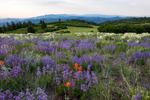
High Mesa Grassland Wilderness Study Area in Colorado
High Mesa Grassland Wilderness Study Area in ColoradoHigh Mesa Grassland Wilderness Study Area in Colorado with purple and orange wildflowers, Credit: Bob Wick, BLM.
High Mesa Grassland Wilderness Study Area in Colorado
High Mesa Grassland Wilderness Study Area in ColoradoHigh Mesa Grassland Wilderness Study Area in Colorado with purple and orange wildflowers, Credit: Bob Wick, BLM.

RestoreNet 2.0 restoration experiment sites with pits with seedballs on Northern Arizona rangelands
RestoreNet 2.0 restoration experiment sites with pits with seedballs on Northern Arizona rangelandsIn 2022, we piloted RestoreNet V2.0 testing soil inoculation from undegraded reference sites, seed balls (white balls in photo), and pitting treatments (small indentions). Soil inoculation with healthy soils is expected to increase beneficial microbes at the degraded restoration site. Soil microbes can help reduce water stress in plants. Photo by Hannah Farrell.
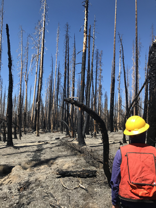
Dixie Fire, Lassen Volcanic National Park, California (2021)
Dixie Fire, Lassen Volcanic National Park, California (2021)USGS crew measuring forest conditions following the Dixie Fire in 2021. Lassen Volcanic National Park. California.
Dixie Fire, Lassen Volcanic National Park, California (2021)
Dixie Fire, Lassen Volcanic National Park, California (2021)USGS crew measuring forest conditions following the Dixie Fire in 2021. Lassen Volcanic National Park. California.

Historic Cans
Historic cans from a refuse pile that were scorched by the combustion of nearby fuels during the Caldor Fire, California. Copyright: photo taken by Grant Snitker, New Mexico Consortium.
Historic cans from a refuse pile that were scorched by the combustion of nearby fuels during the Caldor Fire, California. Copyright: photo taken by Grant Snitker, New Mexico Consortium.

Setting up Fuel Transects
Setting up fuel transects within an archaeological site at Sequoia National Park to understand potential future fire behavior and how it could affect artifacts within the site. Pictured: Grant Snitker (foreground) and Alex Fetteroff (background), New Mexico Consortium. Copyright: Photo by Grant Snitker, New Mexico Consortium.
Setting up fuel transects within an archaeological site at Sequoia National Park to understand potential future fire behavior and how it could affect artifacts within the site. Pictured: Grant Snitker (foreground) and Alex Fetteroff (background), New Mexico Consortium. Copyright: Photo by Grant Snitker, New Mexico Consortium.

A Precontact Rockshelter and Associated Artifacts
A precontact rockshelter and associated artifacts impacted by the combustion of heavy fuels during the KNP Complex Fire, California. Copyright: photo by Grant Snitker, New Mexico Consortium.
A precontact rockshelter and associated artifacts impacted by the combustion of heavy fuels during the KNP Complex Fire, California. Copyright: photo by Grant Snitker, New Mexico Consortium.

Using Terrestrial LiDAR
Using terrestrial LiDAR to characterize fuels within an archaeological site at Sequoia National Park site to understand potential future fire behavior and its effects on artifacts. Copyright: Photo by Grant Snitker, New Mexico Consortium.
Using terrestrial LiDAR to characterize fuels within an archaeological site at Sequoia National Park site to understand potential future fire behavior and its effects on artifacts. Copyright: Photo by Grant Snitker, New Mexico Consortium.

Graphic showing potential benefits of RestoreNet 2.0 treatments, including seeding, live topsoil inoculation, livestock grazing, seed balls, and soil pits
Graphic showing potential benefits of RestoreNet 2.0 treatments, including seeding, live topsoil inoculation, livestock grazing, seed balls, and soil pitsGraphic showing potential benefits of RestoreNet 2.0 treatments, including seeding, live topsoil inoculation, livestock grazing, seed balls, and soil pits
Graphic showing potential benefits of RestoreNet 2.0 treatments, including seeding, live topsoil inoculation, livestock grazing, seed balls, and soil pitsGraphic showing potential benefits of RestoreNet 2.0 treatments, including seeding, live topsoil inoculation, livestock grazing, seed balls, and soil pits

RestoreNet restoration teatments in the Sonoran Desert
RestoreNet restoration teatments in the Sonoran DesertRestoreNet treatments include soil pits and connectivity modifiers (ConMods), seen here at a RestoreNet site in the Sonoran Desert.
RestoreNet restoration teatments in the Sonoran Desert
RestoreNet restoration teatments in the Sonoran DesertRestoreNet treatments include soil pits and connectivity modifiers (ConMods), seen here at a RestoreNet site in the Sonoran Desert.