Actively eroding coastal permafrost bluff on Barter Island
Actively eroding coastal permafrost bluff on Barter IslandPhotograph of the actively eroding coastal permafrost bluff on Barter Island, located on the northern coast of Alaska.

Official websites use .gov
A .gov website belongs to an official government organization in the United States.
Secure .gov websites use HTTPS
A lock () or https:// means you’ve safely connected to the .gov website. Share sensitive information only on official, secure websites.
Browse images from a wide range of science topics covered by USGS.

Photograph of the actively eroding coastal permafrost bluff on Barter Island, located on the northern coast of Alaska.
Photograph of the actively eroding coastal permafrost bluff on Barter Island, located on the northern coast of Alaska.

View looking east of the actively eroding coastal permafrost bluff on Barter Island, which is located on the northern coast of Alaska.
View looking east of the actively eroding coastal permafrost bluff on Barter Island, which is located on the northern coast of Alaska.

Scientists Cordell Johnson, left, and Li Erikson stand atop the coastal bluff of Barter Island in northern Alaska, a coastal area that is experiencing very high rates of erosion.
Scientists Cordell Johnson, left, and Li Erikson stand atop the coastal bluff of Barter Island in northern Alaska, a coastal area that is experiencing very high rates of erosion.

Christina Ahlstrom holding a gull tagging with a satellite transmitter.
Christina Ahlstrom holding a gull tagging with a satellite transmitter.

An oblique perspective of Alaska's Denali Mountain visualized by 3D Elevation Program lidar data.
An oblique perspective of Alaska's Denali Mountain visualized by 3D Elevation Program lidar data.

Black-legged Kittiwakes forage on Pacific sand lance and capelin near their colony on Gull Island, Cook Inlet on June 28, 2018.
Black-legged Kittiwakes forage on Pacific sand lance and capelin near their colony on Gull Island, Cook Inlet on June 28, 2018.

Female McKay's Bunting on St. Matthew Island.
Female McKay's Bunting on St. Matthew Island.

Male McKay's Bunting on St. Matthew Island
Male McKay's Bunting on St. Matthew Island
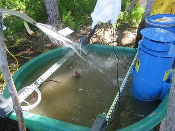
An experimental tank used in a thermal challenge experiment for adult salmonids. The upper lobe of an adult Chinook salmon (Oncorhynchus tshawytscha) caudal fin is visible in the center of the water surface.
An experimental tank used in a thermal challenge experiment for adult salmonids. The upper lobe of an adult Chinook salmon (Oncorhynchus tshawytscha) caudal fin is visible in the center of the water surface.

Ocean bottom seismometers being loaded onto the R/V Sikuliaq to be deployed on the sea floor in the Gulf of Alaska.
Ocean bottom seismometers being loaded onto the R/V Sikuliaq to be deployed on the sea floor in the Gulf of Alaska.

Stratigraphic contact marking uplift of Montague Island, caused by slip on the Patton Bay fault system during the 1964 M9.2 Great ALaska Earthquake.
Stratigraphic contact marking uplift of Montague Island, caused by slip on the Patton Bay fault system during the 1964 M9.2 Great ALaska Earthquake.

Hot springs can occur in many parts of the world. The water is hot not due to climate, but rather due to geothermal activity underground, such as volcanic activity or active hydrothermal heating from hot material in the ground. Hot springs result from water heated by underground geothermal activity finding its way to the land surface.
Hot springs can occur in many parts of the world. The water is hot not due to climate, but rather due to geothermal activity underground, such as volcanic activity or active hydrothermal heating from hot material in the ground. Hot springs result from water heated by underground geothermal activity finding its way to the land surface.

USGS and Geological Survey of Canada scientists sample sediment cores collected from the sea floor along the Queen Charlotte Fault. This was taken while they were working with (or in) the Geological Survey of Canada.
USGS and Geological Survey of Canada scientists sample sediment cores collected from the sea floor along the Queen Charlotte Fault. This was taken while they were working with (or in) the Geological Survey of Canada.
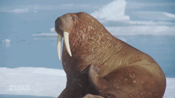
An animated GIF showing a Pacific Walrus scratching/rubbing themselves on their side with their "eye" rolling. The animation repeats in a reverse-motion.
An animated GIF showing a Pacific Walrus scratching/rubbing themselves on their side with their "eye" rolling. The animation repeats in a reverse-motion.

Landscape view of an un-named glacier off the Sargent Icefield, directly across from Wolverine Glacier, above the Nellie Juan River, in Alaska. Taken during a visit to a wolverine glacier field site as part of a study to examine how alpine areas are changing as temperatures rise in Alaska.
Landscape view of an un-named glacier off the Sargent Icefield, directly across from Wolverine Glacier, above the Nellie Juan River, in Alaska. Taken during a visit to a wolverine glacier field site as part of a study to examine how alpine areas are changing as temperatures rise in Alaska.

Fish Creek wanders through the National Petroleum Reserve-Alaska, a 22.8 million acre region managed by the Bureau of Land Management on Alaska's North Slope. USGS has periodically assessed oil and gas resource potential there. These assessments can be found here.
Fish Creek wanders through the National Petroleum Reserve-Alaska, a 22.8 million acre region managed by the Bureau of Land Management on Alaska's North Slope. USGS has periodically assessed oil and gas resource potential there. These assessments can be found here.

Tracklines along which R/V Ocean Starr (2017, red lines) and R/V Norseman (2016, black lines) conducted seismic-reflection surveys, overlaid on high-resolution bathymetry (color background). Yellow stars represent earthquakes of magnitude (M) 7 and greater since 1900.
Tracklines along which R/V Ocean Starr (2017, red lines) and R/V Norseman (2016, black lines) conducted seismic-reflection surveys, overlaid on high-resolution bathymetry (color background). Yellow stars represent earthquakes of magnitude (M) 7 and greater since 1900.

Permafrost forms a grid-like pattern in the National Petroleum Reserve-Alaska, a 22.8 million acre region managed by the Bureau of Land Management on Alaska's North Slope. USGS has periodically assessed oil and gas resource potential there. These assessments can be found here.
Permafrost forms a grid-like pattern in the National Petroleum Reserve-Alaska, a 22.8 million acre region managed by the Bureau of Land Management on Alaska's North Slope. USGS has periodically assessed oil and gas resource potential there. These assessments can be found here.

USGS hydrologist monitoring water quality and collecting samples at USGS Station15015595 on the Unuk River, Alaska. In 2019, the USGS began studying the baseline water-quality of selected transboundary rivers in Alaska.
USGS hydrologist monitoring water quality and collecting samples at USGS Station15015595 on the Unuk River, Alaska. In 2019, the USGS began studying the baseline water-quality of selected transboundary rivers in Alaska.

Emperor geese gathered near the shoreline on Kodiak Island.
Emperor geese gathered near the shoreline on Kodiak Island.
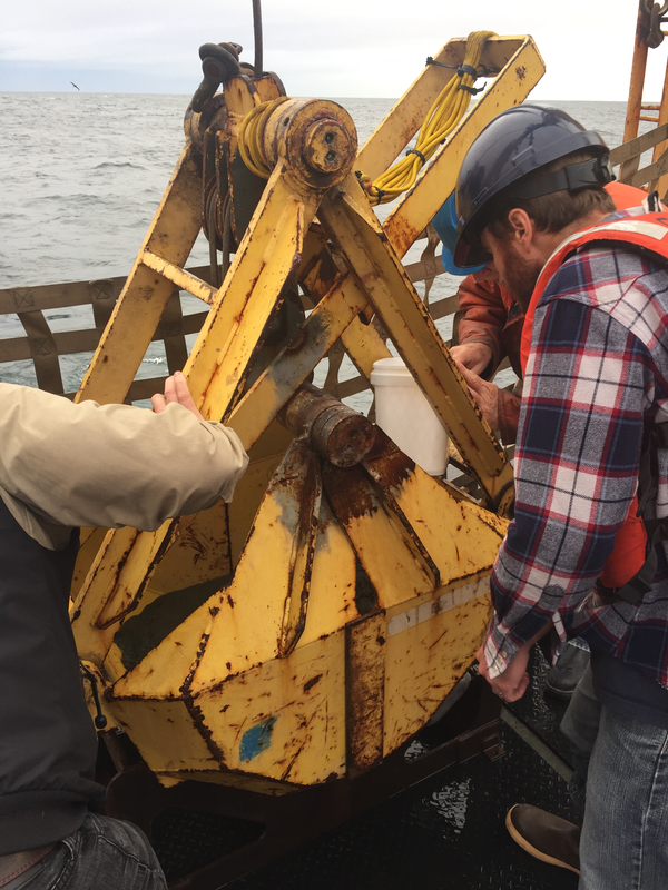
USGS research geophysicist Danny Brothers (right) and colleagues examine the surface of a sediment grab sample just pulled onto the deck of the Canadian Coast Guard Ship John P. Tully. The sample was collected from the top of a mud volcano north of the border between southeast Alaska and British Columbia.
USGS research geophysicist Danny Brothers (right) and colleagues examine the surface of a sediment grab sample just pulled onto the deck of the Canadian Coast Guard Ship John P. Tully. The sample was collected from the top of a mud volcano north of the border between southeast Alaska and British Columbia.