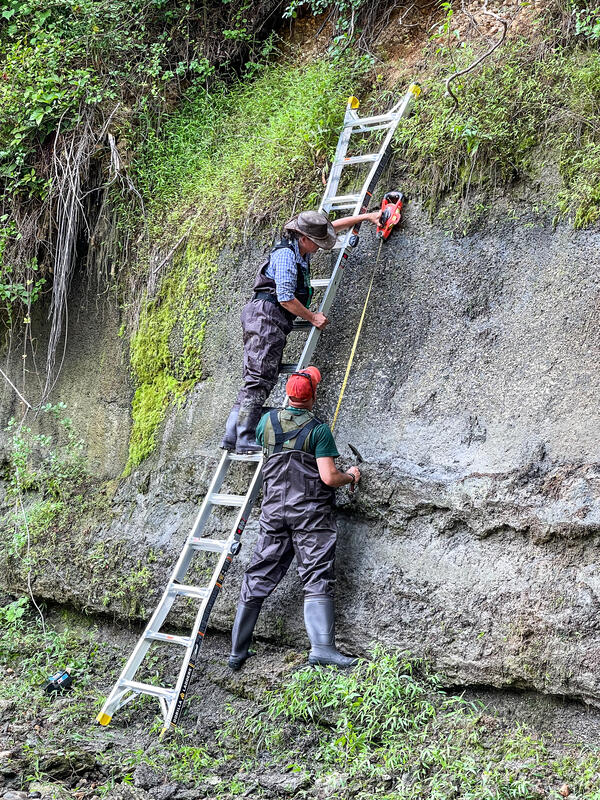
The Region 1, May 2021 "Honorable Mention #1" Winner (by Chelsea Delsack)
Images
Images below come from a wide variety of USGS science activities in the Northeast Region. Science Center staff showcase what we do, who we are, and where we work conducting science that inform decision makers and addresses societal needs.
The Region 1, May 2021 "Honorable Mention #1" Winner (by Chelsea Delsack)
A USGS scientist wearing black gloves is collecting a sample of tap water from the kitchen sink using small plastic vials to test for PFAS.
Multi-parameter probes, temperature and dissolved oxygen sensors
Multi-parameter probes, temperature and dissolved oxygen sensors(A) Examples of the multi-parameter water-quality probes used for continuous fixed-station monitoring, moving boat surveys, and vertical water-quality profiles. (B) Example of smaller temperature and dissolved oxygen sensors with and without a wiper unit.
Examples of monitoring buoys deployed in (A) 2018 and (B) 2019 and (C) example of a bottom cage containing a sensor.
USGS Station ID 01075000 Pemigewasset River high-water mark monument
USGS Station ID 01075000 Pemigewasset River high-water mark monumentUSGS station ID 01075000 Pemigewasset River at Woodstock, New Hampshire. The high-water mark monument was installed in May 2021, and shows the peak for the period of record at this gage was from Tropical Storm Irene. It still remains the highest peak to this day.
The Region 1, April 2021 "Honorable Mention #1" Winner (by Chelsea Delsack)
Hydrologic Technician Andy Cloutier visited USGS gaging station 01069500 on the Mousam River at West Kennebunk, Maine in mid-April of 2021.
The Region 1, May 2021 "People" Winner (by Heather Walsh)
Continuous stage only gaging station located at Mystic River at Rt. 1 bridge, Connecticut (USGS Site ID 412117071580800)
Tidal monitoring gage on a drawbridge over the Mystic River in Mystic, Connecticut.
The Region 1, April 2021 "Honorable Mention #2" Winner (by Bonnie McDevitt)
The Region 1, April 2021 "USGS at Work" Winner (by Alex Olson)
Studying the mountain streams and rivers of New England means never being too far from a scenic and historic waterfall, like the Burlington Falls on Bunnell Brook pictured here. This natural resource attracted small industries to a mostly rural Burlington, CT in the early-19th century.
Gainer Memorial Dam, Scituate Reservoir, Rhode Island
Gainer Memorial Dam, Scituate Reservoir, Rhode IslandThe north side of the Gainer Memorial Dam, Scituate Reservoir, Rhode Island.
Gainer Memorial Dam, Scituate Reservoir, Rhode Island
Gainer Memorial Dam, Scituate Reservoir, Rhode IslandThe north side of the Gainer Memorial Dam, Scituate Reservoir, Rhode Island.
The south side of the Gainer Memorial Dam, Scituate Reservoir, Rhode Island. The reservoir began storing water on November 10, 1925.
A long exposure shot shows the flow and direction of water through the gage pool during a high-flow event in April 2021. Looking upstream you can see the staff plate and a felled tree which is not impacting flow.
Woods Hole Sediment Analysis Lab's Rigaku Miniflex 600
Woods Hole Sediment Analysis Lab's Rigaku Miniflex 600Woods Hole Coastal and Marine Science Center Sediment Analysis Laboratory's Rigaku Miniflex 600 (USGS laboratory equipment number WH-SED-Rigaku-Miniflex1).
Woods Hole Sediment Analysis Lab's Rigaku Miniflex 600
Woods Hole Sediment Analysis Lab's Rigaku Miniflex 600Woods Hole Coastal and Marine Science Center Sediment Analysis Laboratory's Rigaku Miniflex 600 (USGS laboratory equipment number WH-SED-Rigaku-Miniflex1).
Woods Hole Sediment Analysis Lab's Beckman Coulter Multisizer 3
Woods Hole Sediment Analysis Lab's Beckman Coulter Multisizer 3Woods Hole Coastal and Marine Science Center Sediment Analysis Laboratory's Beckman Coulter Multisizer 3 (USGS laboratory equipment number WH-SED-BeckmanCoulter-Multisizer1).
Photo Contest Winner | March 2021 | Where We Work
Aerial photo of Cold River in Maine
Photo Contest Winner | March 2021 | Where We Work
Aerial photo of Cold River in Maine