
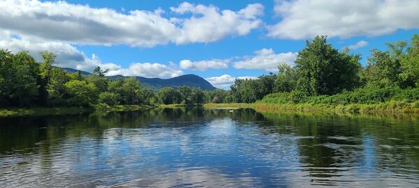
A downstream view of the Green River near Colrain, Massachusetts close to the USGS streamgage (01170100). The low-flow was about 7.7 cubic feet per second (cfs) for a 41.4-square-mile drainage area.
Images
Images below come from a wide variety of USGS science activities in the Northeast Region. Science Center staff showcase what we do, who we are, and where we work conducting science that inform decision makers and addresses societal needs.
Filter Total Items: 2050

Green River near Colrain, Massachusetts
A downstream view of the Green River near Colrain, Massachusetts close to the USGS streamgage (01170100). The low-flow was about 7.7 cubic feet per second (cfs) for a 41.4-square-mile drainage area.

Pearl Hill Brook in Ashby, Massachusetts
Pearl Hill Brook at Mill Creek Drive in Ashby, Massachusetts on October 1, 2021. The drop at the outflow of the culvert would impede aquatic organism passage.
Pearl Hill Brook at Mill Creek Drive in Ashby, Massachusetts on October 1, 2021. The drop at the outflow of the culvert would impede aquatic organism passage.

Unnamed tributary to Trapfall Brook in Ashby, Massachusetts
Unnamed tributary to Trapfall Brook in Ashby, MassachusettsUnnamed tributary to Trapfall Brook at Harris Road in Ashby, Massachusetts, on October 1, 2021. The shallowness of water in the culvert could impede aquatic organism passage.
Unnamed tributary to Trapfall Brook in Ashby, Massachusetts
Unnamed tributary to Trapfall Brook in Ashby, MassachusettsUnnamed tributary to Trapfall Brook at Harris Road in Ashby, Massachusetts, on October 1, 2021. The shallowness of water in the culvert could impede aquatic organism passage.
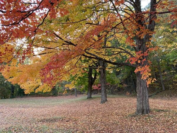
Autumn splendor at Wachusett Reservoir confluence
Vibrant autumn foliage of maple trees near the confluence of the Stillwater and Quinapoxet Rivers at the Wachusett Reservoir in West Boylston, Massachusetts.
Vibrant autumn foliage of maple trees near the confluence of the Stillwater and Quinapoxet Rivers at the Wachusett Reservoir in West Boylston, Massachusetts.

DOI partners for native fish restoration in Catoctin Mountain Park
DOI partners for native fish restoration in Catoctin Mountain ParkDOI partners celebrating a day of restoring native Blue Ridge sculpin to a stream in Catoctin Mountain Park, Maryland. The team includes researchers from the USGS Eastern Ecological Science Center, resource managers from the National Park Service, and wildlife videographers from the US Fish and Wildlife Service.

A railroad crossing over the Penobscot River in Grindstone, Maine
A railroad crossing over the Penobscot River in Grindstone, MaineA railroad crossing over the East Branch Penobscot River located at a streamgage 01029500 in Grindstone, Maine
A railroad crossing over the Penobscot River in Grindstone, Maine
A railroad crossing over the Penobscot River in Grindstone, MaineA railroad crossing over the East Branch Penobscot River located at a streamgage 01029500 in Grindstone, Maine

Earth MRI Airborne Geophysical Survey Helicopter with Boom
Earth MRI Airborne Geophysical Survey Helicopter with BoomA helicopter with a boom that contains sensitive equipment for conducting airborne geophysical surveys.
Earth MRI Airborne Geophysical Survey Helicopter with Boom
Earth MRI Airborne Geophysical Survey Helicopter with BoomA helicopter with a boom that contains sensitive equipment for conducting airborne geophysical surveys.

Earth MRI Aircraft with Boom
Airborne geophysical surveys make use of a boom with sensitive equipment installed on small aircraft.
Airborne geophysical surveys make use of a boom with sensitive equipment installed on small aircraft.

Collecting water quality samples from the New River Gorge
Collecting water quality samples from the New River GorgeCollecting water quality samples from the New River Gorge in support of USGS-NPS partnership.
Fall 2022 Photo Contest Winner: Matt Kearns, USGS at Work category
Collecting water quality samples from the New River Gorge
Collecting water quality samples from the New River GorgeCollecting water quality samples from the New River Gorge in support of USGS-NPS partnership.
Fall 2022 Photo Contest Winner: Matt Kearns, USGS at Work category
Panoramic view of the East Branch Penobscot River from the Big Seboeis Area
Panoramic view of the East Branch Penobscot River from the Big Seboeis AreaPanoramic view of the East Branch Penobscot River from the Big Seboeis area within the Katahdin Woods and Water National Monument in Maine.
Panoramic view of the East Branch Penobscot River from the Big Seboeis Area
Panoramic view of the East Branch Penobscot River from the Big Seboeis AreaPanoramic view of the East Branch Penobscot River from the Big Seboeis area within the Katahdin Woods and Water National Monument in Maine.

Non-motorized boat course
Non-motorized watercraft training practical exercises (canoe rescues) in Buffumville Lake, Oxford, MA
Summer 2022 Photo Contest: Andrew Massey, Honorable Mention category
Non-motorized watercraft training practical exercises (canoe rescues) in Buffumville Lake, Oxford, MA
Summer 2022 Photo Contest: Andrew Massey, Honorable Mention category

Low Streamflow at U.S. Geological Survey Ipswich River streamgage (01102000) near Ipswich, MA
Low Streamflow at U.S. Geological Survey Ipswich River streamgage (01102000) near Ipswich, MAA low streamflow of 0.07 cubic feet/second (cfs) was measured at the U.S. Geological Survey Ipswich River streamgage (01102000) near Ipswich, MA on August 24, 2022. The concrete weir near the site is visible due to the low flows. The drainage area is 125 square miles.

Differential leveling techniques are performed to determine reference-mark elevations at historic streamgage
Differential leveling techniques are performed to determine reference-mark elevations at historic streamgageDifferential leveling techniques are performed by Alex Wong to determine reference-mark elevations at historic USGS streamgage, 01303000 Mill Neck Creek in Mill Neck, NY.
Summer 2022 Photo Contest Winner: Amy Simonson, Where We Work category

Low Streamflow in the Byram River in Pemberwick, Connecticut
Low Streamflow in the Byram River in Pemberwick, ConnecticutHydrologic technicians took a low flow measurement of the Byram River at Pemberwick, Connecticut (streamgage 01212500), when water levels ran low during the 2022 drought.
Low Streamflow in the Byram River in Pemberwick, Connecticut
Low Streamflow in the Byram River in Pemberwick, ConnecticutHydrologic technicians took a low flow measurement of the Byram River at Pemberwick, Connecticut (streamgage 01212500), when water levels ran low during the 2022 drought.

Low Streamflow Measurement at Pendleton Hill Brook Near Clark Falls, Connecticut
Low Streamflow Measurement at Pendleton Hill Brook Near Clark Falls, ConnecticutA USGS hydrologist takes a low streamflow measurement using a Parshall flume at the Pendleton Hill Brook near Clark Falls, Connecticut (station 01118300).

Low Streamflow at Salmon River near East Hampton, Connecticut
Low Streamflow at Salmon River near East Hampton, ConnecticutThe Salmon River near East Hampton, Connecticut, (streamgage 01193500) had low water levels during the height of the summer 2022 drought in New England.
Low Streamflow at Salmon River near East Hampton, Connecticut
Low Streamflow at Salmon River near East Hampton, ConnecticutThe Salmon River near East Hampton, Connecticut, (streamgage 01193500) had low water levels during the height of the summer 2022 drought in New England.

Downstream side of the Conowingo Dam on the Susquehanna River
Downstream side of the Conowingo Dam on the Susquehanna RiverDownstream side of the Conowingo (hydroelectric) Dam on the Susquehanna River in Conowingo, Maryland.
Summer 2022 Photo Contest: Nicholas Giro, Honorable Mention category
Downstream side of the Conowingo Dam on the Susquehanna River
Downstream side of the Conowingo Dam on the Susquehanna RiverDownstream side of the Conowingo (hydroelectric) Dam on the Susquehanna River in Conowingo, Maryland.
Summer 2022 Photo Contest: Nicholas Giro, Honorable Mention category

Matt Burgess pilots a drone over research ponds
Matt Burgess from the USGS National Uncrewed Systems Office pilots a drone over research ponds at the Eastern Ecological Science Center as part of a methods development campaign to examine how multiple types of remote sensors may be used to map and identify algae, including those that lead to Harmful Algal Blooms.
Matt Burgess from the USGS National Uncrewed Systems Office pilots a drone over research ponds at the Eastern Ecological Science Center as part of a methods development campaign to examine how multiple types of remote sensors may be used to map and identify algae, including those that lead to Harmful Algal Blooms.

Taking streamflow measurements in Acadia National Park
Taking streamflow measurements in Acadia National ParkHydrologic technician is taking streamflow measurements in Acadia National Park. A small creek is surrounded by grass and green foliage.
Taking streamflow measurements in Acadia National Park
Taking streamflow measurements in Acadia National ParkHydrologic technician is taking streamflow measurements in Acadia National Park. A small creek is surrounded by grass and green foliage.

Aunt Betty Pond Inlet, Acadia National Park
Aunt Betty Pond Inlet, Acadia National Park, Maine. Photo taken in the mid of summer.
Aunt Betty Pond Inlet, Acadia National Park, Maine. Photo taken in the mid of summer.

Waterfall in Acadia National Park, Maine
Hadlock Brook waterfall in Acadia National Park, Maine as seen from a stone bridge.
Hadlock Brook waterfall in Acadia National Park, Maine as seen from a stone bridge.