
Geologists in the field at Pennington Mountain. The orange instrument is a portable gamma spectrometer. University of Maine-Presque Isle professor Chunzeng Wang (the lead author) is in front, Preston Bass is carrying the meter.
Images
Images below come from a wide variety of USGS science activities in the Northeast Region. Science Center staff showcase what we do, who we are, and where we work conducting science that inform decision makers and addresses societal needs.
Filter Total Items: 2050

Pennington Mountain Critical Minerals
Geologists in the field at Pennington Mountain. The orange instrument is a portable gamma spectrometer. University of Maine-Presque Isle professor Chunzeng Wang (the lead author) is in front, Preston Bass is carrying the meter.

USGS sample location at Southport, Connecticut
USGS sample location at 01208948, Sasco Brook at Southport, Connecticut on Ingleside Road above Banks Pond.
USGS sample location at 01208948, Sasco Brook at Southport, Connecticut on Ingleside Road above Banks Pond.

Northborough, MA Office
Photograph of the entrance to the New England Water Science Center in Northborough, MA.
Photograph of the entrance to the New England Water Science Center in Northborough, MA.

Nick Giro at Potomac River overlooking Washington, DC
Nick Giro at Potomac River overlooking Washington, DCNick Giro at Potomac River overlooking Washington, DC
Photo Contest Winner | Spring 2022 | People
Nick Giro at Potomac River overlooking Washington, DC
Nick Giro at Potomac River overlooking Washington, DCNick Giro at Potomac River overlooking Washington, DC
Photo Contest Winner | Spring 2022 | People

Photo of nine USGS employees posing for a picture during ice training
Photo of nine USGS employees posing for a picture during ice trainingPhoto Contest Winner | Winter 2022 | People
Photo of nine USGS employees posing for a picture during ice training
Photo of nine USGS employees posing for a picture during ice training
Photo of nine USGS employees posing for a picture during ice trainingPhoto Contest Winner | Winter 2022 | People
Photo of nine USGS employees posing for a picture during ice training

Movement of a Lesser Scaup Infected with Highly Pathogenic Avian Influenza
Movement of a Lesser Scaup Infected with Highly Pathogenic Avian InfluenzaUSGS map showing the movement of a lesser scaup infected with highly pathogenic avian influenza (red line) compared to four lesser scaup not infected (maroon, yellow, blue and black lines). Movement was recorded January 23 to 26, 2022. The black dot identifies where the birds were captured and released in Maryland.

Collecting a Water Quality sample
New England WSC hydrologic technicians collect a Water Quality sample at 410606073245700 location, Norwalk River at the Norwalk Aquarium.
New England WSC hydrologic technicians collect a Water Quality sample at 410606073245700 location, Norwalk River at the Norwalk Aquarium.

Aerial view of Middle Patuxent, MD in winter
Photo Contest Winner | Winter 2022 | Where We Work
Aerial view of Middle Patuxent, MD in winter
Photo Contest Winner | Winter 2022 | Where We Work
Aerial view of Middle Patuxent, MD in winter
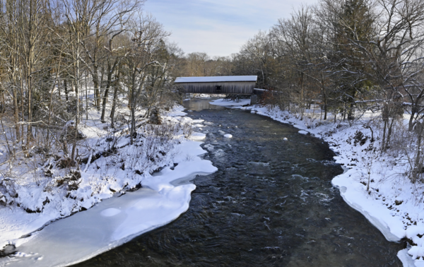
Comstock Covered Bridge Spans Salmon River in East Hampton, Connecticut
Comstock Covered Bridge Spans Salmon River in East Hampton, ConnecticutA USGS monitoring location (Salmon River Near East Hampton, CT - USGS Water Data for the Nation) on the Salmon River is situated near the historic Comstock Covered Bridge.

ADCP measurement via canoe on Connecticut River
Hydrologic technician operates Acoustic Doppler Current Profiler (ADCP) via canoe on Connecticut River.
Hydrologic technician operates Acoustic Doppler Current Profiler (ADCP) via canoe on Connecticut River.

Amphibian research technician with begrudgingly cooperative salamander
Amphibian research technician with begrudgingly cooperative salamanderPhoto Contest | Winter 2022 | Honorable Mention 1
Amphibian research technician with begrudgingly cooperative salamander
Amphibian research technician with begrudgingly cooperative salamander
Amphibian research technician with begrudgingly cooperative salamanderPhoto Contest | Winter 2022 | Honorable Mention 1
Amphibian research technician with begrudgingly cooperative salamander

Aerial view of four vehicles parked on the beach
Photo Contest | Winter 2022 | Honorable Mention 2
Aerial view of four vehicles parked on the beach at Ocracoke Inlet
Photo Contest | Winter 2022 | Honorable Mention 2
Aerial view of four vehicles parked on the beach at Ocracoke Inlet

Robert (Bo) Bales works on a Aquadopp for deployment
Robert (Bo) Bales works on a Aquadopp for deploymentPhoto Contest Winner | September 2021 | People
Robert (Bo) Bales works on a Aquadopp for deployment
Robert (Bo) Bales works on a Aquadopp for deployment
Robert (Bo) Bales works on a Aquadopp for deploymentPhoto Contest Winner | September 2021 | People
Robert (Bo) Bales works on a Aquadopp for deployment

Tidal Marshland in the Plum Island Estuary, Massachusetts
Tidal Marshland in the Plum Island Estuary, MassachusettsThe marshes of Plum Island Estuary are among those predicted by scientists to submerge during the next century under conservative projections of sea-level rise.
Tidal Marshland in the Plum Island Estuary, Massachusetts
Tidal Marshland in the Plum Island Estuary, MassachusettsThe marshes of Plum Island Estuary are among those predicted by scientists to submerge during the next century under conservative projections of sea-level rise.


Carriage road bridge over Duck Brook, Acadia National Park
Carriage road bridge over Duck Brook, Acadia National ParkCarriage road bridge over Duck Brook, Acadia National Park, near Bar Harbor, Maine.
Carriage road bridge over Duck Brook, Acadia National Park
Carriage road bridge over Duck Brook, Acadia National ParkCarriage road bridge over Duck Brook, Acadia National Park, near Bar Harbor, Maine.

Geologists taking field notes
USGS Geologists Jean Self-Trail and Mercer Parker taking field notes, Prince George’s County
USGS Geologists Jean Self-Trail and Mercer Parker taking field notes, Prince George’s County

Paleocene gastropods and bivalve molluscs of the Aquia Formation
Paleocene gastropods and bivalve molluscs of the Aquia FormationA densely packed shell bed of the Paleocene gastropods Kapalmerella mortonii and K. humerosa, along with various bivalve molluscs, King George County, Virginia
Paleocene gastropods and bivalve molluscs of the Aquia Formation
Paleocene gastropods and bivalve molluscs of the Aquia FormationA densely packed shell bed of the Paleocene gastropods Kapalmerella mortonii and K. humerosa, along with various bivalve molluscs, King George County, Virginia

Paleocene bivalve mollusc shells, Aquina Formation, Charles County, Maryland
Paleocene bivalve mollusc shells, Aquina Formation, Charles County, MarylandFossils of the bivalve mollusc Ostrea alepidota from the Paleocene Aquia Formation, Charles County, Maryland.
Paleocene bivalve mollusc shells, Aquina Formation, Charles County, Maryland
Paleocene bivalve mollusc shells, Aquina Formation, Charles County, MarylandFossils of the bivalve mollusc Ostrea alepidota from the Paleocene Aquia Formation, Charles County, Maryland.

Kenna Grubb measuring on the Holston River
Photo Contest Winner | September 2021 | Honorable Mention 1
Kenna Grubb measuring on the Holston River
Photo Contest Winner | September 2021 | Honorable Mention 1
Kenna Grubb measuring on the Holston River

Scientist standing on the beach holding a fish
Scientist standing on the beach holding a fish
October 2021 Region 1 Photo Contest Winner People
Scientist standing on the beach holding a fish
October 2021 Region 1 Photo Contest Winner People