
RAMPS met with DOI Office of Wildland Fire, US Customs and Border Patrol, and US Fish & Wildlife Service staff at Buenos Aires National Wildlife Refuge in southern AZ last November. The group is developing tools to reduce wildfire risk, conserve wildlife habitat and natural resources, and increase safety and security of border operations.
Images
Images described and linked on this webpage come from a wide variety of USGS science activities and presentations performed by USGS Science Center staff members in the Region 7: Upper Colorado Basin. A search tool is provided to narrow the number of image files shown.
Filter Total Items: 548

Managing Fire on the US Mexico Borderlands
RAMPS met with DOI Office of Wildland Fire, US Customs and Border Patrol, and US Fish & Wildlife Service staff at Buenos Aires National Wildlife Refuge in southern AZ last November. The group is developing tools to reduce wildfire risk, conserve wildlife habitat and natural resources, and increase safety and security of border operations.

Sunset from Steamboat Lake, WY
The USGS and partners study the effects of climate change on the Greater Yellowstone Ecosystem. This sunset image was taken from Steamboat Lake, Wind River Indian Reservation, Wind River Range, Wyoming.
The USGS and partners study the effects of climate change on the Greater Yellowstone Ecosystem. This sunset image was taken from Steamboat Lake, Wind River Indian Reservation, Wind River Range, Wyoming.
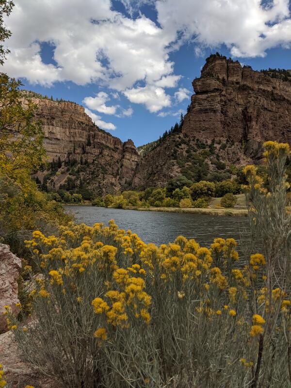
Colorado River at Glenwood Canyon, Colorado
Colorado River with yellow flowers in the foreground and steep canyon walls with visible stratigraphy.
Colorado River with yellow flowers in the foreground and steep canyon walls with visible stratigraphy.

Research raft on Spider Lake, WY
The USGS and partners study the effects of climate change on the Greater Yellowstone Ecosystem. This image shows a research raft on Spider Lake, Wind River Indian Reservation, Wind River Range, Wyoming.
The USGS and partners study the effects of climate change on the Greater Yellowstone Ecosystem. This image shows a research raft on Spider Lake, Wind River Indian Reservation, Wind River Range, Wyoming.

Sealing MBARI Environmental Sample Processor into its housing
Sealing MBARI Environmental Sample Processor into its housingSealing MBARI Environmental Sample Processor into its housing
Sealing MBARI Environmental Sample Processor into its housing
Sealing MBARI Environmental Sample Processor into its housingSealing MBARI Environmental Sample Processor into its housing

Sampling Big Sandy River below Farson, WY
Sampling Big Sandy River below Farson, WY

boulder dropped by retreating glacier in Yellowstone National Park
boulder dropped by retreating glacier in Yellowstone National ParkThis huge boulder was dropped by a retreating glacier on the north rim of the Grand Canyon of the Yellowstone in Yellowstone National Park, and it is a testament to Yellowstone's icy past.
By
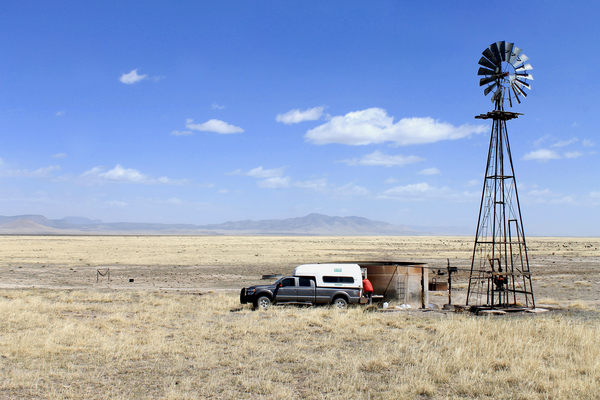
Water quality sampling in the western Plains of San Agustin
Water quality sampling in the western Plains of San AgustinUSGS scientist Mike Carlson works to collect a water quality sample from a windmill in the western Plains of San Agustin. Photo taken by Jeff Pepin on April 10th, 2019.
Water quality sampling in the western Plains of San Agustin
Water quality sampling in the western Plains of San AgustinUSGS scientist Mike Carlson works to collect a water quality sample from a windmill in the western Plains of San Agustin. Photo taken by Jeff Pepin on April 10th, 2019.

Stock tank in the western Plains of San Agustin
USGS scientist Hal Nelson wades in a stock tank to install a fitting on the discharge pipe of a groundwater well to facilitate water quality sampling in the western Plains of San Agustin. Photo taken by Jeff Pepin on April 4th, 2019.
USGS scientist Hal Nelson wades in a stock tank to install a fitting on the discharge pipe of a groundwater well to facilitate water quality sampling in the western Plains of San Agustin. Photo taken by Jeff Pepin on April 4th, 2019.

Wyoming-Montana Stream Water-Quality Network Sites

Gallinas Creek discharge measurement, USGS
Hydrologic Technician Chris Peskuski making a discharge measurement above Gallinas Creek near Montezuma, NM (site data available at: https://waterdata.usgs.gov/nm/nwis/uv?site_no=08380500)
Hydrologic Technician Chris Peskuski making a discharge measurement above Gallinas Creek near Montezuma, NM (site data available at: https://waterdata.usgs.gov/nm/nwis/uv?site_no=08380500)

Swapping precipitation collectors in the Rockies
Daniel Bowker, Loch Vale project manager (2013-18), swapping a clean precipitation collector with a collector from the previous week in Rocky Mountain National Park.
Daniel Bowker, Loch Vale project manager (2013-18), swapping a clean precipitation collector with a collector from the previous week in Rocky Mountain National Park.

Stormwater runoff in the Albuquerque urban area, NMWSC
Stormwater runoff in the Albuquerque urban area, NMWSCStormwater runoff in the Albuquerque urban area, NMWSC
Stormwater runoff in the Albuquerque urban area, NMWSC
Stormwater runoff in the Albuquerque urban area, NMWSCStormwater runoff in the Albuquerque urban area, NMWSC

A USGS scientist prepares a sample to test the effect of antibiotics
A USGS scientist prepares a sample to test the effect of antibioticsA USGS scientist prepares a sample to test the effect of antibiotics on denitrifying bacteria within a glove box. A glove box allows scientists to work with samples in an anaerobic (no oxygen) atmosphere, the conditions under which denitrification occurs.

Leidy Creek near Moran (13012465) streamgage
Leidy Creek near Moran (13012465) streamgage

South Fork Spread Creek near Moran (13012475) streamgage
South Fork Spread Creek near Moran (13012475) streamgageSouth Fork Spread Creek near Moran (13012475) streamgage
South Fork Spread Creek near Moran (13012475) streamgage
South Fork Spread Creek near Moran (13012475) streamgageSouth Fork Spread Creek near Moran (13012475) streamgage

Drainage area contributing to Big Creek below Lookout Creek, nr Apgar
Drainage area contributing to Big Creek below Lookout Creek, nr ApgarDrainage area contributing to Big Creek below Lookout Creek, near Apgar
Drainage area contributing to Big Creek below Lookout Creek, nr Apgar
Drainage area contributing to Big Creek below Lookout Creek, nr ApgarDrainage area contributing to Big Creek below Lookout Creek, near Apgar

RestoreNet garden testing seedling establishment.
The RestoreNet gardens test seedlings of priority restoration species across the Southwest. This is a recently installed garden located in the juniper woodlands of the Colorado Plateau. The experiemental network will support land managers by providing insight into various restoration techniques, including testing seedlings vs seeds.
The RestoreNet gardens test seedlings of priority restoration species across the Southwest. This is a recently installed garden located in the juniper woodlands of the Colorado Plateau. The experiemental network will support land managers by providing insight into various restoration techniques, including testing seedlings vs seeds.

Blacks Fork above Smiths Fork Streamgage
Blacks Fork above Smiths Fork Streamgage

USGS - Roswell Field Office, USGS/BLM
USGS - Roswell Field Office, USGS/BLM
USGS - Roswell Field Office, USGS/BLM

Bear Lake QW Platforms
Technicians deploy water-quality instrumentation on Bear Lake platforms
Technicians deploy water-quality instrumentation on Bear Lake platforms