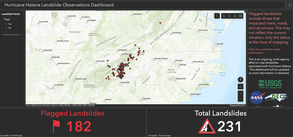
The Landslide Observation Dashboard, a multi-agency effort to map where landslides have occurred in the southern Appalachian Mountains, launched September 30, 2024, as a “timely best science” provisional interface that can be used by the general public and local authorities as they prioritize resources.
Alexandra Hays
(She/Her)Alexandra Hays is a Public Affairs Specialist with the USGS Office of Communications and Publishing representing the Eastern states.
Science and Products
The Landslide Observation Dashboard, a multi-agency effort to map where landslides have occurred in the southern Appalachian Mountains, launched September 30, 2024, as a “timely best science” provisional interface that can be used by the general public and local authorities as they prioritize resources.
U.S. Geological Survey landslide experts conduct an aerial reconnaissance flight October 3, 2024, over the southern Appalachian Mountains to get a better understanding of the extent and severity of landslide impacts in the wake of Hurricane Helene, which brought widespread flooding and destruction. (USGS photo by Ben Mirus).
Tim Fiori, a USGS hydrologic technician, installs a barometric pressure sensor at Venice, Fla., Wednesday, Sept. 25, 2024 ahead of Hurricane Helene's projected landfall in Florida Thursday. (USGS photo by Julie Hobbs)
Tim Fiori, a USGS hydrologic technician, installs a wave sensor at Long Boat Key, Fla., Wednesday, Sept. 25, 2024 ahead of Hurricane Helene's projected landfall in Florida Thursday. (USGS photo by Julie Hobbs)
Julie Hobbs, a USGS hydrologic technician, installs a wave sensor at Long Boat Key, Fla., Wednesday, Sept. 25, 2024 ahead of Hurricane Helene's projected landfall in Florida Thursday. (USGS photo by Tim Fiori)
An image captured from the U.S. Geological Survey's Coastal Change Hazards portal on Sept. 24, 2024, illustrates how much of Florida's west coast is set to experience erosion, overwash, and inundation. (USGS image).
USGS responds to Tropical Storm Debby across Florida, Georgia, North Carolina and South Carolina
linkColette Morris, a U.S. Geological Survey hydrologic technician, takes measurements from a streamgage in Flatford Swamp, Fla., Aug. 7, 2024 just days after Tropical Storm Debby struck Florida's Gulf Coast. (Photo by Don Hampton, USGS).
USGS responds to Tropical Storm Debby across Florida, Georgia, North Carolina and South Carolina
linkMike Ludwig, a U.S. Geological Survey hydrologic technician, reads measurements from a streamgage while sitting on a partially submerged park table in Zephyrhills, Fla., Aug. 7, 2024 just days after Tropical Storm Debby struck Florida's Gulf Coast. (Photo by Todd Dunkle, USGS).
USGS responds to Tropical Storm Debby across Florida, Georgia, North Carolina and South Carolina
linkNick Stanton, a U.S. Geological Survey hydrologic technician, takes floodwater measurements on a road overtopped with water near Parrish, Fla., Aug. 6, 2024 just days after Tropical Storm Debby struck Florida's Gulf Coast. (Photo by Patrick Marasco, USGS).
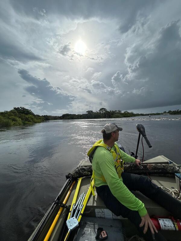
U.S. Geological Survey hydrologic technician Todd Dunkle takes high water measurements with a remote-controlled boat in Clearwater, Fla. Aug. 5, 2024, hours after Tropical Storm Debby made landfall along Florida's western coast. (Photo by Mike Ludwig).
U.S. Geological Survey hydrologic technician Graham Murray installs a rapid deployment gauge Aug. 6, 2024 at Big Reedy Creek near Latta, South Carolina, to measure floodwaters in the wake of Tropical Storm Debby. (USGS photo).
U.S. Geological Survey hydrologic technician Don Hampton traverses Ward Lake in Bradenton, Fla., to take high water measurements on Aug. 6, 2024 in the aftermath of Tropical Storm Debby. (Photo by Vinny Budd, USGS).
Stylized animation showing the shoreline of a wetland that is eroded by waves or currents eating away the sediment along the edge of the wetland. The displaced sediment is then deposited back onto the wetland platform by other waves. When this process happens continually, layers of displaced sediment build up over time, raising the surface of the wetland.
A technician installs strong motion and high frequency sensors April 11 at a station selected to record aftershock data from the April 5, 2024 Whitehouse Station, N.J. earthquake.
U.S. Geological Survey electronics technician Greg Tanner installs an "aftershock kit" in New Jersey April 10 following the April 5, 2024 Whitehouse Station earthquake.
U.S. Geological Survey hydrologic technician Patrick Bowen, foreground, and electronics technician Greg Tanner, background, install an "aftershock kit" in Lawrenceville, N.J., April 9 following the April 5, 2024 Whitehouse Station, N.J. earthquake.
U.S. Geological Survey electronics technician Greg Tanner, left, and Patrick Bowen, a hydrologic technician, install an "aftershock kit" in Lawrenceville, N.J., April 9 following the April 5, 2024 Whitehouse Station, N.J. earthquake.
A cold-stunned green sea turtle near St. Joseph Bay, Florida moments before rescue by U.S. Geological Survey staff members January 23, 2024. The animals were pulled from fatal water temperatures off the coast of Florida and from beaches in a collaborative rescue event by the USGS, Florida Fish and Wildlife Conservation Commission, and the U.S.
Cold-stunned green sea turtles rescued from fatal water temperatures in St. Joseph Bay, Florida by U.S. Geological Survey staff members are held temporarily in a crate before being transferred to Gulf World Marine Institute for rehabilitation and medical treatment January 23, 2024.
An adult female River Cooter, left, and an adult female federally-Threatened Ringed Map Turtle, right, bask in the sun near Covington, Louisiana. (Courtesy photo).
A young federally Threatened Ringed Map Turtle basks on a log near Covington, Louisiana. (Courtesy photo).
2024 Hurricane Helene Landslide Hazards
Science and Products
The Landslide Observation Dashboard, a multi-agency effort to map where landslides have occurred in the southern Appalachian Mountains, launched September 30, 2024, as a “timely best science” provisional interface that can be used by the general public and local authorities as they prioritize resources.
U.S. Geological Survey landslide experts conduct an aerial reconnaissance flight October 3, 2024, over the southern Appalachian Mountains to get a better understanding of the extent and severity of landslide impacts in the wake of Hurricane Helene, which brought widespread flooding and destruction. (USGS photo by Ben Mirus).
Tim Fiori, a USGS hydrologic technician, installs a barometric pressure sensor at Venice, Fla., Wednesday, Sept. 25, 2024 ahead of Hurricane Helene's projected landfall in Florida Thursday. (USGS photo by Julie Hobbs)
Tim Fiori, a USGS hydrologic technician, installs a wave sensor at Long Boat Key, Fla., Wednesday, Sept. 25, 2024 ahead of Hurricane Helene's projected landfall in Florida Thursday. (USGS photo by Julie Hobbs)
Julie Hobbs, a USGS hydrologic technician, installs a wave sensor at Long Boat Key, Fla., Wednesday, Sept. 25, 2024 ahead of Hurricane Helene's projected landfall in Florida Thursday. (USGS photo by Tim Fiori)
An image captured from the U.S. Geological Survey's Coastal Change Hazards portal on Sept. 24, 2024, illustrates how much of Florida's west coast is set to experience erosion, overwash, and inundation. (USGS image).
USGS responds to Tropical Storm Debby across Florida, Georgia, North Carolina and South Carolina
linkColette Morris, a U.S. Geological Survey hydrologic technician, takes measurements from a streamgage in Flatford Swamp, Fla., Aug. 7, 2024 just days after Tropical Storm Debby struck Florida's Gulf Coast. (Photo by Don Hampton, USGS).
USGS responds to Tropical Storm Debby across Florida, Georgia, North Carolina and South Carolina
linkColette Morris, a U.S. Geological Survey hydrologic technician, takes measurements from a streamgage in Flatford Swamp, Fla., Aug. 7, 2024 just days after Tropical Storm Debby struck Florida's Gulf Coast. (Photo by Don Hampton, USGS).
USGS responds to Tropical Storm Debby across Florida, Georgia, North Carolina and South Carolina
linkMike Ludwig, a U.S. Geological Survey hydrologic technician, reads measurements from a streamgage while sitting on a partially submerged park table in Zephyrhills, Fla., Aug. 7, 2024 just days after Tropical Storm Debby struck Florida's Gulf Coast. (Photo by Todd Dunkle, USGS).
USGS responds to Tropical Storm Debby across Florida, Georgia, North Carolina and South Carolina
linkMike Ludwig, a U.S. Geological Survey hydrologic technician, reads measurements from a streamgage while sitting on a partially submerged park table in Zephyrhills, Fla., Aug. 7, 2024 just days after Tropical Storm Debby struck Florida's Gulf Coast. (Photo by Todd Dunkle, USGS).
USGS responds to Tropical Storm Debby across Florida, Georgia, North Carolina and South Carolina
linkNick Stanton, a U.S. Geological Survey hydrologic technician, takes floodwater measurements on a road overtopped with water near Parrish, Fla., Aug. 6, 2024 just days after Tropical Storm Debby struck Florida's Gulf Coast. (Photo by Patrick Marasco, USGS).
USGS responds to Tropical Storm Debby across Florida, Georgia, North Carolina and South Carolina
linkNick Stanton, a U.S. Geological Survey hydrologic technician, takes floodwater measurements on a road overtopped with water near Parrish, Fla., Aug. 6, 2024 just days after Tropical Storm Debby struck Florida's Gulf Coast. (Photo by Patrick Marasco, USGS).
U.S. Geological Survey hydrologic technician Todd Dunkle takes high water measurements with a remote-controlled boat in Clearwater, Fla. Aug. 5, 2024, hours after Tropical Storm Debby made landfall along Florida's western coast. (Photo by Mike Ludwig).
U.S. Geological Survey hydrologic technician Graham Murray installs a rapid deployment gauge Aug. 6, 2024 at Big Reedy Creek near Latta, South Carolina, to measure floodwaters in the wake of Tropical Storm Debby. (USGS photo).
U.S. Geological Survey hydrologic technician Don Hampton traverses Ward Lake in Bradenton, Fla., to take high water measurements on Aug. 6, 2024 in the aftermath of Tropical Storm Debby. (Photo by Vinny Budd, USGS).
Stylized animation showing the shoreline of a wetland that is eroded by waves or currents eating away the sediment along the edge of the wetland. The displaced sediment is then deposited back onto the wetland platform by other waves. When this process happens continually, layers of displaced sediment build up over time, raising the surface of the wetland.
A technician installs strong motion and high frequency sensors April 11 at a station selected to record aftershock data from the April 5, 2024 Whitehouse Station, N.J. earthquake.
U.S. Geological Survey electronics technician Greg Tanner installs an "aftershock kit" in New Jersey April 10 following the April 5, 2024 Whitehouse Station earthquake.
U.S. Geological Survey hydrologic technician Patrick Bowen, foreground, and electronics technician Greg Tanner, background, install an "aftershock kit" in Lawrenceville, N.J., April 9 following the April 5, 2024 Whitehouse Station, N.J. earthquake.
U.S. Geological Survey electronics technician Greg Tanner, left, and Patrick Bowen, a hydrologic technician, install an "aftershock kit" in Lawrenceville, N.J., April 9 following the April 5, 2024 Whitehouse Station, N.J. earthquake.
A cold-stunned green sea turtle near St. Joseph Bay, Florida moments before rescue by U.S. Geological Survey staff members January 23, 2024. The animals were pulled from fatal water temperatures off the coast of Florida and from beaches in a collaborative rescue event by the USGS, Florida Fish and Wildlife Conservation Commission, and the U.S.
Cold-stunned green sea turtles rescued from fatal water temperatures in St. Joseph Bay, Florida by U.S. Geological Survey staff members are held temporarily in a crate before being transferred to Gulf World Marine Institute for rehabilitation and medical treatment January 23, 2024.
An adult female River Cooter, left, and an adult female federally-Threatened Ringed Map Turtle, right, bask in the sun near Covington, Louisiana. (Courtesy photo).
A young federally Threatened Ringed Map Turtle basks on a log near Covington, Louisiana. (Courtesy photo).