
Our coasts, the most familiar part of the ocean are the gateway to the larger deeper ocean world. USGS studies processes and hazards in the coastal zone and how they affect people, wildlife, and ecosystems.
Betsy Boynton (Former Employee)
Science and Products
")
Flyover of the U.S. Coastline (AD)
Our Nation’s coastlines are almost 100,000 miles long. These extensive coastal areas stretch from Maine’s Atlantic shores in the northeast, south along the shores of the Gulf of Mexico and insular areas in the Caribbean. Toward the west, Pacific coastal areas include the shores of California, Oregon and Washington as well as Alaska, Hawai’i and insular areas in the Pacific Islands. The Nation’s...

USGS Ocean Research
Our coasts, the most familiar part of the ocean are the gateway to the larger deeper ocean world. USGS studies processes and hazards in the coastal zone and how they affect people, wildlife, and ecosystems.

Coasts, Estuaries, Wetlands, and Marshes
Photograph collage representing different coastlines; permafrost coasts, sandy beaches, rocky beaches, wetlands and marshes, cliff-backed beaches, and estuaries.
Photograph collage representing different coastlines; permafrost coasts, sandy beaches, rocky beaches, wetlands and marshes, cliff-backed beaches, and estuaries.

Marsh lateral shoreline erosion and shore-proximal sediment deposition
Marsh lateral shoreline erosion and shore-proximal sediment depositionSalt marshes provide important economic and ecologic services but are vulnerable to habitat loss, particularly due to shoreline erosion from storms and sea level rise. Sediments eroded at the marsh edge are either delivered onto the marsh platform or into the estuary, the latter resulting in a net loss to the marsh sediment budget and released soil carbon.
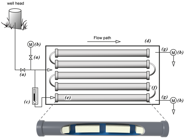
Above ground mesocosm with biofilm growth reactors
Above ground mesocosm with biofilm growth reactorsAbove ground mesocosm with biofilm growth reactors. Groundwater from the well head is directly transferred to the mesocosm via PTFE tubing into a high flow rate control valve (a) that diverts groundwater into a flow cell containing a water quality measurement meter (b) and a low flow control valve (c).

Sea level rise scenario model for Dauphin Island, Alabama
Sea level rise scenario model for Dauphin Island, AlabamaThis model shows what Dauphin Island, Alabama, may look like under moderate storms but with increasing rates of sea level rise (Passeri and others, 2018).
Sea level rise scenario model for Dauphin Island, Alabama
Sea level rise scenario model for Dauphin Island, AlabamaThis model shows what Dauphin Island, Alabama, may look like under moderate storms but with increasing rates of sea level rise (Passeri and others, 2018).
Storm and sea level rise scenario model for Dauphin Island, Alabama
Storm and sea level rise scenario model for Dauphin Island, AlabamaStorm and sea level rise scenario models, like the one shown here, can be used to explore the future. This model shows what Dauphin Island may look like 10 years from now if storms become stronger and more frequent (Passeri and others, 2018).

Summer internships at St. Pete
Summer intern Katie Krueger (center) and her USGS supervisors: research oceanographer Lisa Robbins (left) and research geologist Jennifer Miselis. Because of her stellar academics and volleyball skills, Krueger was notified of her acceptance to Virginia Tech early in her junior year.
Summer intern Katie Krueger (center) and her USGS supervisors: research oceanographer Lisa Robbins (left) and research geologist Jennifer Miselis. Because of her stellar academics and volleyball skills, Krueger was notified of her acceptance to Virginia Tech early in her junior year.

Ocean Acidification: Research on Top of the World
The Arctic Ocean is one of the most unique bodies of water on the planet. It houses large charismatic predators like polar bears, whales, and seals; critical species like shell fish and phytoplankton; and an array of organisms found nowhere else on Earth. The Arctic Ocean is also the most inaccessible and least explored ocean.
The Arctic Ocean is one of the most unique bodies of water on the planet. It houses large charismatic predators like polar bears, whales, and seals; critical species like shell fish and phytoplankton; and an array of organisms found nowhere else on Earth. The Arctic Ocean is also the most inaccessible and least explored ocean.

Microfossils Reveal Climatic History of the Gulf of Mexico
Microfossils Reveal Climatic History of the Gulf of MexicoProxy data such as tree rings, ice cores, and microorganisms are collected and analyzed by scientists to unlock past climate records stretching back thousands to millions of years ago. This video podcast examines how scientists can decipher past climate from such records by focusing on a proxy calibration study in the Gulf of Mexico. Microfossils recover

Corals: A 50-Year Photographic Record of Changes
This video podcast highlights 50 years of photographic documentation of coral reefs in the Florida Keys. The photographs show 5 decades of changes that have taken place in both the size and the types of corals that were present at several coral reef sites from the early 1960s to today. The images capture events such as the appearance of coral disease and
This video podcast highlights 50 years of photographic documentation of coral reefs in the Florida Keys. The photographs show 5 decades of changes that have taken place in both the size and the types of corals that were present at several coral reef sites from the early 1960s to today. The images capture events such as the appearance of coral disease and

African Dust, Coral Reefs and Human Health
This documentary presents how recent changes in the composition and quantities of African dust transported to the Caribbean and the Americas might provide clues to why Caribbean coral reef ecosystems are deteriorating and human health may be impacted.
This documentary presents how recent changes in the composition and quantities of African dust transported to the Caribbean and the Americas might provide clues to why Caribbean coral reef ecosystems are deteriorating and human health may be impacted.
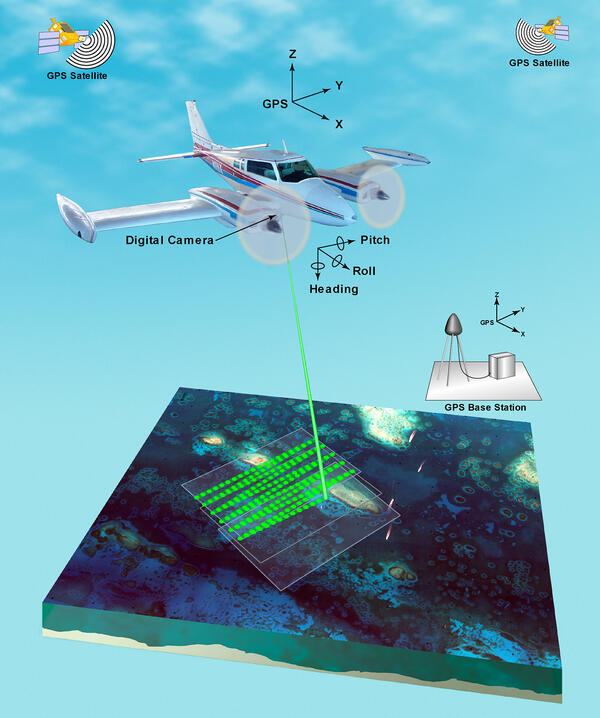
Illustration of airborne lidar acquisition platform
Illustration of airborne lidar acquisition platformAirborne lidar is a surveying method that measures distance to a target from a survey plane by illuminating that target with a pulsed laser light, and measuring the reflected pulses with a sensor. Differences in laser return times and wavelengths can then be used to make digital 3D-representations of the target.

Lidar plane
Airborne lidar is a surveying method that measures distance to a target from a survey plane by illuminating that target with a pulsed laser light, and measuring the reflected pulses with a sensor. Differences in laser return times and wavelengths can then be used to make digital 3D-representations of the target.
Airborne lidar is a surveying method that measures distance to a target from a survey plane by illuminating that target with a pulsed laser light, and measuring the reflected pulses with a sensor. Differences in laser return times and wavelengths can then be used to make digital 3D-representations of the target.
Science and Products
Flyover of the U.S. Coastline (AD)
Our Nation’s coastlines are almost 100,000 miles long. These extensive coastal areas stretch from Maine’s Atlantic shores in the northeast, south along the shores of the Gulf of Mexico and insular areas in the Caribbean. Toward the west, Pacific coastal areas include the shores of California, Oregon and Washington as well as Alaska, Hawai’i and insular areas in the Pacific Islands. The Nation’s...
USGS Ocean Research
Our coasts, the most familiar part of the ocean are the gateway to the larger deeper ocean world. USGS studies processes and hazards in the coastal zone and how they affect people, wildlife, and ecosystems.
Our coasts, the most familiar part of the ocean are the gateway to the larger deeper ocean world. USGS studies processes and hazards in the coastal zone and how they affect people, wildlife, and ecosystems.
Coasts, Estuaries, Wetlands, and Marshes
Photograph collage representing different coastlines; permafrost coasts, sandy beaches, rocky beaches, wetlands and marshes, cliff-backed beaches, and estuaries.
Photograph collage representing different coastlines; permafrost coasts, sandy beaches, rocky beaches, wetlands and marshes, cliff-backed beaches, and estuaries.
Marsh lateral shoreline erosion and shore-proximal sediment deposition
Marsh lateral shoreline erosion and shore-proximal sediment depositionSalt marshes provide important economic and ecologic services but are vulnerable to habitat loss, particularly due to shoreline erosion from storms and sea level rise. Sediments eroded at the marsh edge are either delivered onto the marsh platform or into the estuary, the latter resulting in a net loss to the marsh sediment budget and released soil carbon.
Above ground mesocosm with biofilm growth reactors
Above ground mesocosm with biofilm growth reactorsAbove ground mesocosm with biofilm growth reactors. Groundwater from the well head is directly transferred to the mesocosm via PTFE tubing into a high flow rate control valve (a) that diverts groundwater into a flow cell containing a water quality measurement meter (b) and a low flow control valve (c).
Sea level rise scenario model for Dauphin Island, Alabama
Sea level rise scenario model for Dauphin Island, AlabamaThis model shows what Dauphin Island, Alabama, may look like under moderate storms but with increasing rates of sea level rise (Passeri and others, 2018).
Sea level rise scenario model for Dauphin Island, Alabama
Sea level rise scenario model for Dauphin Island, AlabamaThis model shows what Dauphin Island, Alabama, may look like under moderate storms but with increasing rates of sea level rise (Passeri and others, 2018).
Storm and sea level rise scenario model for Dauphin Island, Alabama
Storm and sea level rise scenario model for Dauphin Island, AlabamaStorm and sea level rise scenario models, like the one shown here, can be used to explore the future. This model shows what Dauphin Island may look like 10 years from now if storms become stronger and more frequent (Passeri and others, 2018).
Summer internships at St. Pete
Summer intern Katie Krueger (center) and her USGS supervisors: research oceanographer Lisa Robbins (left) and research geologist Jennifer Miselis. Because of her stellar academics and volleyball skills, Krueger was notified of her acceptance to Virginia Tech early in her junior year.
Summer intern Katie Krueger (center) and her USGS supervisors: research oceanographer Lisa Robbins (left) and research geologist Jennifer Miselis. Because of her stellar academics and volleyball skills, Krueger was notified of her acceptance to Virginia Tech early in her junior year.
Ocean Acidification: Research on Top of the World
The Arctic Ocean is one of the most unique bodies of water on the planet. It houses large charismatic predators like polar bears, whales, and seals; critical species like shell fish and phytoplankton; and an array of organisms found nowhere else on Earth. The Arctic Ocean is also the most inaccessible and least explored ocean.
The Arctic Ocean is one of the most unique bodies of water on the planet. It houses large charismatic predators like polar bears, whales, and seals; critical species like shell fish and phytoplankton; and an array of organisms found nowhere else on Earth. The Arctic Ocean is also the most inaccessible and least explored ocean.
Microfossils Reveal Climatic History of the Gulf of Mexico
Microfossils Reveal Climatic History of the Gulf of MexicoProxy data such as tree rings, ice cores, and microorganisms are collected and analyzed by scientists to unlock past climate records stretching back thousands to millions of years ago. This video podcast examines how scientists can decipher past climate from such records by focusing on a proxy calibration study in the Gulf of Mexico. Microfossils recover
Corals: A 50-Year Photographic Record of Changes
This video podcast highlights 50 years of photographic documentation of coral reefs in the Florida Keys. The photographs show 5 decades of changes that have taken place in both the size and the types of corals that were present at several coral reef sites from the early 1960s to today. The images capture events such as the appearance of coral disease and
This video podcast highlights 50 years of photographic documentation of coral reefs in the Florida Keys. The photographs show 5 decades of changes that have taken place in both the size and the types of corals that were present at several coral reef sites from the early 1960s to today. The images capture events such as the appearance of coral disease and
African Dust, Coral Reefs and Human Health
This documentary presents how recent changes in the composition and quantities of African dust transported to the Caribbean and the Americas might provide clues to why Caribbean coral reef ecosystems are deteriorating and human health may be impacted.
This documentary presents how recent changes in the composition and quantities of African dust transported to the Caribbean and the Americas might provide clues to why Caribbean coral reef ecosystems are deteriorating and human health may be impacted.
Illustration of airborne lidar acquisition platform
Illustration of airborne lidar acquisition platformAirborne lidar is a surveying method that measures distance to a target from a survey plane by illuminating that target with a pulsed laser light, and measuring the reflected pulses with a sensor. Differences in laser return times and wavelengths can then be used to make digital 3D-representations of the target.
Lidar plane
Airborne lidar is a surveying method that measures distance to a target from a survey plane by illuminating that target with a pulsed laser light, and measuring the reflected pulses with a sensor. Differences in laser return times and wavelengths can then be used to make digital 3D-representations of the target.
Airborne lidar is a surveying method that measures distance to a target from a survey plane by illuminating that target with a pulsed laser light, and measuring the reflected pulses with a sensor. Differences in laser return times and wavelengths can then be used to make digital 3D-representations of the target.