
Jesslyn Brown
Jesslyn Brown is a research geographer with the U.S. Geological Survey (USGS) Earth Resources Observation and Science (EROS) Center in Sioux Falls, South Dakota, USA. Jess's main interests involve improving the understanding of changes in terrestrial vegetation, drought early warning, and transitions in land cover and land use by advancing the use of remote sensing imagery in applications.
Jesslyn Brown is a research geographer with the U.S. Geological Survey (USGS) Earth Resources Observation and Science (EROS) Center in Sioux Falls, South Dakota, USA, where she has worked over 30 years. Her work in applied geographic research has contributed to improving understanding of terrestrial vegetation patterns and advancing the use of remotely sensed imagery for applications including drought early warning, tracking vegetation phenology (i.e., seasonal dynamics), and mapping land cover and land use. In the 1990s, Jess was a member of the Global Land Cover Characteristics team that created the first map of global land cover at a 1-km resolution. From 2001 to 2017, she led multiple projects mainly focused on developing new monitoring tools, including VegDRI and QuickDRI, to improve agricultural drought monitoring capabilities in the U.S. in a strong collaboration with the University of Nebraska-Lincoln’s National Drought Mitigation Center. During that time, she also led efforts to investigate recent land use change specifically focused on irrigated agriculture across the country. In 2017, she began leading the Land Change Monitoring Assessment and Projection (LCMAP) science team. LCMAP was a USGS initiative to develop an end-to-end capability to use the deep Landsat record to continuously track and characterize changes in land cover state and condition and translate the information into assessments of current and historical processes of cover and change. In 2023, the LCMAP project was integrated with the National Land Cover Database team. Under Jess’s leadership, this team developed and produced a new annual land cover database for the conterminous U.S. covering 39 years from 1985 to 2023 utilizing the long Landsat record, deep learning methods, and cloud computing.
Science and Products
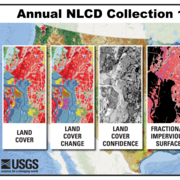
Annual NLCD Product Suite

Annual NLCD Data Access

About Annual NLCD

Reference and Validation

Annual National Land Cover Database

Multi-resolution Land Cover Characterization Consortium
Science and Products
Annual NLCD Product Suite
Annual NLCD Data Access
About Annual NLCD
Reference and Validation
Annual National Land Cover Database