
Kurt McCoy
Kurt McCoy has been employed as a hydrologist with the US Geological Survey since 2002. Kurt has worked on aquifer studies in a number of states including West Virginia, Pennsylvania, Wyoming, New Mexico, and Virginia.
My group focuses on facilitating and communicating science to inform coastal communities facing flooding risks from sea-level rise and assisting rural communities with water resource availability needs. I actively encourage participation in collaborative teams with a wide range of scientists, and specifically look for or seek to build collaborative opportunities for my team members to advance their respective interests. Some recent examples include subsidence monitoring in the Chesapeake Bay to support ecological modeling of marsh habitat, seismic modeling of waste water injection, induced PFAS transport from surface water sources, and UAS monitoring of ecological change in coastal environments.
Science and Products

Accessing Water Use Data

Water Use in the United States

Withdrawals for Bottled Water

Water Cycle Center

New Crowd Sourcing Will Contribute to Study of Land Subsidence and Sea-Level Rise in the Chesapeake Bay

Tripod-palooza—USGS Collaborates with Federal, State, and Academic Partners to Support Coastal Resiliency in the Wider Chesapeake Bay Area
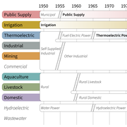
Changes in Water Use Categories

Appalachian Plateau Groundwater Availablity Study

Bedford County Water Monitoring Network

Virginia Beach Shallow Groundwater Resources
Science and Products
Accessing Water Use Data
Water Use in the United States
Withdrawals for Bottled Water
Water Cycle Center
New Crowd Sourcing Will Contribute to Study of Land Subsidence and Sea-Level Rise in the Chesapeake Bay
Tripod-palooza—USGS Collaborates with Federal, State, and Academic Partners to Support Coastal Resiliency in the Wider Chesapeake Bay Area
Changes in Water Use Categories
Appalachian Plateau Groundwater Availablity Study
Bedford County Water Monitoring Network