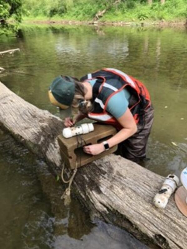
The Landslide Observation Dashboard, a multi-agency effort to map where landslides have occurred in the southern Appalachian Mountains, launched September 30, 2024, as a “timely best science” provisional interface that can be used by the general public and local authorities as they prioritize resources.
Images

The Landslide Observation Dashboard, a multi-agency effort to map where landslides have occurred in the southern Appalachian Mountains, launched September 30, 2024, as a “timely best science” provisional interface that can be used by the general public and local authorities as they prioritize resources.

U.S. Geological Survey landslide experts conduct an aerial reconnaissance flight October 3, 2024, over the southern Appalachian Mountains to get a better understanding of the extent and severity of landslide impacts in the wake of Hurricane Helene, which brought widespread flooding and destruction. (USGS photo by Ben Mirus).

USGS Hydrologic Technician Pamela Loftin looks on at the aftermath of severe flooding on Pigeon River in Newport, Tennessee. USGS crews were onsite October 1 to measure high-water marks to determine how high the flood waters reached at this location. Photo by Logan Combs, USGS.
Students participating in Tennessee State University's Summer Apprenticeship Program process water samples in a laboratory during the 2024 cohort. (Courtesy photo).
Andrea Jaegge, far left, a USGS postdoctoral biologist, instructs Tennessee State University students participating in the school's 2024 cohort of the Summer Apprenticeship Program, on how to use a epifluorescent microscope to view algae (Courtesy photo).
Thomas Byl, far left, a U.S. Geological Survey biologist and professor at Tennessee State University, poses with a group of TSU's Summer Apprenticeship Program students as they prepare to do some wetlands science. (Courtesy photo).
Students participating in the 2024 cohort of Tennessee State University's Summer Apprenticeship Program take a field trip to Mammoth Cave National Park, Kentucky. (Courtesy photo).
Devin Moore, left, a U.S. Geological Survey intern and Tennessee State University graduate student, assists a 2024 TSU Summer Apprenticeship Program participant in wetlands research. (Courtesy photo).
U.S. Geological Survey biologist Thomas Byl, foreground, leads students participating in Tennessee State University's 2024 cohort of the Summer Apprenticeship Program. (Courtesy photo).
Kristin Hill stands tall in the foreground, her gaze fixed on the horizon. Her confident posture and determined expression speak volumes about her adventurous spirit. She's clearly prepared for the challenge ahead, outfitted in practical hiking gear: sturdy boots grip the rocky terrain, a backpack rests comfortably on her shoulders.
A group of words put together in vertical and horizontal positions to form a word cloud, that describe employment opportunities with the USGS.

Map showing principal aquifers (PAs) and wells that were sampled as part of a Nationwide assessment of the quality of groundwater used for public supply.

Recently USGS hydrologists installed equipment to measure changes in groundwater levels over time at this well in Cordell Hull Birthplace State Park in Tennessee. While new groundwater wells used for household water supplies in the United States are now usually installed using modern drilling equipment, this old well was originally dug by hand.

TNMCorps Mapping Challenge: Cemeteries in Western TN with a FINISHED stamp
Tennessee has had several nicknames, but the most popular is the “Volunteer State.” The nickname originated during the War of 1812 when volunteer soldiers from Tennessee displayed marked valor in the Battle of New Orleans.
Capital Nashville
Image Source Landsat 8
Tennessee has had several nicknames, but the most popular is the “Volunteer State.” The nickname originated during the War of 1812 when volunteer soldiers from Tennessee displayed marked valor in the Battle of New Orleans.
Capital Nashville
Image Source Landsat 8
This is a graphic from the USGS National Oil and Gas Assessment Explorer application, which allows user to drill into 70 oil and gas assessment provinces throughout the United States.
Conglomerates within the Sycamore Sand at Hammetts Crossing, Travis County, Texas (photograph by Allan K. Clark, U.S. Geological Survey, February 27, 2018).
U.S. Geological Survey Scientific Investigations Map 3418, https://doi.org/10.3133/sim3418
Conglomerates within the Sycamore Sand at Hammetts Crossing, Travis County, Texas (photograph by Allan K. Clark, U.S. Geological Survey, February 27, 2018).
U.S. Geological Survey Scientific Investigations Map 3418, https://doi.org/10.3133/sim3418
Ocoee River, Tennessee
A wooded area of Tennessee shows different varieties of trees in various stages of fall's changing leaf colors. Some are in red, orange, yellow, and green and contrast with dark tree trunks. A dark green rhododendron is in the left foreground; a mountain and cloudy blue skies are barely visible in the distance through the trees.
An Appalachian Mountain Stream in the Spring. Photographed by Samuel H Austin

Panoramic view (~270 degrees) looking across the Blue Ridge of Virginia, North Carolina and Tennessee (from left to right). The Valley and Ridge is in the distance (gap between mountains).