
Interactive Map: Virginia and West Virginia Groundwater Levels and Trends
View current groundwater levels and long-term trends for continuous groundwater monitoring locations across Virginia and West Virginia.
Virginia and West Virginia Monitoring Networks
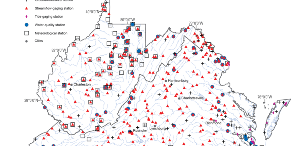
The Virginia and West Virginia Water Science Center maintains multiple networks of groundwater and surface water monitoring sites. Explore our monitoring networks and download surface water, groundwater, and water quality monitoring data for active sites using our monitoring network mapper.
Current Water Conditions Across the Nation

Interested in current conditions elsewhere? The National Water Dashboard provides real-time streamflow, groundwater, and water-quality conditions and access to data for all active monitoring sites across the the Nation.
About this Tool
The Virginia and West Virginia Groundwater Levels and Trends web application provides access to groundwater level data from continuous groundwater wells across Virginia and West Virginia. Recent water-level measurements for all wells considered are compared to long-term monthly statistics using functions in the HASP R Package. Wells are classified and visualized according to water-level conditions relative to long-term monthly statistics.

For each well, additional information and links to the real time data in Water Data for the Nation is provided on detailed site pages accessible through the pop-up information in the map and in the Network Well List at the bottom of the page. The information on this page updates daily, though some continuous measurements can be as frequent as every five minutes.
Unprocessed groundwater level data are always available on Water Data For the Nation. This website is the best place to get the most recent, uninterpreted data and will include provisional data not shown in this application. It contains water resources data collected from approximately 1.9 million sites in all 50 states, the District of Columbia, Puerto Rico, the Virgin Islands, Guam, American Samoa and the Commonwealth of the Northern Mariana Islands.
Visit usgs.gov/gwsip to learn more about groundwater monitoring efforts by the USGS and partners.
Related
Explore U.S. Geological Survey science related to groundwater and drought monitoring, groundwater quality, and water use.

PFAS in West Virginia's Groundwater and Surface Water

Land Subsidence on the Virginia Coastal Plain

Virginia Eastern Shore Groundwater Resources
Related
Explore U.S. Geological Survey science related to groundwater and drought monitoring, groundwater quality, and water use.
PFAS in West Virginia's Groundwater and Surface Water
Land Subsidence on the Virginia Coastal Plain