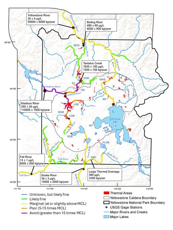
U.S. flag

An official website of the United States government

Images

Images of Yellowstone.

Filter Total Items: 681
Map of Yellowstone showing the location of seismic stations YSB and YUF as well as streamgages at Lamar River (LRG) and the Yellowstone River (YRG)

Map of Yellowstone showing the location of seismic stations YSB and YUF (yellow triangles) as well as the stream gages (red triangles) at Lamar River (LRG) and the Yellowstone River (YRG) at the outlet of Yellowstone Lake.

Discharge data from the Lamar River (red line) compared to seismic data recorded at station YSB in June 2022
Front cover of the Yellowstone Volcano Observatory’s Volcano and Earthquake Monitoring Plan for the Yellowstone Caldera System, 2022–2032
SNOTEL and streamgage sites in and around Yellowstone National Park

Map of SNOTEL snowpack telemetry sites (blue dots) and streamgages (red dots) in and around Yellowstone National Park.

Yellowstone River level and discharge during June 9–16, 2022, at Corwin Springs streamgage north of Yellowstone National Park

Yellowstone River level (left) and discharge (right) during June 9–16, 2022, measured at the Corwin Springs streamgage just north of Yellowstone National Park (https://waterdata.usgs.gov/mt/nwis/uv/?site_no=06191500&PARAmeter_cd=00065,00060,00010).  The

Outcrop of the Tuff of Lost Creek near Sepulcher Mountain in Yellowstone National Park
Tuff of Lost Creek near Sepulcher Mountain, Yellowstone National Park

Outcrop of the Tuff of Lost Creek near Sepulcher Mountain in Yellowstone National Park.  Photo by Natalie Kraugh, Montana State University, on June 8, 2022.

Photograph of the west side of Mount Everts taken from Sepulcher Mountain
West side of Mount Everts from Sepulcher Mountain

Photograph of the west side of Mount Everts taken from Sepulcher Mountain. The linear features seen on the western face are sedimentary rocks running north to south. (Photo by Jess Condon, June 8, 2022)

Photograph of the west side of Mount Everts taken from Sepulcher Mountain. The linear features seen on the western face are sedimentary rocks running north to south. (Photo by Jess Condon, June 8, 2022)

Route of the Nez Perce in 1877

Route followed by a band of Nez Perce (or, in their language, Nimiipu or Nee-Me-Poo) in 1877.

Steamboat Geyser erupting on 23 May 2022

Steamboat Geyser erupting on 23 May 2022. Dead and downed trees can be seen in the foreground. Photo by Mara Reed, UC Berkeley, May 23, 2022.

Steamboat Geyser erupting on 23 May 2022. Dead and downed trees can be seen in the foreground. Photo by Mara Reed, UC Berkeley, May 23, 2022.

Scientists install a semipermanent GPS station in Yellowstone National Park

Scientists install a semipermanent GPS station in Yellowstone National Park.  These stations, which are not radio-telemetered, are typically installed in May and recovered in October, when the data are downloaded and processed.  These stations help to supplement the continuous GPS network in the Yellowstone area.

Scientists install a semipermanent GPS station in Yellowstone National Park.  These stations, which are not radio-telemetered, are typically installed in May and recovered in October, when the data are downloaded and processed.  These stations help to supplement the continuous GPS network in the Yellowstone area.

Yellowstone Volcano Observatory biennial meeting in May 2022

Scientists and collaborators of the Yellowstone Volcano Observatory meet in Mammoth Hot Springs in May 2022 to discuss the protocols for responding to a geological event in Yellowstone National Park.

Scientists and collaborators of the Yellowstone Volcano Observatory meet in Mammoth Hot Springs in May 2022 to discuss the protocols for responding to a geological event in Yellowstone National Park.

Mammoth Hot Springs Hotel, Yellowstone National Park

Mammoth Hot Springs Hotel in Yellowstone National Park, where Yellowstone Volcano Observatory scientists met in May 2022 to discuss recent scientific results and to revise the Observatory's plan for responding to geological unrest.

Mammoth Hot Springs Hotel in Yellowstone National Park, where Yellowstone Volcano Observatory scientists met in May 2022 to discuss recent scientific results and to revise the Observatory's plan for responding to geological unrest.

YVO scientist replaces batteries in a temperature logger (Norris Basin)
Yellowstone Volcano Observatory scientist-in-charge Mike Poland replaces batteries in a temperature logger in Norris Geyser Basin.
Annie Carlson, Research Permitting Coordinator for Yellowstone National Park during 2017–2023
Cathodoluminescence images of zircon mineral grains from an Archean-age rock found in the Yellowstone region

Cathodoluminescence images generated by the interaction of electromagnetic radiation ranging in energy from ultraviolet to near infrared with sectioned and polished zircon mineral grains from an Archean-age rock found in the Yellowstone region.

Cover of Yellowstone Volcano Observatory 2021 Annual Report

Front cover of the Yellowstone Volcano Observatory 2021 annual report, which includes a summary of earthquake, deformation, and geyser activity, as well as research investigations and other information. The report is freely available online at https://pubs.er.usgs.gov/publication/cir1494.

Front cover of the Yellowstone Volcano Observatory 2021 annual report, which includes a summary of earthquake, deformation, and geyser activity, as well as research investigations and other information. The report is freely available online at https://pubs.er.usgs.gov/publication/cir1494.

Color-shaded bathymetric map of Yellowstone Lake showing locations of sediment cores and major tectonic features
Color-shaded bathymetric map of Yellowstone Lake

Color-shaded bathymetric map of Yellowstone Lake showing locations of sediment cores and major tectonic features (faults, fractures, lineaments, caldera margins) and hydrothermal areas (vents, domes, hydrother­mal explosion craters).

Color-shaded bathymetric map of Yellowstone Lake showing locations of sediment cores and major tectonic features (faults, fractures, lineaments, caldera margins) and hydrothermal areas (vents, domes, hydrother­mal explosion craters).

Map of Two Ocean Pass and the Parting of the Waters

Map of Two Ocean Pass and the Parting of the Waters. Pacific Creek flows southwest toward the Snake River, and Atlantic Creek flows northeast toward the Yellowstone River. The green line is the Continental Divide.

Map of Two Ocean Pass and the Parting of the Waters. Pacific Creek flows southwest toward the Snake River, and Atlantic Creek flows northeast toward the Yellowstone River. The green line is the Continental Divide.

Was this page helpful?