
Flagg Ranch exposure showing lower unknown ignimbrite (ash flow), the Lava Creek Tuff (LCT) ash fall deposit, and upper ignimbrite of the LCT. Thanks to work by Montana State University geologists, it is now known that the unknown ignimbrite was deposited immediately prior to the ash fall, with no significant time gap in between.
Images
Images of Yellowstone.
Filter Total Items: 725

Flagg Ranch exposure of the Lava Creek Tuff
Flagg Ranch exposure showing lower unknown ignimbrite (ash flow), the Lava Creek Tuff (LCT) ash fall deposit, and upper ignimbrite of the LCT. Thanks to work by Montana State University geologists, it is now known that the unknown ignimbrite was deposited immediately prior to the ash fall, with no significant time gap in between.

Flagg Ranch exposure of the Lava Creek Tuff with quartz-hosted melt inclusions
Flagg Ranch exposure of the Lava Creek Tuff with quartz-hosted melt inclusionsPhoto of ash-fall deposit of the Lava Creek Tuff overlying the lower “unknown” ignimbrite (an ash-flow unit, denoted by light yellow box). Images of quartz-hosted melt inclusions show fully “baked” (dark) melt inclusions in the lowest ash fall layers (1–2).

Regional shaded relief map of the Eastern Snake River Plain
Regional shaded relief map of the Eastern Snake River PlainRegional shaded relief map of the Eastern Snake River Plain (ESRP). The map highlights the low relief terrain of the ESRP and the dramatic rhyolite domes that punctuate it. Map by Zach Lifton, Idaho Geological Survey.

Scanning electron microscope (SEM) photograph of a diatom on a lodgepole pine needle from Upper Geyser Basin, Yellowstone National Park
Scanning electron microscope (SEM) photograph of a diatom on a lodgepole pine needle from Upper Geyser Basin, Yellowstone National ParkScanning electron microscope (SEM) photograph of a diatom on a lodgepole pine needle from Upper Geyser Basin. A 10 micrometer (µm) scale is shown at the bottom of the image (slightly less than the width of human hair).

River levels and vertical deformation of Yellowstone caldera during 2016–2022
River levels and vertical deformation of Yellowstone caldera during 2016–2022River levels and vertical deformation of Yellowstone caldera during 2016–2022. River level (blue) was measured at the Corwin Springs gaging station on the Yellowstone River, just north of Yellowstone National Park. Vertical deformation (red) is from the WLWY GPS station on the east side of Yellowstone caldera. The GPS data indicate overall subsiden
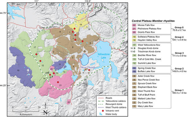
Map of Yellowstone caldera showing the locations and ages of the Central Plateau Member rhyolites
Map of Yellowstone caldera showing the locations and ages of the Central Plateau Member rhyolitesMap of Yellowstone caldera showing the locations and ages of the most recent rhyolite eruptions at Yellowstone, the Central Plateau Member rhyolites. Unit boundaries are from Christiansen (2001).

Bison in Yellowstone National Park
Bison in Yellowstone National Park. USGS photo by Jennifer Lewicki, September 20, 2023.
Bison in Yellowstone National Park. USGS photo by Jennifer Lewicki, September 20, 2023.

Grand Prismatic Spring
A view of the Grand Prismatic Hot Spring from the vantage point of the Grand Prismatic Overlook Trail in Yellowstone National Park, Wyoming.
A view of the Grand Prismatic Hot Spring from the vantage point of the Grand Prismatic Overlook Trail in Yellowstone National Park, Wyoming.

Rainbow over Ledge Geyser
A rainbow rises over Ledge Geyser in Yellowstone National Park, Wyoming. "Ledge is the second largest geyser in the Norris Geyser Basin, capable of shooting water 125 feet into the air. Because it erupts at an angle, however, the water will sometimes reach the ground 220 feet away." - NPS
A rainbow rises over Ledge Geyser in Yellowstone National Park, Wyoming. "Ledge is the second largest geyser in the Norris Geyser Basin, capable of shooting water 125 feet into the air. Because it erupts at an angle, however, the water will sometimes reach the ground 220 feet away." - NPS

Castle Geyser
A view of Castle Geyser erupting as a rainbow rises out and over the eruption. Castle Geyser is located in the Upper Geyser Basin of Yellowstone National Park, Wyoming.
A view of Castle Geyser erupting as a rainbow rises out and over the eruption. Castle Geyser is located in the Upper Geyser Basin of Yellowstone National Park, Wyoming.

Old Faithful
The famous Old Faithful geyser begins an eruption as visitors watch in the distance. This view is looking from Beehive Geyser toward Old Faithful.
The famous Old Faithful geyser begins an eruption as visitors watch in the distance. This view is looking from Beehive Geyser toward Old Faithful.

Ear Spring
"Ear Spring is a truly hot spring, with surface water temperatures often above the boiling point of 198°F (92°C) at this elevation. True to its name, this pool is shaped somewhat like an ear." - NPS
"Ear Spring is a truly hot spring, with surface water temperatures often above the boiling point of 198°F (92°C) at this elevation. True to its name, this pool is shaped somewhat like an ear." - NPS

Beehive Geyser
An explosive eruption of silica water erupts from Beehive Geyser located in the Upper Geyser Basin in Yellowstone National Park, Wyoming. The Upper Geyser Basin is also home to the famous Old Faithful geyser which sits just behind Beehive Geyser in the distance.
An explosive eruption of silica water erupts from Beehive Geyser located in the Upper Geyser Basin in Yellowstone National Park, Wyoming. The Upper Geyser Basin is also home to the famous Old Faithful geyser which sits just behind Beehive Geyser in the distance.

Yellowstone River from Brink of Lower Falls
Looking down from the lookout point at Brink of Lower Falls, over the Yellowstone River, as it flows south into the distance.
Looking down from the lookout point at Brink of Lower Falls, over the Yellowstone River, as it flows south into the distance.
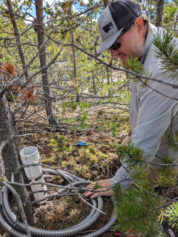
Infrasound sensor installation at Norris Geyser Basin
Infrasound sensor installation at Norris Geyser BasinDr.

Early Morning on the Gibbon River
A foggy, early morning view looking down the Gibbon River, off of Grand Loop Rd in Yellowstone National Park, Wyoming.
A foggy, early morning view looking down the Gibbon River, off of Grand Loop Rd in Yellowstone National Park, Wyoming.

Yellowstone River from Brink of Lower Falls
Looking down from the lookout point at Brink of Lower Falls, over the Yellowstone River, as it flows eastward through the "Grand Canyon of Yellowstone".
Looking down from the lookout point at Brink of Lower Falls, over the Yellowstone River, as it flows eastward through the "Grand Canyon of Yellowstone".

Silver Gate - Travertine
On the drive south of Mammoth Springs, you pass through Silver Gate which is a landslide deposit of travertine stone at least 400,000 years old.
On the drive south of Mammoth Springs, you pass through Silver Gate which is a landslide deposit of travertine stone at least 400,000 years old.

Artists' Painpots
Looking down on the lower portion of Artists' Paintpots in Yellowstone National Park, Wyoming. Artists' Paintpots is a hydrothermal area with many colorful mud pots, hot springs, and geysers.
Looking down on the lower portion of Artists' Paintpots in Yellowstone National Park, Wyoming. Artists' Paintpots is a hydrothermal area with many colorful mud pots, hot springs, and geysers.

Roaring Mountain
A view of Roaring Mountain in Yellowstone National Park, Wyoming. "Roaring Mountain is a large, acidic thermal area (solfatara) that contains many steam vents (fumaroles). In the late 1800s and early 1900s, the number, size, and power of the fumaroles was much greater than today." (NPS)
A view of Roaring Mountain in Yellowstone National Park, Wyoming. "Roaring Mountain is a large, acidic thermal area (solfatara) that contains many steam vents (fumaroles). In the late 1800s and early 1900s, the number, size, and power of the fumaroles was much greater than today." (NPS)

Kepler Cascades
Need time to concentrate or relax? Then listen to the natural sounds of Kepler Cascades in Yellowstone National Park, Wyoming. Kepler Cascades is located just a couple miles away from Old Faithful within Yellowstone National Park, Wyoming.
Need time to concentrate or relax? Then listen to the natural sounds of Kepler Cascades in Yellowstone National Park, Wyoming. Kepler Cascades is located just a couple miles away from Old Faithful within Yellowstone National Park, Wyoming.