
Kashwitna River bridge
Images
Browse images from a wide range of science topics covered by USGS. All items in this gallery are considered public domain unless otherwise noted.
Filter Total Items: 1612

Kashwitna River bridge

Lowering minnow trap to fish
Supporting the project of winter habitat of juvenile Dolly Varden in the Canning River.
Supporting the project of winter habitat of juvenile Dolly Varden in the Canning River.

Canning River with bars
Supporting the project of winter habitat of juvenile Dolly Varden in the Canning River.
Supporting the project of winter habitat of juvenile Dolly Varden in the Canning River.

Shublik Spring open water
Supporting the project of winter habitat of juvenile Dolly Varden in the Canning River.
Supporting the project of winter habitat of juvenile Dolly Varden in the Canning River.

Hole in the ice from an auger on Canning River
Supporting the project of winter habitat of juvenile Dolly Varden in the Canning River.
Supporting the project of winter habitat of juvenile Dolly Varden in the Canning River.

Minnow trap in icehole
Supporting the project of winter habitat of juvenile Dolly Varden in the Canning River.
Supporting the project of winter habitat of juvenile Dolly Varden in the Canning River.

Michael Carey and Vanessa von Biela on Canning River
Michael Carey and Vanessa von Biela on Canning RiverSupporting the project of winter habitat of juvenile Dolly Varden in the Canning River.
Michael Carey and Vanessa von Biela on Canning River
Michael Carey and Vanessa von Biela on Canning RiverSupporting the project of winter habitat of juvenile Dolly Varden in the Canning River.

Canning River with bars view
Supporting the project of winter habitat of juvenile Dolly Varden in the Canning River.
Supporting the project of winter habitat of juvenile Dolly Varden in the Canning River.

Vanessa von Biela with cut bank at Canning River
Supporting the project of winter habitat of juvenile Dolly Varden in the Canning River.
Supporting the project of winter habitat of juvenile Dolly Varden in the Canning River.

Copper River sonar on a bridge
Copper River sonar on a bridge
Copper River sonar on a bridge

Canning River with Brooks Range in the background
Supporting the project of winter habitat of juvenile Dolly Varden in the Canning River.
Supporting the project of winter habitat of juvenile Dolly Varden in the Canning River.

Knik River bridge aerial view
Knik River bridge aerial view
Knik River bridge aerial view

Andrew Reeves retrieving samples at Izembek NWR
Andrew Reeves retrieving samples within Izembek National Wildlife Refuge, Alaska as part of USGS research to investigate the persistence of avian influenza viruses in North American wetlands. USGS scientists and colleagues found that influenza A viruses may remain infectious in surface waters of northern wetlands for more than seven months.
Andrew Reeves retrieving samples within Izembek National Wildlife Refuge, Alaska as part of USGS research to investigate the persistence of avian influenza viruses in North American wetlands. USGS scientists and colleagues found that influenza A viruses may remain infectious in surface waters of northern wetlands for more than seven months.

Sea otter skulls being prepared for archival
Skulls were collected in Spring 2018 & 2019 from coastlines throughout Alaska. It is assumed the animals died of natural causes over the preceding winters. They were collected under Marine Mammal Permit # 067925.
Skulls were collected in Spring 2018 & 2019 from coastlines throughout Alaska. It is assumed the animals died of natural causes over the preceding winters. They were collected under Marine Mammal Permit # 067925.

Twentymile River bridge
Twentymile bridge

Evidence of turbidity currents in Eklutna Lake
USGS scientists, working with researchers from the University of Ghent, probed the floor of Eklutna Lake, Anchorage Borough, Alaska, for evidence of turbidity currents triggered by strong shaking during the 2018 Mw7.1 Anchorage earthquake.
USGS scientists, working with researchers from the University of Ghent, probed the floor of Eklutna Lake, Anchorage Borough, Alaska, for evidence of turbidity currents triggered by strong shaking during the 2018 Mw7.1 Anchorage earthquake.

Unuk River in Winter
Unuk River sampling site.
Unuk River sampling site.

Impacts of iron mobilization in a stream
Impacts of iron mobilization in a stream tributary of the Akillik River located in Kobuk Valley National Park, Alaska. These images were taken two years apart. The clear picture was taken in June 2016 and the orange picture was August 2018.
Impacts of iron mobilization in a stream tributary of the Akillik River located in Kobuk Valley National Park, Alaska. These images were taken two years apart. The clear picture was taken in June 2016 and the orange picture was August 2018.
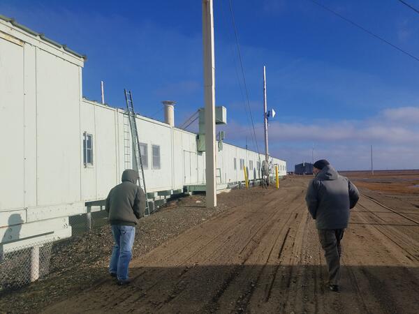
Walking perimeter of DEW Line site
Distant Early Warning (DEW) Line site contractor and Todd Atwood (USGS) walking the perimeter of the Alaska Oliktok Point Dew Line site and discussing polar bear safety.
Distant Early Warning (DEW) Line site contractor and Todd Atwood (USGS) walking the perimeter of the Alaska Oliktok Point Dew Line site and discussing polar bear safety.

Polar bear near the Katkotivk DEW Line site in Alaska
Polar bear near the Katkotivk DEW Line site in AlaskaPolar bear near the Kaktovik, Alaska, Distant Early Warning (DEW) Line site. In fall, polar bears gather at Kaktovik to feed on the remains of subsistence-harvested bowhead whales. Human-bear encounters at the DEW Line site are common.

USGS biologist conducting drone survey of walruses resting on shore
USGS biologist conducting drone survey of walruses resting on shoreUSGS uses survey drones, which are also termed “unoccupied aerial systems” or UAS, to survey walruses resting on shore. Use of these small survey drones enables collection of replicated surveys with minimal risk to walruses and humans. Being able to collect numerous replicate surveys enables precise estimates of walrus population abundance when these sur