Eric Reghr and Kristin Simac working on an anesthetized polar bear
Eric Reghr and Kristin Simac working on an anesthetized polar bearEric Reghr and Kristin Simac working on an anesthetized polar bear

Official websites use .gov
A .gov website belongs to an official government organization in the United States.
Secure .gov websites use HTTPS
A lock () or https:// means you’ve safely connected to the .gov website. Share sensitive information only on official, secure websites.
Browse images from a wide range of science topics covered by USGS. All items in this gallery are considered public domain unless otherwise noted.

Eric Reghr and Kristin Simac working on an anesthetized polar bear
Eric Reghr and Kristin Simac working on an anesthetized polar bear

Deformed beak Black-capped Chickadee next to peanut butter on a feeder
Deformed beak Black-capped Chickadee next to peanut butter on a feeder

A large flock of Bar-tailed Godwits flying near Egegik, Alaska
A large flock of Bar-tailed Godwits flying near Egegik, Alaska

Sockeye salmon spawning in the Grand Central River, on the Seward Peninsula near Salmon Lake, Alaska.
Sockeye salmon spawning in the Grand Central River, on the Seward Peninsula near Salmon Lake, Alaska.

Spawning sockeye salmon in the Grand Central River, near Nome, Alaska
Spawning sockeye salmon in the Grand Central River, near Nome, Alaska

A weir on the Snake River, near Nome, Alaska. This weir was used to count chum and coho salmon adults.
A weir on the Snake River, near Nome, Alaska. This weir was used to count chum and coho salmon adults.

Sockeye salmon in shallow waters of Salmon Lake which is at the headwaters of the Pilgrim River.
Sockeye salmon in shallow waters of Salmon Lake which is at the headwaters of the Pilgrim River.

Northern Fulmars on the water
Northern Fulmars on the water

Bring in the mid-water trawl on the R/V Alaskan Gyre
Bring in the mid-water trawl on the R/V Alaskan Gyre

Scenic view of the Fish River on Seward Peninsula, Alaska.
Scenic view of the Fish River on Seward Peninsula, Alaska.

Scenic view of the Fish River on Seward Peninsula, Alaska.
Scenic view of the Fish River on Seward Peninsula, Alaska.

Scenic view of the Nome River
Scenic view of the Nome River

Scenic view of the Nome River
Scenic view of the Nome River

Scenic view of the Nome River
Scenic view of the Nome River

Whiskered Auklet in the Aleutian Islands
Whiskered Auklet in the Aleutian Islands

Yukon River and rainbow near Eagle, Alaska
Yukon River and rainbow near Eagle, Alaska

Sheridan River sonar

George Durner collecting data on an anesthetized polar bear
George Durner collecting data on an anesthetized polar bear

Sheridan River scour hole
Sheridan River scour hole

The Advanced National Seismic System (ANSS) structural monitoring system in the 20- story Atwood Building is one of the most sophisticated systems in the country. Sensors are deployed on the parking and street levels, the electrical and mechanical levels, the roof level, and the 2nd, 7th, 8th, 13th, 14th, and 19th floors.
The Advanced National Seismic System (ANSS) structural monitoring system in the 20- story Atwood Building is one of the most sophisticated systems in the country. Sensors are deployed on the parking and street levels, the electrical and mechanical levels, the roof level, and the 2nd, 7th, 8th, 13th, 14th, and 19th floors.
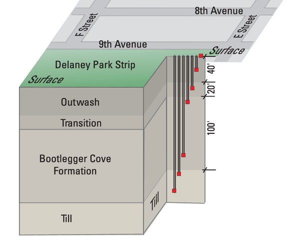
The Robert Atwood building sensors are complemented by the Delaney Park borehole array. This array of buried, three-component sensors in six boreholes ranging in depth from 15 to 200 feet (5–60 meters), with a seventh sensor at the surface.
The Robert Atwood building sensors are complemented by the Delaney Park borehole array. This array of buried, three-component sensors in six boreholes ranging in depth from 15 to 200 feet (5–60 meters), with a seventh sensor at the surface.