
View of central Alaska Range from the south.
Images
Browse images from a wide range of science topics covered by USGS. All items in this gallery are considered public domain unless otherwise noted.
Filter Total Items: 1612

Central Alaska Range
View of central Alaska Range from the south.

Denali Fault
At pass west of Delta River. Here there was roughly 5 m of offset. Note the push up in the background. There is permafrost at the bottom of the cracks.
At pass west of Delta River. Here there was roughly 5 m of offset. Note the push up in the background. There is permafrost at the bottom of the cracks.

Portage, Burns and Shakespeare glaciers in Southcentral Alaska
Portage, Burns and Shakespeare glaciers in Southcentral AlaskaPortage Glacier (right), Burns Glacier (center), Shakespeare Glacier (left) in Southcentral Alaska from the air.
Portage, Burns and Shakespeare glaciers in Southcentral Alaska
Portage, Burns and Shakespeare glaciers in Southcentral AlaskaPortage Glacier (right), Burns Glacier (center), Shakespeare Glacier (left) in Southcentral Alaska from the air.

Walruses resting on shore
More than 150 male walruses resting on shore at Cape Peirce in northern Bristol Bay
More than 150 male walruses resting on shore at Cape Peirce in northern Bristol Bay

A sunset seen from Kaktovik, Alaska
A sunset seen from Kaktovik, Alaska
A sunset seen from Kaktovik, Alaska

Beach seining on the Yukon River Delta
Jason Baker and Scott McLean pulling a beach seine in a side channel of the Yukon River
Jason Baker and Scott McLean pulling a beach seine in a side channel of the Yukon River

Alaska Mountain Range
Alaska mountain range.

Alaska Mountain Range
Alaska mountain range.

Alaska Scenic View
Scenic view of Alaskan lake and mountains.
Scenic view of Alaskan lake and mountains.

Polar bear mother and two cubs on the Beaufort Sea ice
Polar bear mother and two cubs on the Beaufort Sea icePolar bear mother and two cubs on the Beaufort Sea ice.
Polar bear mother and two cubs on the Beaufort Sea ice
Polar bear mother and two cubs on the Beaufort Sea icePolar bear mother and two cubs on the Beaufort Sea ice.

John Wild River, near Anaktuvuk
Looking upstream from mid channel of the John Wild River. Near Anaktuvuk, Alaska.
Looking upstream from mid channel of the John Wild River. Near Anaktuvuk, Alaska.


Aerial landscape of Teshekpuk Lake, Alaska
Aerial landscape of Teshekpuk Lake located in the National Petroleum Reserve-Alaska (NPR-A) on the Arctic Coastal Plain. Teshekpuk Lake and the surrounding area provide important habitat for migratory birds. This was one of many study site locations of waterbird-oriented ecosystem studies in the National Petroleum Reserve-Alaska from 1974-1992.
Aerial landscape of Teshekpuk Lake located in the National Petroleum Reserve-Alaska (NPR-A) on the Arctic Coastal Plain. Teshekpuk Lake and the surrounding area provide important habitat for migratory birds. This was one of many study site locations of waterbird-oriented ecosystem studies in the National Petroleum Reserve-Alaska from 1974-1992.

Overflight of East Long Lake, Alaska
Overflight photo of East Long Lake, Alaska. East Long Lake is in the Teshekpuk Lake Special Management Area of the National Petroleum Reserve-Alaska (NPR-A) on the Arctic Coastal Plain. This area provides important habitat for migratory birds.
Overflight photo of East Long Lake, Alaska. East Long Lake is in the Teshekpuk Lake Special Management Area of the National Petroleum Reserve-Alaska (NPR-A) on the Arctic Coastal Plain. This area provides important habitat for migratory birds.

Overflight 10 of East Long Lake, Alaska
Photo of overflight 10 of East Long Lake, Alaska. East Long Lake is in the Teshekpuk Lake Special Management Area of the National Petroleum Reserve-Alaska (NPR-A) on the Arctic Coastal Plain. This area provides important habitat for migratory birds.
Photo of overflight 10 of East Long Lake, Alaska. East Long Lake is in the Teshekpuk Lake Special Management Area of the National Petroleum Reserve-Alaska (NPR-A) on the Arctic Coastal Plain. This area provides important habitat for migratory birds.

Overflight 19 of East Long Lake, Alaska
Overflight 19 of East Long Lake, Alaska. East Long Lake is in the Teshekpuk Lake Special Management Area of the National Petroleum Reserve-Alaska (NPR-A) on the Arctic Coastal Plain. This area provides important habitat for migratory birds.
Overflight 19 of East Long Lake, Alaska. East Long Lake is in the Teshekpuk Lake Special Management Area of the National Petroleum Reserve-Alaska (NPR-A) on the Arctic Coastal Plain. This area provides important habitat for migratory birds.

Surface pools Teshekpuk Lake
Surface pools on the edge of West Long Lake in the Teshekpuk Lake Special Use Area of Alaska’s North Slope. These pools are formed by permafrost. During the summer months, snow and ice melt and the water remains pooled on the surface, resulting in thousands of pools and lakes that support wildlife.
Surface pools on the edge of West Long Lake in the Teshekpuk Lake Special Use Area of Alaska’s North Slope. These pools are formed by permafrost. During the summer months, snow and ice melt and the water remains pooled on the surface, resulting in thousands of pools and lakes that support wildlife.

Nesbett Courthouse
This simplified diagram of the Nesbett Courthouse shows how the building, completed in 1996, is meant to respond to ground movement that might occur below and beside it during an earthquake.
This simplified diagram of the Nesbett Courthouse shows how the building, completed in 1996, is meant to respond to ground movement that might occur below and beside it during an earthquake.
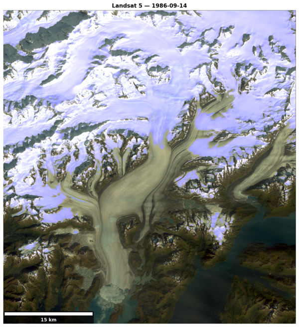
Columbia Glacier 1986
Landsat 5 image of Columbia Glacier, Alaska on Sept. 14, 1986.
Landsat 5 image of Columbia Glacier, Alaska on Sept. 14, 1986.

Tule white-fronted goose in the Kahiltna Valley, Alaska, in 1984
Tule white-fronted goose in the Kahiltna Valley, Alaska, in 1984Tule white-fronted goose in the Kahiltna Valley, Alaska, in 1984.
Tule white-fronted goose in the Kahiltna Valley, Alaska, in 1984
Tule white-fronted goose in the Kahiltna Valley, Alaska, in 1984Tule white-fronted goose in the Kahiltna Valley, Alaska, in 1984.

Landscape of Icy Cape, Alaska
Landscape photo of Icy Cape Alaska that is part of the National Petroleum Reserve-Alaska (NPR-A) on the Arctic Coastal Plain. This was one of many study site locations of waterbird-oriented ecosystem studies in the National Petroleum Reserve-Alaska from 1974-1992.
Landscape photo of Icy Cape Alaska that is part of the National Petroleum Reserve-Alaska (NPR-A) on the Arctic Coastal Plain. This was one of many study site locations of waterbird-oriented ecosystem studies in the National Petroleum Reserve-Alaska from 1974-1992.