
Semantics
Center of Excellence for Geospatial Information Science (CEGIS)
Graphs provide data computation that inform models of conditions and help us solve challenging problems about complex places and environments and processing.
Research about topographic feature semantic representations, characteristics, and related subjects for knowledge graph systems is shared among communities to address a range of applications.
Federated vocabulary
Controlled data attribute and property vocabularies such as their name or type take various formats.
By using namespace specifications, geographic data link to describe information units for knowledge organizing schemas such as glossaries or taxonomies.
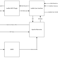
Information interoperability is based on close inferred meanings of other machine-readable data.
Language texts
Grammar rules for processing unstructured language texts can enhance statistical results by using an applied ontology.
Human readable text database strings are classified based on the dependency of meaning among words.
Dependency grammar representations are aligned with the roles of formal logic vocabularies that express machine-readable meaning in a graph.
Map semantics
Map applications assisted by artificial intelligence use visual and logic semantics for integrating attribute, property, and portrayal data.
Users can search along directed links, analyze results and their visual representation, specify further criteria for the interface to apply to query selections along the graph edges and filter to return relevant results.

2026 18th CEGIS Annual Research Meeting
2025 CEGIS Annual Research Meeting

Map semantics
Federated vocabulary
