
Knowledge Extraction
Center of Excellence for Geospatial Information Science (CEGIS)
Knowledge extraction is the process of finding information and features in data.
Knowledge extraction in CEGIS aims to investigate automated technologies for extracting features such as hydrography, terrain, and buildings. The long-term goals are to develop innovative approaches to solve geospatial tasks to leverage existing National Map data to maximize the utility of USGS data.
Deep learning (DL)
Deep learning (DL) is a subset of machine learning, with the difference that DL algorithms can automatically learn representations from data such as images, video, or text, without introducing human domain knowledge.
The word "deep" in deep learning represents the many layers of algorithms, or neural networks, that are used to recognize patterns in data.
Feature extraction
Feature extraction is the process of extracting features of interest from geospatial data using specialized approaches.
Extracted features are later used to generate informative datasets, which can be further utilized for classification or prediction.
Deep learning (DL) technology is now widely used for feature extraction from geospatial data.
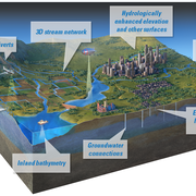
Terrain features
Terrain refers to the land surface and its many components.
Terrain data, such as information about elevation, slope, aspect (the orientation of the land), can play an integral part in many land change and management studies.
These data are particularly useful in the form of digital elevation models (DEMs).

2026 18th CEGIS Annual Research Meeting
2025 CEGIS Annual Research Meeting
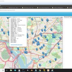
Query use cases
Terrain features

Feature extraction
Deep learning (DL)

Hydrographic feature extraction
