
Eyes on Earth: Data
USGS EROS hosts over 65 petabytes of Earth observation data, including the entire Landsat archive. The center is home to a Cray supercomputer called McKinley—the largest system in the Department of the Interior (DOI)—and has been deemed a data center consolidation location for the USGS and DOI. Learn about USGS EROS data processing efforts in these podcast episodes.
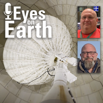
Episode 136 – The EROS Test Site

Landsat has been accurate and reliable for over 50 years because of the diligent calibration and validation work done by the team at EROS. One of the ways the team validates what they have so carefully calibrated is to take measurements on the ground while Landsat passes by overhead. For this Eyes on Earth podcast episode, we go out to the EROS test site during a Landsat pass to get a sense of what that work is like. Learn about the instruments used for this work and why it’s important to keeping Landsat as the gold standard for Earth observations.
Guests:
Jeff Irwin, USGS EROS
Travis Kropuenske, KBR, contractor for USGS EROS
Host: Tom Adamson (contractor for USGS EROS)
Release date: Thursday, June 12, 2025
Episode 135 – Exotic Annual Grasses and Sheep Grazing

Exotic annual grasses, or EAGs, are invasive species. They outcompete native grasses. They are extremely flammable. And they are expanding into higher elevations. Targeted sheep grazing is one way to combat these invasive grasses, manage fire risk, and help restore native sagebrush in western states.
The EROS team releases weekly EAG maps during the peak green-up in late April to early June, along with annual phenology maps to show the seasonal timing of the green-up. Dr. Kelly Hopping at Boise State University is using these maps to see whether targeted sheep grazing can help manage EAGs. The maps help researchers work with sheep producers to know when is the best time to move the sheep into those areas so their grazing can do the most good. The sheep then, as a part of the team solving the problem of invasive grasses, get to eat in the field when they might not otherwise have grazing available. Learn more in this episode of Eyes on Earth.
Guests:
Kelly Hopping, Boise State University
Matthew Rigge, USGS EROS
Devendra Dahal, KBR, contractor for USGS EROS
Trenton Benedict, KBR, contractor for USGS EROS
Host: Tom Adamson (contractor for USGS EROS)
Release date: Tuesday, May 27, 2025
Episode 134 – Data Accuracy: The Calibration and Validation of Landsat

Landsat is the longest-running, continuously operating record of Earth observations, and it’s the gold standard reference point that other civil and commercial satellite programs trust. If a researcher is studying multiple Landsat images of the same spot on Earth, and there is something in those images that suggests a change, that researcher needs to have the confidence that that change is a real change on the landscape and not because of something that changed or degraded in the sensor. Think of it this way. We are using a system to quantify changes on the Earth—we need to make sure the system itself is not changing.
Guest: Cody Anderson, USGS EROS
Host: Tom Adamson (contractor for USGS EROS)
Release date: Monday, May 5, 2025
Episode 133 – Vietnam War Bomb Craters

Declassified spy satellite imagery, distributed by the USGS EROS Center, is finding fascinating uses since being made available to the public starting in the 1990s. In this episode, we talk with Philipp Barthelme from the University of Edinburgh, who used imagery from the declassified HEXAGON and CORONA satellites to map bomb craters and herbicide spray lines from the Vietnam War. These features appear in the black and white photos quite clearly, so Barthelme worked out machine learning methods to automatically detect them. This method can help narrow down where to search for unexploded weapons and focus on the areas that are most contaminated.
Guest: Philipp Barthelme, University of Edinburgh, Edinburgh, United Kingdom
Host: Tom Adamson (contractor for USGS EROS)
Release date: Monday, April 14, 2025
Episode 132 – Moving Forward with AI at EROS

Eyes on Earth tackles artificial intelligence (AI) in a 2-part episode. AI is quickly becoming a necessary part of geospatial work at EROS, helping us efficiently do science to better manage our world. In Part 2, we discuss a potential application of AI—keeping Landsat satellites safe and healthy in orbit. Additionally, guests comment on how readily staff are adapting to using this rapidly evolving technology. They discuss the biggest benefits and challenges we face in using AI. Among the benefits are making EROS data products more accurate and reliable and getting them to the public in a more timely fashion.
Guests:
Pete Doucette, USGS EROS
Terry Sohl, USGS EROS
Neal Pastick, USGS EROS
Rylie Fleckenstein, contractor for USGS EROS
Host: Tom Adamson (contractor for USGS EROS)
Release date: Monday, March 24, 2025
Episode 131 – Using AI in Geospatial Work

Eyes on Earth tackles artificial intelligence (AI) in a 2-part episode. AI is quickly becoming a necessary part of geospatial work at EROS, helping us efficiently do science to better manage our world. In Part 1, EROS Director Pete Doucette discusses AI and its current and upcoming impact on our work at EROS. To help clarify AI terminology such as machine learning, deep learning, neural networks, transformers, and foundation models, we also talk to scientists who are using AI. And we learn about how AI enabled the National Land Cover Database (NLCD) to become an annual product.
Guests:
Pete Doucette, USGS EROS
Terry Sohl, USGS EROS
Neal Pastick, USGS EROS
Rylie Fleckenstein, contractor for USGS EROS
Host: Tom Adamson, contractor for USGS EROS
Release date: Monday, March 3, 2025

Episode 130 – NLCD Accuracy
Every pixel has a story. At least that’s how land remote sensing scientist Jo Horton sees it. The new Annual National Land Cover Database (NLCD) was just released in October 2024. NLCD is widely used for land cover and change research in the U.S. That’s why the Reference and Validation team provides accuracy metrics to users, and this work allows EROS to move land cover mapping science forward. Learn about what the Reference and Validation team does and what they are looking for when they closely examine thousands of Landsat sample pixels across the conterminous U.S. It sometimes involves some detective work as they figure out the stories of each pixel across time.
Guest: Jo Horton (contractor for USGS EROS)
Host: Tom Adamson (contractor for USGS EROS)
Release date: Monday, January 6, 2025
Episode 129 – What Happens During a Landsat Pass?
In this episode, we talk to ground station technicians to find out how Landsat satellite data gets from the spacecraft to EROS and then to the archive. We see what it’s like in EROS’s Landsat operations room and what the technicians do before, during, and after a Landsat pass. The task of making sure those bits of data make their way to the archive so it can be used for land change science occurs for them several times a day. As routine as it might be sometimes, they are a small but important part of a large mission that is documenting global land change.
Guests:
Aaron Hensley (contractor for USGS EROS)
Eric Gaspar (contractor for USGS EROS)
Host: Tom Adamson (contractor for USGS EROS)
Release date: Monday, December 9, 2024
Episode 128 – Fall Poster Session

In this episode, we mingle at the 2024 EROS Fall Poster Session. A poster session is a way for scientists to share their work with their colleagues in a public forum. About 30 posters were on display in the EROS atrium from EROS staff and several students from local universities.
Guests:
Natalie Liberati (South Dakota State University)
Brenden Elwer (South Dakota State University)
Madison DeJarlais (South Dakota State University)
Abhinav Chandel (University of South Dakota)
Jo Horton (KBR, contractor for USGS EROS)
Hua Shi (ASRC Federal Data Solutions, contractor for USGS EROS)
Lei Ji (ASRC Federal Data Solutions, contractor for USGS EROS)
Tim Smith (KBR, contractor for USGS EROS)
Brent Nelson (KBR, contractor for USGS EROS)
Brent Johnson (KBR, contractor for USGS EROS)
Host: Tom Adamson (contractor for USGS EROS)
Release date: Monday, November 25, 2024
Episode 126 – Annual NLCD

In this episode, we talk about the latest release of the National Land Cover Database (NLCD). More than just a map, NLCD is a stack of maps—a database. It has long been the foundational land cover source for scientists, resource managers, and decision-makers across the United States, and now the next generation of USGS land cover mapping is here. This new release includes land cover data of the United States for every year back to 1985, so it is now called Annual NLCD.
Guests:
Jesslyn Brown, USGS EROS
Jon Dewitz, USGS EROS
Host: Tom Adamson, contractor for USGS EROS
Release date: Monday, October 28, 2024
Episode 125 – The LANDFIRE Program at 20

In this episode, we talk about the Landscape Fire and Resource Management Planning Tools (LANDFIRE) project, which is commemorating its 20th year of providing geospatial data to support natural resource management and wildland fire planning. LANDFIRE brings a lot of data together, over 30 data products, into one place. The publicly available, consistent data maps disturbance to the landscape and vegetation condition, which can be useful to virtually any application that deals with what’s occurring on the landscape. LANDFIRE has now been doing this for 20 years, and we talk with some of the people who have been working on LANDFIRE that entire time.
Guests:
Jim Smith, The Nature Conservancy
Brian Tolk, KBR, contractor for USGS EROS
Brenda Lundberg, KBR, contractor for USGS EROS
Deborah Lissfelt, KBR, contractor for USGS EROS
Host: Tom Adamson, contractor for USGS EROS
Release date: Tuesday, October 15, 2024
Episode 123 – Bathymetry Mapping

This episode is the third in our series on using Landsat for coastal studies. We talk to physical geographer Jeff Danielson about bathymetry and how it is critical for coastal modeling. Bathymetry captures the shape of underwater topography, and satellite-derived bathymetry helps fill in areas where there are data gaps. Even though Landsat was designed to image land, it’s a big part of this work because of its systematic temporal coverage. Besides that, high-resolution data from sonar and lidar are too labor intensive to collect everywhere. Therefore, they use all these sources together to get a better picture of bathymetry, especially in remote areas. This modeling helps with studying changes to shorelines such as storm surge, sediment transport, and flood damage.
Guest: Jeff Danielson, USGS EROS
Host: Tom Adamson, contractor for USGS EROS
Release date: Thursday, September 12, 2024
Episode 122 – EROS Interns, 2024

In this episode, we talked with some of the interns who worked at EROS this summer. They shared their experiences learning about the cloud, AI, wildland fire research, terrestrial lidar scanning, and more. The common theme among them was recognizing the value of the EROS mission and noticing the passion their co-workers demonstrated in their work. They also shared advice for future interns at EROS.
Guests:
Carson Price, contractor for USGS EROS
Hunter Hagedorn, contractor for USGS EROS
Ryker Pedde, contractor for USGS EROS
Grace Parrott, USGS EROS
Hazel Mebius, contractor for USGS EROS
Katelyn Woolfrey, contractor for USGS EROS
Host: Tom Adamson, contractor for USGS EROS
Release Date: Wednesday, August 21, 2024
Episode 121 – Mapping the Australia Coastline

This episode is the second in a series about how Landsat is helping researchers study coastal changes. The first one was about mapping changes to beaches in California and using Landsat to create models to predict how the coastline may change in the future because of sea level rise and coastal erosion. For this episode, we talk with Robbi Bishop-Taylor, coastal Earth observation scientist at Geoscience Australia, about how he takes advantage of one of Landsat’s best features—time. Using Landsat data back to the 1980s and Open Data Cube to make the dataset openly available, researchers can see where shorelines are eroding and where they are growing around the entire coastline of Australia. Using sub-pixel mapping, they can make Landsat’s 30-meter pixels even more detailed while taking advantage of Landsat’s long archive.
Guest: Robbi Bishop-Taylor, Geoscience Australia
Host: Tom Adamson (contractor for USGS EROS)
Release date: Monday, July 29, 2024
Episode 120 – Mapping the California Coastline

In this episode, we begin a series on Landsat’s usefulness in coastal studies. First, we talk with Sean Vitousek, a USGS research oceanographer, about changes to beaches in California and how he is using Landsat and other data to create models that can predict how the coastline may change in the future because of sea level rise and coastal erosion. Landsat’s global reach stretches back decades—that, along with its free availability, can help in planning for the prevention and adaptation to future hazards along the coast. See how Landsat complements other data and ground truth studies, and how machine learning plays a part in this study as well.
Guest: Sean Vitousek, USGS Pacific Coastal and Marine Science Center
Host: Tom Adamson (contractor for USGS EROS)
Release date: Monday, July 15, 2024
Episode 118 – Preparing for Landsat Next, Part 2

In this episode, we talk with several people involved with the next Landsat mission, targeted for launch around 2030. While that may seem like a ways into the future, it takes a lot of work to prepare for such a big mission. In Part 2 of this two-part series on Landsat Next, we’ll hear about what needs to be done before launch to prepare the ground system, data processing and data calibration. Be sure to also listen to Part 1, where we talk about how different Landsat Next will be from previous Landsat missions, and what scientists are really looking forward to with this mission.
Guests: Brian Sauer, USGS Landsat Next Project Manager at EROS; Chris Engebretson, USGS Acting Ground System Manager for Landsat Next at EROS; Cody Anderson, USGS EROS Calibration and Validation Center of Excellence Project Manager
Host: Tom Adamson (contractor for USGS EROS)
Release date: Monday, May 6, 2024
Episode 117 – Preparing for Landsat Next, Part 1

In this episode, we talk with several people involved with the next Landsat mission. In Part 1, we’ll hear about how different Landsat Next will be from previous Landsat missions and how its additional spectral bands, higher resolution, and 6-day revisit will benefit science and society. Addressing the needs of the Landsat user community was a high priority in developing the mission, so we talk about what scientists are really looking forward to with Landsat Next. The Part 2 episode shares details about technical preparations, such as the ground system and data processing and validation.
Guests: Tim Newman, USGS Program Coordinator for National Land Imaging; Zhuoting Wu, USGS Earth Observation Applications Coordinator for National Land Imaging; Chris Crawford, USGS Research Physical Scientist
Host: Tom Adamson (contractor for USGS EROS)
Release date: Monday, April 22, 2024
Episode 111 – Mendenhall Fellow’s Drought Forecasting

In this episode, we spoke to Mikael Hiestand, a Mendenhall Postdoctoral Fellow. Using algorithms developed at EROS, Mikael is working on near-term drought forecasting. With synthetic Landsat data, he found that predicting evapotranspiration could be used as a means of drought prediction and monitoring. The Mendenhall Fellowship allows people who have just completed their PhD an opportunity to work on research with USGS scientists and prepare for their career.
Guest: Mikeal Hiestand, USGS Mendenhall Postdoctoral Fellow and Research Physical Scientist
Host: Tom Adamson (contractor for USGS EROS)
Release date: Monday, January 22, 2024
Episode 108 – Landsat 8’s 100th Drag Make-Up Maneuver

The Landsat Program is considered the gold standard for satellite Earth-observation imagery. To keep it that way, the USGS EROS Flight Operations Team continually monitors the flight paths of the Landsat satellites to make sure they stay at a consistent 705-kilometer altitude. That means frequently speeding it up to counter the effects of atmospheric drag. But that’s not all. The team accounts for solar activity, space junk, and other factors to keep the satellites safe. Landsat 8’s 100th Drag Make-Up maneuver in October 2023 gives us the opportunity, in this episode, to talk about these and the other maneuvers the flight team executes and how they work.
Guest: Larry Tornabene, Flight Systems Manager for Landsat 8
Host: Tom Adamson (contractor for USGS EROS)
Producer: Tom Adamson (contractor for USGS EROS)
Release date: Monday, November 20, 2023
Episode 95 – EROS 50th: Landsat Science Team

The members of the five-year Landsat Science Teams, led jointly by the USGS and NASA with a strong tie to EROS, have brought a wide breadth of expertise, backgrounds and geographic locations to the table. In this episode, we learn how members have explored strategies for the effective use of archived Landsat data and integration of future data, and how they have helped identify Landsat user needs for upcoming satellite sensors, including those on the future Landsat Next.
Guests: Curtis Woodcock, Boston University and 4 terms on Landsat Science Team; Mike Wulder, Canadian Forest Service and 3 terms on Landsat Science Team; David Roy, Michigan State University professor and 2 terms on Landsat Science Team
Host: Jane Lawson (contractor for USGS EROS)
Release date: Wednesday, June 7, 2023
Episode 93 – EROS 50th: Film Scanning

Working with film has always been part of EROS’ 50-year history. How did EROS end up with an extensive film archive, and how are we making that data available to users? In this episode, we talk about the custom scanners built in-house from discarded parts to digitally capture historical aerial photos and declassified spy satellite images. These Phoenix systems have scanned millions of images and still have a lot of work to do.
Guests: Tim Smith and Mike Austad (contractors for USGS EROS)
Host: Tom Adamson (contractor for USGS EROS)
Release date: Monday, April 3, 2023
Episode 79 – Landsat Global Archive Consolidation

The Landsat archive at EROS contains an unparalleled 50 years of Earth observation data. But with earlier technologies, some Landsat scenes were collected and stored only by international ground receiving stations rather than in the central archive at EROS. More than 10 years ago, to help make that far-flung data available to scientists interested in land change over time, the Landsat Global Archive Consolidation (LGAC) project began having the reels and tapes sent to EROS to digitize that information. In this episode of Eyes on Earth, we learn how that project has deepened the archive dramatically.
Guests: Todd Taylor, EROS contract task lead for Sustaining Land Imaging partnership support, and contractor Jayson Holter, EROS task manager for the Landsat Missions Operations Project, Ground Operations
Host: Tom Adamson
Release date: August 29, 2022
Episode 74 – A Satellite Cross Calibration Mission

When the first Landsat satellite launched 50 years ago, it was the only game in town in terms of civilian land remote sensing. In the years that followed, a host of satellites have launched to serve similar purposes. But that data doesn't always play well together. Subtle differences between the measurements taken by satellites make it difficult to do apples to apples comparisons of land change. On this episode of Eyes on Earth, we hear from the USGS partners working with partners in Australia to launch a satellite cross calibration mission that will offer a common reference post and serve as a sort of “translation tool” to help remote sensing scientists to use datasets together to study changes to the Earth’s surface.
Guests: Greg Stensaas, USGS EROS, Grant Mah, USGS EROS, Jon Christopherson, USGS EROS contractor
Host: John Hult
Release date: May 31, 2022
Episode 58 - Satellites and Cloud Computing

Satellite imagery is everywhere. We see it on TV news and weather coverage, in our Twitter and Facebook feeds, and on our phones’ mapping apps. The data behind that imagery is nothing like a screenshot, though. It’s comprised of tiny packets of data, broken down from huge files and digitally manipulated to resemble the surface of the Earth, a swirling storm system or a map of urban growth. Cloud computing resources can make it easier to work with huge datasets that cover long periods of time, which is why many remote sensing scientists are using it for their analyses. On this episode of Eyes on Earth, we hear from a scientist who used the cloud for a 150-year water use modeling project, and from a data scientist working to help train others to use cloud resources.
Guests: Stefanie Kagone, contract remote sensing scientist, USGS EROS Center; Aaron Friesz, contract science coordination lead for NASA Land Processes Distributed Active Archive Center (LP DAAC).
Host: John Hult
Release date: Sept. 7, 2021
Episode 54 – National Land Cover Database 2019

The National Land Cover Database, or NLCD, was the first and remains the most well-known set of satellite-based land cover mapping products released by EROS. It sorts the each 30-by-30-meter plot of land in the United States into a land cover class, such as cropland, pasture, high-intensity developed, deciduous forest, and the like. It also includes information on impervious urban surfaces, forest canopy cover and more. For this episode of Eyes on Earth, we hear about the latest release, NLCD 2019, the importance of land cover, and how mapping teams at EROS work together to produce accurate, reliable information.
Guest: Jon Dewitz, USGS National Land Cover Database manager
Host: John Hult
Release date: July 12, 2021
Episode 51 – LANDFIRE 2019 Limited

The fire science community is always on the lookout for the freshest satellite-derived fire disturbance maps. Aiming to meet those needs, the multi-agency partnership known as LANDFIRE has just released an update that adds three new years of disturbances across the U.S. to its 20-plus layers of GIS data. LANDFIRE 2019 Limited is a step toward annual updates for the program, which is relied upon nationwide to guide land management and fire planning. On this episode, two LANDFIRE leaders talk about why they’re working to speed up new releases.
Guests: Henry Bastian, LANDFIRE Business Lead, Department of Interior, Frank Fay, LANDFIRE Business Lead, USDA Forest Service
Host: John Hult
Release date: June 1, 2021
Episode 45 – Harmonized Landsat Sentinel Data

Landsat satellites have monitored the Earth’s surface for nearly 50 years, providing critical information for countless areas of study and real world applications. But with observations only collected every 8-16 days, there are limits to what can be tracked. On today’s episode of Eyes on Earth, we hear about a soon-to-be-released data product that merges Landsat with data from the European Space Agency’s Sentinel-2 satellites, which will offer more opportunities to monitor rapid change. The harmonized Landsat-Sentinel data will be available through the Land Processes Distributed Active Archive Center (LP DAAC), located at the USGS Earth Resources Observation and Science (EROS) Center.
Guest: Dr. Jeffrey Masek, NASA Landsat Project Scientist, Brian Freitag, NASA Research Physical Scientist
Host: John Hult
Release date: March 8, 2021
Episode 40 – Landsat Collection 2

Landsat data is more useful today than at any other point in its nearly 50-year history. The USGS Collections strategy is a major reason why. Landsat Collections align and correct satellite acquisitions from 1972 through the present to make the data easier to work with through time. The USGS has now released Collection 2, an upgrade that improves geometric accuracy, improves interoperability with other satellite data sources, eases access to Landsat Level-2 science products, and makes Landsat data available in a cloud-friendly format for the first time. On this episode, we hear about what life was like for Landsat users before Collections, what it’s like now, and how Collection 2 will open doors for more innovative, expansive research.
Guest: Dr. Chris Barnes, USGS contractor for the Landsat International Cooperator Network; Dr. Chris Barber, USGS research physical scientist with Land Change Monitoring, Assessment, and Projection (LCMAP)
Host: John Hult
Release date: December 14, 2020
Episode 38 – Time Series Analysis with Landsat

In the past, remote sensing scientists looked for change on the Earth’s surface primarily by comparing one Landsat image to another. Today, open access to Landsat data, high-performance and cloud computing capabilities and sophisticated algorithms can be used to scan the entirety of the archive for change, enabling researchers to learn more about how the landscape shifts over time. On this episode of Eyes on Earth, Landsat Science Team member Dr. Curtis Woodcock shares his thoughts on time series analysis, the future of remote sensing and his hopes for the Landsat program.
Guest: Dr. Curtis Woodcock, Boston University
Host: Steve Young
Release date: November 16, 2020
Episode 34 – Open Training Data
Today, the world is awash in remotely sensed data. Satellites launched by countries and commercial companies circle the planet collecting data every day. Accessing data from multiple agencies and platforms and turning it into useful analysis can be a daunting and complex endeavor, however. On today’s episode of Eyes on Earth, we hear from the founder of the non-profit Radiant Earth Foundation, which works to connect the global development community with the remote sensing data and machine learning tools it needs to tackle social, economic and environmental issues. One major initiative involves opening access to satellite-based training data, such as crop classifications, land cover and the like, and connecting users to cloud computing resources that help users search for trends and changes across space and time.
Guest: Anne Hale Miglarese, Founding CEO of Radiant Earth Foundation
Host: Steve Young
Release date: September 21, 2020
Episode 32 – Lunar Calibration

Calibration teams at the USGS EROS Center use a variety of methods to make sure the data collected by Landsat satellites are an accurate representation of the Earth’s surface. They’re constantly comparing new imagery to old, tweaking algorithms to correct issues that might emerge, and using unchanging Earth surface sites and on-the-ground readings to check for consistency. Since the launch of Landsat 8, they’ve come to rely on another unchanging landscape to check for quality: the lunar surface. In this episode of Eyes on Earth, we hear how it’s done.
Guest: Cody Anderson, USGS EROS Cal-Val Center of Excellence Project Manager
Host: Tom Adamson
Release date: August 24, 2020
Episode 19 – 100 Million Landsat Downloads

For decades, each Landsat image had a price tag – a hefty one at times ranging from 400 dollars to as much as 4,000 dollars. That all changed in 2008 with the enactment of an open data policy that made the entire Landsat archive available for download at no cost to the user. In this episode of Eyes on Earth, we talk with one of the architects of that policy, as well as an EROS data manager who saw the post-2008 spike in Landsat data use in real time. The 100 millionth Landsat scene was recently downloaded from the EROS archive, marking a major milestone for a policy shift that opened the door to previously impossible wide-scale research projects and generated billions of dollars in returns worldwide.
Guests: Barb Ryan, former Secretariat-Director for the Group on Earth Observations (GEO) and former Associate Director of Geography for USGS; Kristi Kline, Project Manager for the Landsat Archive.
Host: Steve Young
Release date: March 13, 2020
Episode 16 – Predictive Modeling

Land cover and land use across the United States are the culmination of a complex web of interwoven factors: Climate, landscape types, and economic factors among them. Remotely-sensed data from satellites like Landsat and a variety of other sources are useful for documenting and monitoring land cover and land use. When used alongside other data sources, however, remote sensing data can offer a glimpse at future land use under a range of scenarios.
Guests: Terry Sohl, Research Physical Scientist, EROS
Host: Steve Young
Release date: Feb. 10, 2020
Episode 5 - Declassified Data at EROS
There’s a lot more than Landsat in the EROS Archive. In this episode of Eyes on Earth, we hear from a professor who’s mined satellite data collected during once-classified military missions to peer into the history of land use in Eastern Europe during the height of the Cold War.
Guest: Volker Radeloff, professor in the Department of Forest and Wildlife Ecology at the University of Wisconsin in Madison
Host: Steve Young
Release date: Oct. 7, 2019