
Dallas-Fort Worth, Texas, slid into Landsat 1's view on July 25, 1972. In this false-color image, shades of red indicate vegetated land and grays and whites are urban or rocky surfaces. The composite image is shown using the near-infrared, red and green bands (bands 7, 5, 4) at a 60 meter resolution.
Images
Peruse our selection of remote sensing and Earth science imagery below.
Filter Total Items: 869

Landsat 1 First Light Image of Texas
Dallas-Fort Worth, Texas, slid into Landsat 1's view on July 25, 1972. In this false-color image, shades of red indicate vegetated land and grays and whites are urban or rocky surfaces. The composite image is shown using the near-infrared, red and green bands (bands 7, 5, 4) at a 60 meter resolution.

Landsat 1 (ERTS) launch pad
A Delta rocket containing Landsat 1, then called Earth Resources Technology Satellite, or ERTS, sits on the launch pad at Vandenberg Air Force Base in California in July 1972. NASA photo
A Delta rocket containing Landsat 1, then called Earth Resources Technology Satellite, or ERTS, sits on the launch pad at Vandenberg Air Force Base in California in July 1972. NASA photo

Declassified satellite imagery of the Forbidden City in Beijing, China
Declassified satellite imagery of the Forbidden City in Beijing, ChinaA view of the Forbidden City in Beijing, China, from declassified satellite imagery stored in the archive at the USGS Earth Resources Observation and Science (EROS) Center.

William T. Pecora
Pecora, a geologist, served as director of the U.S. Geological Survey from 1965 to 1971 and as under secretary of the Department of the Interior from 1971 until his death in 1972. Pecora advocated for the potential of remote sensing for Earth observation and led the development of the Earth Resources Observation Systems program in 1966.
Pecora, a geologist, served as director of the U.S. Geological Survey from 1965 to 1971 and as under secretary of the Department of the Interior from 1971 until his death in 1972. Pecora advocated for the potential of remote sensing for Earth observation and led the development of the Earth Resources Observation Systems program in 1966.

Yucca Flat - 1965
An GAMBIT satellite image of Yucca Flat in Nevada, circa 1965.
An GAMBIT satellite image of Yucca Flat in Nevada, circa 1965.
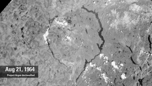
Lake Manicouagan, 1964 (Project Argon declassified imagery)
Lake Manicouagan, 1964 (Project Argon declassified imagery)A declassified 1964 satellite image from the CIA’s Project Argon shows two crescent-shaped lakes originally outlining the ancient impact zone of modern day Lake Manicouagan.
Lake Manicouagan, 1964 (Project Argon declassified imagery)
Lake Manicouagan, 1964 (Project Argon declassified imagery)A declassified 1964 satellite image from the CIA’s Project Argon shows two crescent-shaped lakes originally outlining the ancient impact zone of modern day Lake Manicouagan.

Yucca Flat - 1952
An aerial image of Yucca Flat in Nevada, circa 1952
An aerial image of Yucca Flat in Nevada, circa 1952

Measuring Forest Structure with LiDAR
A LiDAR (Light Detection and Ranging) instrument measures the 3-D structure of a ponderosa pine forest stand in Coconino National Forest near Flagstaff, Arizona, on July 13, 2009.
A LiDAR (Light Detection and Ranging) instrument measures the 3-D structure of a ponderosa pine forest stand in Coconino National Forest near Flagstaff, Arizona, on July 13, 2009.