
A sagebrush steppe landscape in northern Nevada, photographed during field work near Owyhee.
Images
If you are unable to access or download a product, email fresc_outreach@usgs.gov a request, including the full citation, or call (541) 750-1030.
Filter Total Items: 421

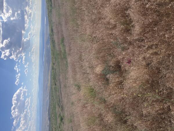
Sagebrush steppe at dusk
A sagebrush steppe landscape in northern Nevada, photographed during field work near Owyhee.

Herbicide treated plot in northern Nevada
A plot that was sprayed with herbicides to control invasion of exotic annual grasses after the Martin Fire in northern Nevada. The white line defines the boundaries of the plot.
A plot that was sprayed with herbicides to control invasion of exotic annual grasses after the Martin Fire in northern Nevada. The white line defines the boundaries of the plot.

Surveying for northwestern pond turtles
Scientists using binoculars and radio telemetry to survey for northwestern pond turtles at Hills Creek Reservoir in Oregon. USGS is collaborating with the U.S. Army Corps of Engineers to study turtle movements in reservoirs in response to fluctuating water levels.
Scientists using binoculars and radio telemetry to survey for northwestern pond turtles at Hills Creek Reservoir in Oregon. USGS is collaborating with the U.S. Army Corps of Engineers to study turtle movements in reservoirs in response to fluctuating water levels.

Analyzing post-fire restoration field data
A FIREss team scientist analyzing field data at the Snake River Field Station in Boise, Idaho.
A FIREss team scientist analyzing field data at the Snake River Field Station in Boise, Idaho.

Map of herbicide treatment experiment in Idaho
A map of an area of the Minidoka National Wildlife Refuge that was burned by wildfire. Researchers conducted experiments testing the longevity of herbicides for controlling exotic annual grasses. The fire perimeter is displayed with a red outline. Stripes of tan were sprayed with indaziflam. Stripes of purple were treated with indaziflam and imazapic.
A map of an area of the Minidoka National Wildlife Refuge that was burned by wildfire. Researchers conducted experiments testing the longevity of herbicides for controlling exotic annual grasses. The fire perimeter is displayed with a red outline. Stripes of tan were sprayed with indaziflam. Stripes of purple were treated with indaziflam and imazapic.

Sagebrush seedling planted at the site of the Soda fire
Sagebrush seedling planted at the site of the Soda fireA sagebrush seedling that was grown in a nursery and then planted at the Idaho/Oregon Soda wildfire treatment area
Sagebrush seedling planted at the site of the Soda fire
Sagebrush seedling planted at the site of the Soda fireA sagebrush seedling that was grown in a nursery and then planted at the Idaho/Oregon Soda wildfire treatment area

Nevada sagebrush steppe landscape at sunset
A field of sagebrush in northern Nevada, photographed at sunset after a day of field work.
A field of sagebrush in northern Nevada, photographed at sunset after a day of field work.

Monitoring vegetation recovery at the site of the Martin Fire
Monitoring vegetation recovery at the site of the Martin FireA field technician photographing a vegetation monitoring plot at the site of the Martin Fire in northern Nevada.
Monitoring vegetation recovery at the site of the Martin Fire
Monitoring vegetation recovery at the site of the Martin FireA field technician photographing a vegetation monitoring plot at the site of the Martin Fire in northern Nevada.

Vegetation monitoring in Idaho
Scientists in the field monitoring the effects of experimental herbicide treatments for controlling exotic annual grasses in the Boise River Wildlife Management Area.
Scientists in the field monitoring the effects of experimental herbicide treatments for controlling exotic annual grasses in the Boise River Wildlife Management Area.

Sagebrush plant in Boise, Idaho
A sagebrush plant photographed at a park in Boise, Idaho. Sagebrush landscapes cover a vast part of the western U.S. but are threatened by invasive grasses and a cycle of more frequent and more intense wildfires.
A sagebrush plant photographed at a park in Boise, Idaho. Sagebrush landscapes cover a vast part of the western U.S. but are threatened by invasive grasses and a cycle of more frequent and more intense wildfires.

Tracking northwestern pond turtles at Fall Creek Reservoir
Tracking northwestern pond turtles at Fall Creek ReservoirUSGS scientist Nick Esser using radio telemetry to track northwestern pond turtles at Fall Creek Reservoir in Oregon. USGS researchers partner with the U.S. Army Corps of Engineers to study movement of turtles in response to fluctuating water levels.

Drill seeded plot at the site of the Martin Fire
An experimental plot that was drill seeded with native grasses after the Martin Fire in northern Nevada. Drill seeding is a method in which a drill buries seeds into the soil at a targeted depth that is ideal for that plant species. A tractor typically pulls the drill along to bury the seeds in rows.
An experimental plot that was drill seeded with native grasses after the Martin Fire in northern Nevada. Drill seeding is a method in which a drill buries seeds into the soil at a targeted depth that is ideal for that plant species. A tractor typically pulls the drill along to bury the seeds in rows.
Burned and invaded landscape in Wyoming
This landscape south of Rock Springs, Wyoming was burned and subsequently invaded by cheatgrass. Cheatgrass has a short growing season and leaves behind mats of dry, dead material that serves as wildfire fuel--contributing to a cycle of more frequent and larger wildfires and more plant invasions.
This landscape south of Rock Springs, Wyoming was burned and subsequently invaded by cheatgrass. Cheatgrass has a short growing season and leaves behind mats of dry, dead material that serves as wildfire fuel--contributing to a cycle of more frequent and larger wildfires and more plant invasions.

Cheatgrass and sagebrush shrubs in Wyoming
This site south of Rock Springs in Wyoming was not burned but cheatgrass has invaded the space between sagebrush shrubs.
This site south of Rock Springs in Wyoming was not burned but cheatgrass has invaded the space between sagebrush shrubs.
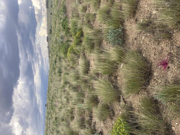
Natural recovery of native vegetation post-wildfire
Natural recovery of native vegetation post-wildfireThis site was burned but not invaded by exotic annual grasses. Many perennial bunchgrasses were present before the fire and were able to recover quickly afterwards.
Natural recovery of native vegetation post-wildfire
Natural recovery of native vegetation post-wildfireThis site was burned but not invaded by exotic annual grasses. Many perennial bunchgrasses were present before the fire and were able to recover quickly afterwards.

Sagebrush patches invaded by cheatgrass
Cheatgrass has invaded the space between sagebrush shrubs on this landscape south of Rock Springs in Wyoming.
Cheatgrass has invaded the space between sagebrush shrubs on this landscape south of Rock Springs in Wyoming.

Measuring plant cover at the site of the Martin Fire
Measuring plant cover at the site of the Martin FireA field technician measuring plant cover at a monitoring plot at the site of the Martin Fire in northern Nevada. The plot is marked with a pin flag.
Measuring plant cover at the site of the Martin Fire
Measuring plant cover at the site of the Martin FireA field technician measuring plant cover at a monitoring plot at the site of the Martin Fire in northern Nevada. The plot is marked with a pin flag.

Burned landscape invaded by cheatgrass
This landscape in Rabbit Valley in Colorado was burned and then invaded by the exotic annual grass cheatgrass. A formerly diverse plant community was replaced by a sea of highly flammable grass.
This landscape in Rabbit Valley in Colorado was burned and then invaded by the exotic annual grass cheatgrass. A formerly diverse plant community was replaced by a sea of highly flammable grass.

Aerial seeded plot at the site of the Martin Fire
A plot that was aerially seeded with native plants after the Martin Fire in northern Nevada. Aerial seeding is a method in which a helicopter or plane drops seeds across large regions.
A plot that was aerially seeded with native plants after the Martin Fire in northern Nevada. Aerial seeding is a method in which a helicopter or plane drops seeds across large regions.

Vegetation and soil data collection at Castle Rocks, Idaho
Vegetation and soil data collection at Castle Rocks, IdahoA Project ROAM (Rapid and Other Methods for Assessment and Monitoring) crew collecting vegetation data at a complex plot with over 40 unique species.
Vegetation and soil data collection at Castle Rocks, Idaho
Vegetation and soil data collection at Castle Rocks, IdahoA Project ROAM (Rapid and Other Methods for Assessment and Monitoring) crew collecting vegetation data at a complex plot with over 40 unique species.

Swainson's hawk perched on a power pole
A Swainson's hawk perched on a power pole in the Morley Nelson Snake River Birds of Prey National Conservation Area in southern Idaho.
A Swainson's hawk perched on a power pole in the Morley Nelson Snake River Birds of Prey National Conservation Area in southern Idaho.