
Cheatgrass growing in a high-density plot covered in black gravel. Black gravel warms the soil surface. The colors on the toothpicks indicate the genotype of cheatgrass planted. Researchers selected a variety of genotypes—plants of the same species that are genetically distinct—that are found locally.
Images
If you are unable to access or download a product, email fresc_outreach@usgs.gov a request, including the full citation, or call (541) 750-1030.
Filter Total Items: 421

Cheatgrass planted in a black gravel plot
Cheatgrass growing in a high-density plot covered in black gravel. Black gravel warms the soil surface. The colors on the toothpicks indicate the genotype of cheatgrass planted. Researchers selected a variety of genotypes—plants of the same species that are genetically distinct—that are found locally.

X-ray of a shot bald eagle
An x-ray image taken during an examination to determine the cause of death of a bald eagle found along power lines near Jordan Valley, Oregon. The eagle was determined to have died from gunshot, shotgun pellets are visible as bright white speckles.
An x-ray image taken during an examination to determine the cause of death of a bald eagle found along power lines near Jordan Valley, Oregon. The eagle was determined to have died from gunshot, shotgun pellets are visible as bright white speckles.

Photograph and x-ray of a bald eagle found dead along a power line in Oregon
Photograph and x-ray of a bald eagle found dead along a power line in OregonA photograph and x-ray taken during an examination of a bald eagle found dead near a power line near Jordan Valley, Oregon. Because of the extensive singeing of the feathers on the wings and body, the bird was initially assumed to have died from electrocution.

Environmental DNA Sampler
Smith-Root eDNA sampler collecting and filtering water from a tributary of the Okanogan River. Researchers are looking for traces of environmental DNA from spring-Chinook salmon that were reintroduced in the river.
Smith-Root eDNA sampler collecting and filtering water from a tributary of the Okanogan River. Researchers are looking for traces of environmental DNA from spring-Chinook salmon that were reintroduced in the river.

Bald eagle found dead near power lines
A bald eagle found dead near power lines near Jordan Valley, Oregon, is examined to determine its cause of death. X-rays revealed the eagle died from gunshot.
A bald eagle found dead near power lines near Jordan Valley, Oregon, is examined to determine its cause of death. X-rays revealed the eagle died from gunshot.

How to Interact with the Wildland Fire Trends Tool Perimeter Dashboard
How to Interact with the Wildland Fire Trends Tool Perimeter DashboardThis dashboard displays summary data for portions of wildland fire perimeters (polygons) that occur within the selected filters. To display fire trends, it is recommended to filter out the smallest fires - those less than 1,000 acres. For large queries, please allow the tool a minute to process the request.

How to Interact with the Burned Area Dashboard of the Wildland Fire Trends Tool
How to Interact with the Burned Area Dashboard of the Wildland Fire Trends ToolThis dashboard displays summary wildfire data for those areas of raster wildfires that occur within the selected filters. Change the dashboard view with the filters across the top. Hover over data in each visualization for more information. Rows resize to fit the selected data. You may need to select more narrow filter options to obtain the best visual results.

Bat call from silver-haired bat
A screen shot of a silver-haired bat (Lasionycteris noctivagans) call captured by an acoustic detector, a specialized microphone that can capture species-specific high frequency sounds.
A screen shot of a silver-haired bat (Lasionycteris noctivagans) call captured by an acoustic detector, a specialized microphone that can capture species-specific high frequency sounds.

Bat call from a silver-haired bat
A screen shot of a Yuma myotis bat (Myotis yumanensis) call captured by an acoustic detector, a specialized microphone that can capture species-specific high frequency sounds.
A screen shot of a Yuma myotis bat (Myotis yumanensis) call captured by an acoustic detector, a specialized microphone that can capture species-specific high frequency sounds.

Surveying for plants in a cheatgrass invaded landscape
Surveying for plants in a cheatgrass invaded landscapeResearchers identified plants along a transect at a site invaded by cheatgrass at Kuna Butte near Caldwell, Idaho.
Surveying for plants in a cheatgrass invaded landscape
Surveying for plants in a cheatgrass invaded landscapeResearchers identified plants along a transect at a site invaded by cheatgrass at Kuna Butte near Caldwell, Idaho.

Damaged Culvert in Central Oregon
A damaged stream-road crossing, or culvert, near Redmond, Oregon. Damaged culverts can block streamflow and fish passage.
A damaged stream-road crossing, or culvert, near Redmond, Oregon. Damaged culverts can block streamflow and fish passage.

Surveying for salamanders in Oregon
USGS scientist Jennifer Rowe ready to scramble up a stream to survey for Cascade torrent salamanders. A small aquarium net is used to gently disturb sediment to flush out larvae and adults.
USGS scientist Jennifer Rowe ready to scramble up a stream to survey for Cascade torrent salamanders. A small aquarium net is used to gently disturb sediment to flush out larvae and adults.
Road through a burned landscape in Idaho
The area to the right of this road outside of Marsing, Idaho burned in 2002, 2015, and 2022.
The area to the right of this road outside of Marsing, Idaho burned in 2002, 2015, and 2022.

Lone goose at sunrise at Summer Lake Wildlife Area
Lone goose at sunrise at Summer Lake Wildlife AreaLooking east on Bullgate Pond at sunrise with lone tule white-fronted goose (Anser albifrons elgasi) in upper right, Summer Lake Wildlife Area, near Summer Lake, Oregon.
By
Ecosystems Mission Area, Water Resources Mission Area, Species Management Research Program, Water Availability and Use Science Program, Forest and Rangeland Ecosystem Science Center, Fort Collins Science Center, Nevada Water Science Center, Oregon Water Science Center, Utah Water Science Center, Western Ecological Research Center (WERC), Saline Lake Ecosystems Integrated Water Availability Assessment
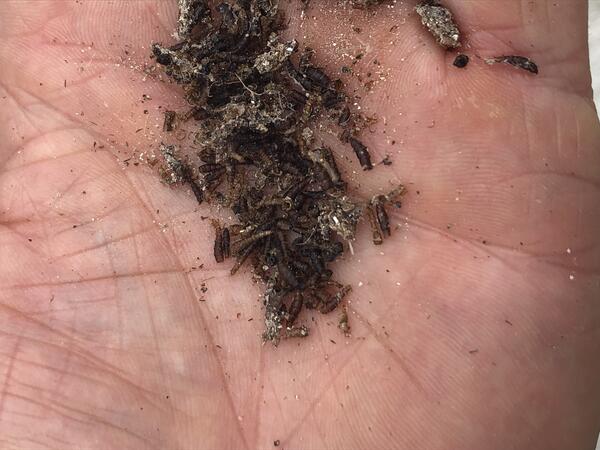
Brine fly pile
These brine flies are an important fuel source for migratory birds, giving them energy for long flights.
By
Ecosystems Mission Area, Water Resources Mission Area, Species Management Research Program, Forest and Rangeland Ecosystem Science Center, Nevada Water Science Center, Oregon Water Science Center, Utah Water Science Center, Western Ecological Research Center (WERC), Saline Lake Ecosystems Integrated Water Availability Assessment
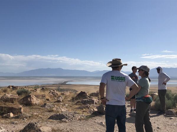
Scientist looking out onto the GSL from Antelope Island
Scientist looking out onto the GSL from Antelope IslandThese scientists are working on The Great Salt Lake to determine the amount of water and qualities of it. This will help them in developing better management techniques that will work to support the migratory birds that frequent the area.
By
Ecosystems Mission Area, Water Resources Mission Area, Species Management Research Program, Forest and Rangeland Ecosystem Science Center, Fort Collins Science Center, Nevada Water Science Center, Oregon Water Science Center, Utah Water Science Center, Western Ecological Research Center (WERC), Saline Lake Ecosystems Integrated Water Availability Assessment

Wind turbines in Aktau, Kazakhstan
A wind farm in Aktau, Kazakhstan photographed during a visit from USGS scientist Todd Katzner.
A wind farm in Aktau, Kazakhstan photographed during a visit from USGS scientist Todd Katzner.

Wind turbines in Kazakhstan
A wind farm in Aktau, Kazakhstan photographed during USGS scientist Todd Katzner's visit in 2022.
A wind farm in Aktau, Kazakhstan photographed during USGS scientist Todd Katzner's visit in 2022.

Elwha River, Olympic National Park
The former Mills reservoir restoration area on the Elwha River in Olympic National Park, WA. This photo taken from the Glines overlook shows the revegetation that has occurred at the former reservoir post-dam removal.
The former Mills reservoir restoration area on the Elwha River in Olympic National Park, WA. This photo taken from the Glines overlook shows the revegetation that has occurred at the former reservoir post-dam removal.
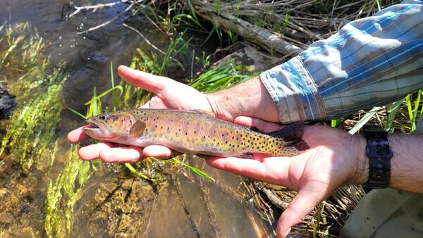
Cutthroat trout being held
Cutthroat trout being held up by a male biologist with a watch and blue flannel shirt on. Below the fish is a stream with rocks, plants, and mud.
Cutthroat trout being held up by a male biologist with a watch and blue flannel shirt on. Below the fish is a stream with rocks, plants, and mud.

Elk captured by trail cam near the Elwha River, WA
Elk captured by trail cam near the Elwha River, WAAn elk photographed by a trail camera positioned near the Elwha River, WA. Researchers are using trail cams to monitor wildlife recovery, use of, and interaction with areas restored after the removal of two dams on the river.