
Screenshot of the Conservation Efforts Gunnison Sage-Grouse Module. The interactive map shows different kinds of Gunnison Sage-Grouse restoration projects currently in the database and where they are.
Images
If you are unable to access or download a product, email fresc_outreach@usgs.gov a request, including the full citation, or call (541) 750-1030.
Filter Total Items: 421

CED Gunnison Sage-Grouse Module
Screenshot of the Conservation Efforts Gunnison Sage-Grouse Module. The interactive map shows different kinds of Gunnison Sage-Grouse restoration projects currently in the database and where they are.

CED Sagebrush Trends Tool
Screenshot of the Conservation Efforts Database Sagebrush Trends Module. The interactive map shows different kinds of sagebrush trends currently in the database and where they are.
Screenshot of the Conservation Efforts Database Sagebrush Trends Module. The interactive map shows different kinds of sagebrush trends currently in the database and where they are.

CED Cutthroat Trout Module
Screenshot of the Conservation Efforts Database Cutthroat Trout Module. The interactive map shows different kinds of cutthroat trout restoration projects currently in the database and where they are.
Screenshot of the Conservation Efforts Database Cutthroat Trout Module. The interactive map shows different kinds of cutthroat trout restoration projects currently in the database and where they are.

Cutthroat trout in stream
Image of a Lahontan cutthroat trout swimming in a stream. Image taken by Justin Welty.
Image of a Lahontan cutthroat trout swimming in a stream. Image taken by Justin Welty.

CED Sagebrush Module
Screenshot of the Conservation Efforts Database sagebrush module. The interactive map shows different kinds of sagebrush restoration projects currently in the database and where they are.
Screenshot of the Conservation Efforts Database sagebrush module. The interactive map shows different kinds of sagebrush restoration projects currently in the database and where they are.

Reptile climate-niche species richness if no dispersal is possible
Reptile climate-niche species richness if no dispersal is possibleIf dispersal is not possible, reptile species-richness will remain concentrated in the southwest U.S. and northern Mexico as the climate changes. Areas shaded in dark brown show a loss of reptile species, which may happen if the climate becomes too warm. Areas in white have no change in species richness.

Northern rubber boa climate-niche shift
The northern rubber boa is an example of a species predicted to have a smaller climate-niche space by the end of the century. Under climate scenario RCP 8.5--which assumes carbon emissions stay near current levels--this species' range could be reduced from most of the northwestern U.S. to only a small portion of British Columbia.
The northern rubber boa is an example of a species predicted to have a smaller climate-niche space by the end of the century. Under climate scenario RCP 8.5--which assumes carbon emissions stay near current levels--this species' range could be reduced from most of the northwestern U.S. to only a small portion of British Columbia.

Reptile climate-niche species richness change with full dispersal
Reptile climate-niche species richness change with full dispersalClimate-niche species richness for 130 lizard and snake species between recent and late-century future climate scenario if animals are able to disperse freely to areas with suitable climate. Areas in dark brown have fewer species in the future and areas in teal gained climate-niche space for novel species.

Gila monster climate-niche shift
The Gila monster is an example of a species predicted to have an expanded climate-niche space by the end of the century. Under climate scenario RCP 8.5--which assumes carbon emissions stay near current levels--this species' range could expand as far north as Washington State.
The Gila monster is an example of a species predicted to have an expanded climate-niche space by the end of the century. Under climate scenario RCP 8.5--which assumes carbon emissions stay near current levels--this species' range could expand as far north as Washington State.
Soil sampling in Colorado
A USGS field crew working on soil sampling, plant community monitoring, and soil water infiltration in the Colorado 'front range.'
A USGS field crew working on soil sampling, plant community monitoring, and soil water infiltration in the Colorado 'front range.'

Pit for sampling soil carbon
USGS scientists dig small ‘micro pits' to collect soil for testing. The team is careful to minimize the impact to the environment. Soil is stored on a tarp while sampling so it can be returned to the pit afterwards.
USGS scientists dig small ‘micro pits' to collect soil for testing. The team is careful to minimize the impact to the environment. Soil is stored on a tarp while sampling so it can be returned to the pit afterwards.

Measuring soil water infiltration
A USGS scientist prepares a mini-disc infiltrometer to assess soil water infiltration. The degree to which water can infiltrate soil is closely tied to soil carbon content.
A USGS scientist prepares a mini-disc infiltrometer to assess soil water infiltration. The degree to which water can infiltrate soil is closely tied to soil carbon content.

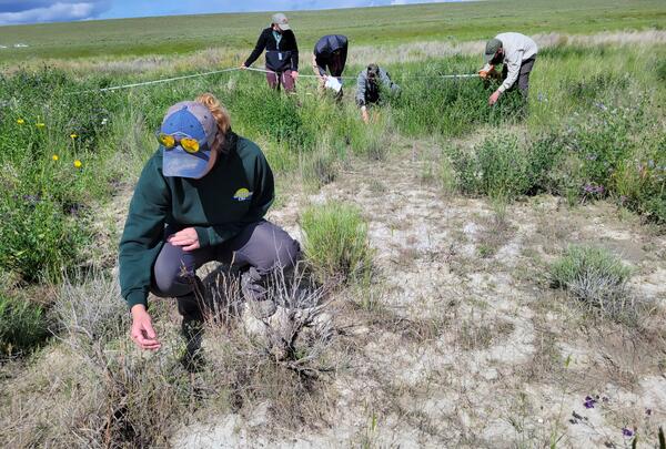
Plant community monitoring in Colorado
A USGS scientist uses the grid-point intercept method to characterize plant communities in Larimer County, Colorado. The grid-point intercept method uses points along a grid to sample plant species or ground cover within a larger plot.
A USGS scientist uses the grid-point intercept method to characterize plant communities in Larimer County, Colorado. The grid-point intercept method uses points along a grid to sample plant species or ground cover within a larger plot.

Identifying grass species in Colorado
USGS scientists identifying plant community composition in Larimer County, Colorado. Information on plant community composition is critical for understanding differences in soil carbon-responses to exotic annual grass invasion between sites.
USGS scientists identifying plant community composition in Larimer County, Colorado. Information on plant community composition is critical for understanding differences in soil carbon-responses to exotic annual grass invasion between sites.
Underside of Bell Jet Helicopter with thermal infrared and true-color image sensors and JN and M.D.
Underside of Bell Jet Helicopter with thermal infrared and true-color image sensors and JN and M.D.Underside of Bell Jet Helicopter with thermal infrared and true-color image sensors and JN and M.D. The helicopter is used for airborne surveys of river reaches to capture temperature values of water-surfaces.

Juniper tree in the Stinkingwater Mountains of Oregon
Juniper tree in the Stinkingwater Mountains of OregonA tall, partially dead western juniper (Juniperus occidentalis) surrounded by smaller, dead juniper trees. Project ROAM (Rapid and Other Methods for Assessment and Monitoring) plots are sampled across a variety of rangeland ecosystems and treatment prescriptions, including juniper removal.

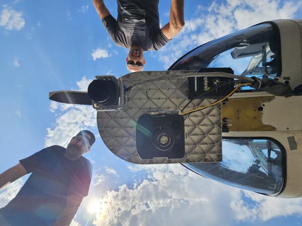
View of nose of Bell Jet Helicopter with a thermal infrared and true-color sensor co-mounted to the underside
View of nose of Bell Jet Helicopter with a thermal infrared and true-color sensor co-mounted to the undersideProfile view of a Bell Jet Helicopter with a thermal infrared and true-color sensor co-mounted to the underside of the nose. These sensors are used in airborne thermal infrared surveys for remotely sensing land/water surface temperature.
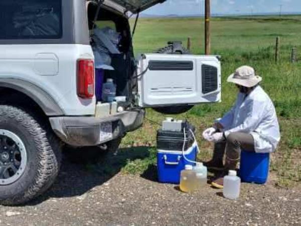
Water quality sampling near Hart Lake
USGS scientist processing water quality samples near Hart Lake. Water quality can have huge impacts on hydrologic processes, food web characteristics, and prey availability.
USGS scientist processing water quality samples near Hart Lake. Water quality can have huge impacts on hydrologic processes, food web characteristics, and prey availability.

Field sampling in Montana
A landscape of sagebrush (Artemisia tridentada) and yellow sweet clover (Melilotus officinalis) on the Charles M. Russell National Wildlife Refuge in Montana.
A landscape of sagebrush (Artemisia tridentada) and yellow sweet clover (Melilotus officinalis) on the Charles M. Russell National Wildlife Refuge in Montana.

Storm over sagebrush steppe in Montana
A storm rolls in during field work at the Charles M. Russell National Wildlife Refuge in Montana. Crews were measuring plant cover and other site characteristics. Sagebrush and yellow sweet clover are visible.
A storm rolls in during field work at the Charles M. Russell National Wildlife Refuge in Montana. Crews were measuring plant cover and other site characteristics. Sagebrush and yellow sweet clover are visible.
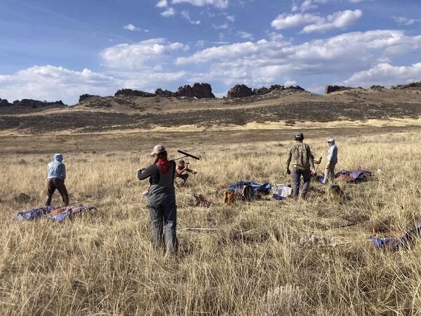
ROAM field data collection
A five-person USGS crew collecting Rapid and Other Assessment and Monitoring (ROAM) density data in southwest Idaho. One person is inspecting a plant in the foreground, while the rest of the team are identifying and counting individual plants during a radial density belt.
A five-person USGS crew collecting Rapid and Other Assessment and Monitoring (ROAM) density data in southwest Idaho. One person is inspecting a plant in the foreground, while the rest of the team are identifying and counting individual plants during a radial density belt.