
Ecosystem change science in support of wildfire management, water conservation, public land reclamation, and food security
FORT researchers provide sound science to support the Department of the Interior in its efforts to manage wildfires, conserve water, reclaim public lands for multiple uses, and promote food security.
This research is developed in partnership with resource managers from local, State, Federal and Tribal governments, industry, and nongovernmental organizations, empowering local and rural communities to make decisions for themselves using high-quality data and smart tools.
Causes and consequences of wildfire and drought
For over thirty years, FORT scientists have investigated the causes and consequences of wildfire and drought across the American southwest. Local land managers have long used this science to understand changing patterns in the region, and still rely on this research to inform effective management.
Understanding fire history to predict future forest fires
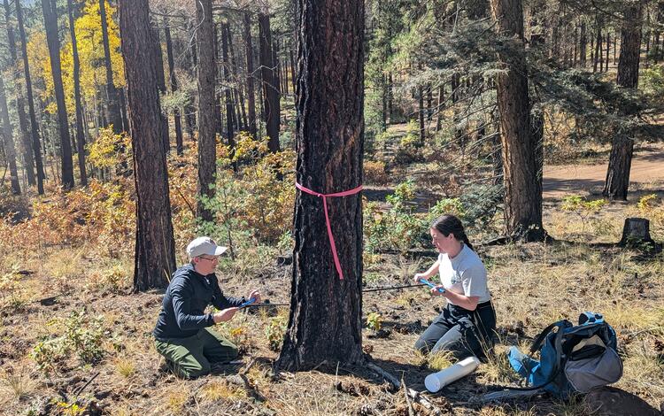
Recent forest fires are burning hotter and spreading farther than fires from the last century, devastating communities and forests, and posing new problems for land managers. Predicting when and where a dangerous wildfire will start next is difficult, but scientists at FORT’s New Mexico Landscapes Field Station are studying historical forest fire patterns to assist managers in ensuring national security through wildfire prediction and risk mitigation.

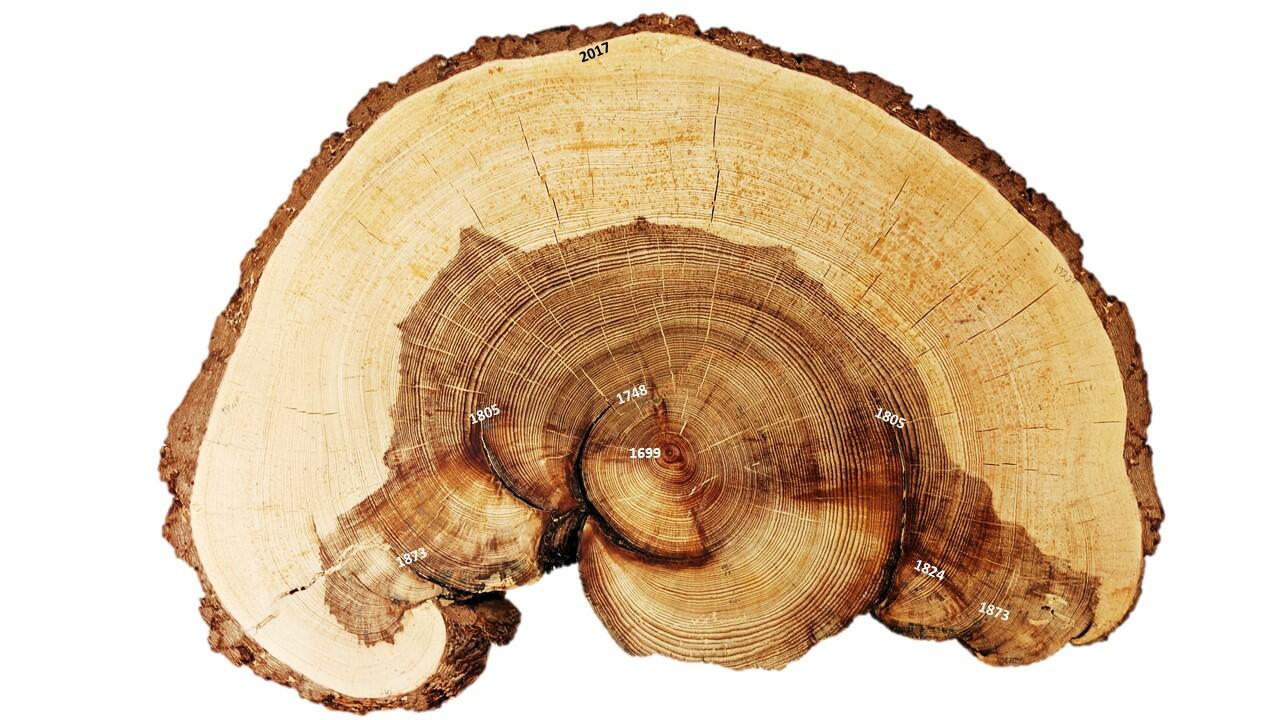
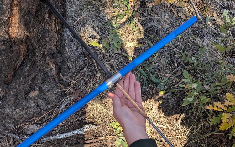
Using tree rings, scientists can learn a lot about the history of fire in a region, including when fires occurred and how severe a fire was. Lucky for scientists, there are >300,000 tree-ring fire records across North America.

Scientists at FORT worked with collaborators to compile these records, and are currently part of a group synthesizing this data to reveal forest fire patterns. Recent results of this synthesis include the finding that, although contemporary forest fires are increasing in size, they are still burning less acreage than historical fires. Findings like this can help managers prepare for future fires, ensuring public safety and effective forest management. Read more about additional FORT fire science for effective land management here.
Background: A conifer section showing tree rings and fire scars, with dates of each fire scar noted. Ellis Margolis (USGS).
Mitigating drought in the Colorado River Basin
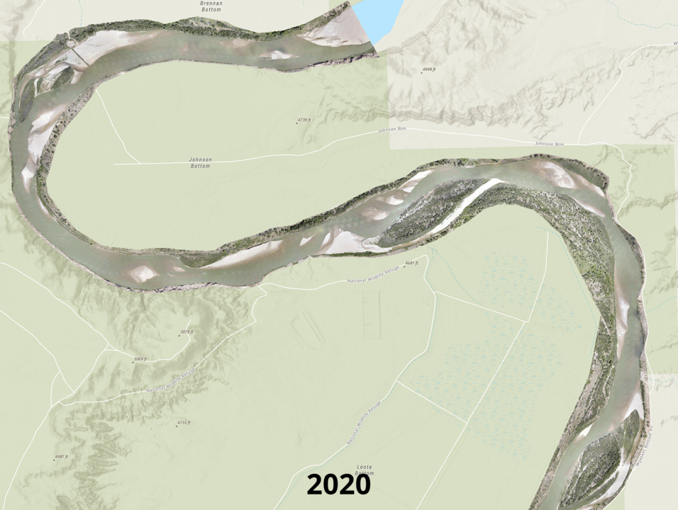
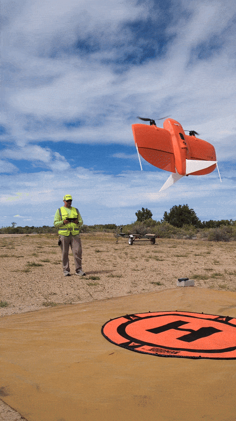
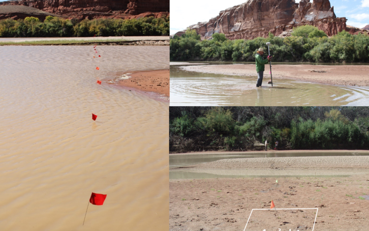
The Colorado River Basin spans seven different states in the southwestern U.S., providing water for almost 40 million people and 5.5 million acres of agricultural land. However, it has also been experiencing a decades-long drought that has negatively impacted the communities and ecosystems that depend on its water supply.
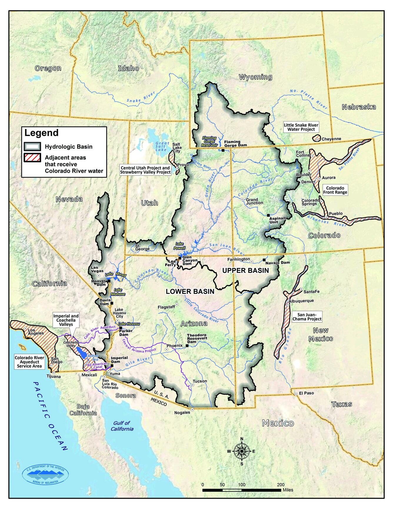
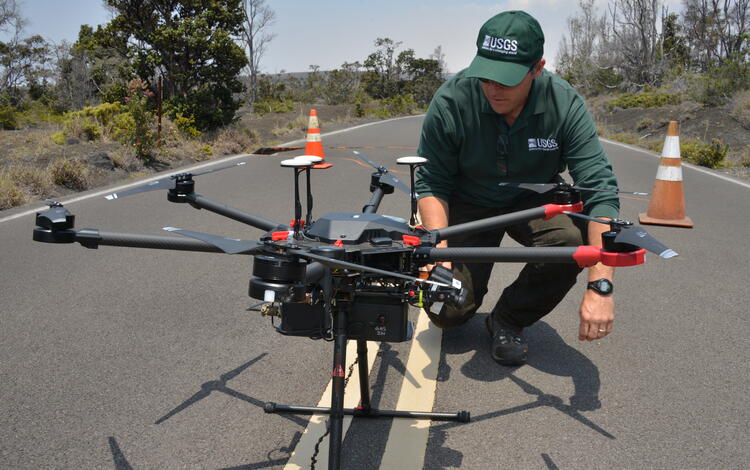
Scientists at FORT are working with many other government agencies, nongovernmental agencies, industries, Tribes, and local communities to research the effects of drought in the region, develop tools for flow management, map river channel change with uncrewed aircraft systems, conduct interdisciplinary science for decision makers, and determine where more science is needed for effective drought mitigation in the Basin.
Facilitating reclamation of public lands
The Department of Interior is dedicated to reclaiming abandoned mine lands and orphaned wells, to ensure our public lands are useful for agriculture, infrastructure, and energy development. To aid in reclamation efforts on public lands, FORT researchers worked with the Bureau of Land Management (BLM) to develop the Surface Disturbance and Reclamation Tool (SDARTT). SDARTT is the national database and analysis tool for disturbance data related to public land operations managed by the BLM, whose managers use the tool to ensure their reclamation and monitoring methods are effective. This system allows the BLM to analyze data, providing new insights into total area affected, changes over time, habitat fragmentation, and the overall success of reclamation efforts.
FORT scientists have also developed a synthesis on the use of remote sensing for mine land monitoring and recovery and a web application that maps mine lands and other geospatial data across the United States. These and other ongoing mine land reclamation projects at FORT can help managers prioritize mines for reclamation based on hazards, revegetation success, and economic feasibility.
Supporting food security and the agricultural economy
Agriculture is a vital industry in America; covering almost half of the country, agricultural lands alone contribute over 2.5 million jobs and \$200 billion to the American economy each year. Coordination of effective agricultural management practices is necessary to maintain this industry and the food it supplies into the future, and FORT scientists are assisting with just that.
On degrading agricultural lands – lands with higher soil erosion, lower water quality, or other potential issues – the US Department of Agriculture’s (USDA) Conservation Reserve Program (CRP) partners with agrarians to restore their land for a designated time. FORT scientists are working closely with the USDA to ensure practices employed by CRP are effective. To do this, they complete field studies assessing current agency priorities, like the effects of grazing on vegetation restoration, or whether planted pollinator habitat is attracting pollinators. They have also developed methods to assist land managers in assessing soil erosion, wildlife habitat, and other potential changes resulting from CRP actions. Results of this work help CRP, and the farmers and ranchers they work with, to implement successful and economical practices in support of resilient, agricultural lands and food security.
Additional Ecosystem Change Research
Many FORT research projects are interdisciplinary. On the pages below, you can learn more about additional ecosytem change research from FORT, including science for management of healthy fish and wildlife populations, science for wildfire risk reduction, and science for invasive species management.
All FORT research on Ecosystem Change
FORT research on fish and wildlife
FORT research on land management
FORT research on invasive species
FORT research on social and economic analysis
Shrubland, Alpine and Grassland Ecology (SAGE) Wildlife Research Group

Supporting energy and mineral development through successful reclamation

Economics of Wildland Fire

Land management research in support of streamlined energy development, economic growth, and wildfire management

Invasive species science in support of public safety, America’s natural resources, and economic growth

Integrated River and Riparian Ecosystem Studies

Conservation Practices in Agriculturally Dominated Landscapes

Agricultural Practices

New Mexico Tree-Ring Science

The New Mexico Landscapes Field Station

New Mexico Landscapes Field Station: Forest Ecosystem Research

New Mexico Landscapes Field Station: Fire Research
FORT researchers provide sound science to support the Department of the Interior in its efforts to manage wildfires, conserve water, reclaim public lands for multiple uses, and promote food security.
This research is developed in partnership with resource managers from local, State, Federal and Tribal governments, industry, and nongovernmental organizations, empowering local and rural communities to make decisions for themselves using high-quality data and smart tools.
Causes and consequences of wildfire and drought
For over thirty years, FORT scientists have investigated the causes and consequences of wildfire and drought across the American southwest. Local land managers have long used this science to understand changing patterns in the region, and still rely on this research to inform effective management.
Understanding fire history to predict future forest fires
Recent forest fires are burning hotter and spreading farther than fires from the last century, devastating communities and forests, and posing new problems for land managers. Predicting when and where a dangerous wildfire will start next is difficult, but scientists at FORT’s New Mexico Landscapes Field Station are studying historical forest fire patterns to assist managers in ensuring national security through wildfire prediction and risk mitigation.
Using tree rings, scientists can learn a lot about the history of fire in a region, including when fires occurred and how severe a fire was. Lucky for scientists, there are >300,000 tree-ring fire records across North America.
Scientists at FORT worked with collaborators to compile these records, and are currently part of a group synthesizing this data to reveal forest fire patterns. Recent results of this synthesis include the finding that, although contemporary forest fires are increasing in size, they are still burning less acreage than historical fires. Findings like this can help managers prepare for future fires, ensuring public safety and effective forest management. Read more about additional FORT fire science for effective land management here.
Background: A conifer section showing tree rings and fire scars, with dates of each fire scar noted. Ellis Margolis (USGS).
Mitigating drought in the Colorado River Basin
The Colorado River Basin spans seven different states in the southwestern U.S., providing water for almost 40 million people and 5.5 million acres of agricultural land. However, it has also been experiencing a decades-long drought that has negatively impacted the communities and ecosystems that depend on its water supply.
Scientists at FORT are working with many other government agencies, nongovernmental agencies, industries, Tribes, and local communities to research the effects of drought in the region, develop tools for flow management, map river channel change with uncrewed aircraft systems, conduct interdisciplinary science for decision makers, and determine where more science is needed for effective drought mitigation in the Basin.
Facilitating reclamation of public lands
The Department of Interior is dedicated to reclaiming abandoned mine lands and orphaned wells, to ensure our public lands are useful for agriculture, infrastructure, and energy development. To aid in reclamation efforts on public lands, FORT researchers worked with the Bureau of Land Management (BLM) to develop the Surface Disturbance and Reclamation Tool (SDARTT). SDARTT is the national database and analysis tool for disturbance data related to public land operations managed by the BLM, whose managers use the tool to ensure their reclamation and monitoring methods are effective. This system allows the BLM to analyze data, providing new insights into total area affected, changes over time, habitat fragmentation, and the overall success of reclamation efforts.
FORT scientists have also developed a synthesis on the use of remote sensing for mine land monitoring and recovery and a web application that maps mine lands and other geospatial data across the United States. These and other ongoing mine land reclamation projects at FORT can help managers prioritize mines for reclamation based on hazards, revegetation success, and economic feasibility.
Supporting food security and the agricultural economy
Agriculture is a vital industry in America; covering almost half of the country, agricultural lands alone contribute over 2.5 million jobs and \$200 billion to the American economy each year. Coordination of effective agricultural management practices is necessary to maintain this industry and the food it supplies into the future, and FORT scientists are assisting with just that.
On degrading agricultural lands – lands with higher soil erosion, lower water quality, or other potential issues – the US Department of Agriculture’s (USDA) Conservation Reserve Program (CRP) partners with agrarians to restore their land for a designated time. FORT scientists are working closely with the USDA to ensure practices employed by CRP are effective. To do this, they complete field studies assessing current agency priorities, like the effects of grazing on vegetation restoration, or whether planted pollinator habitat is attracting pollinators. They have also developed methods to assist land managers in assessing soil erosion, wildlife habitat, and other potential changes resulting from CRP actions. Results of this work help CRP, and the farmers and ranchers they work with, to implement successful and economical practices in support of resilient, agricultural lands and food security.
Additional Ecosystem Change Research
Many FORT research projects are interdisciplinary. On the pages below, you can learn more about additional ecosytem change research from FORT, including science for management of healthy fish and wildlife populations, science for wildfire risk reduction, and science for invasive species management.
All FORT research on Ecosystem Change
FORT research on fish and wildlife
FORT research on land management
FORT research on invasive species
FORT research on social and economic analysis
Shrubland, Alpine and Grassland Ecology (SAGE) Wildlife Research Group
Supporting energy and mineral development through successful reclamation
Economics of Wildland Fire
Land management research in support of streamlined energy development, economic growth, and wildfire management
Invasive species science in support of public safety, America’s natural resources, and economic growth
Integrated River and Riparian Ecosystem Studies
Conservation Practices in Agriculturally Dominated Landscapes
Agricultural Practices
New Mexico Tree-Ring Science
The New Mexico Landscapes Field Station
New Mexico Landscapes Field Station: Forest Ecosystem Research