
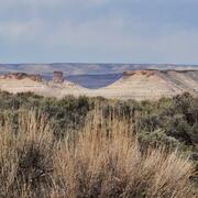
Ecosystem Change and Disturbance
Ecosystem Change and Disturbance
Learn more about FORT research on ecosystem change and disturbance.
Ecosystem change research in support of the Department of the Interior
Ecosystem change research in support of the Department of the Interior
FORT researchers provide sound science to support the Department of the Interior in its efforts to manage wildfires, conserve water, reclaim public lands for multiple uses, and promote food security.
Filter Total Items: 110
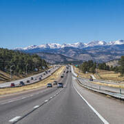
Using Artificial Intelligence to Estimate Traffic to Improve Planning and Access to Colorado’s Public Lands
This project applies data-driven, machine‑learning methods to estimate average annual daily traffic on roads that connect people to Colorado’s public lands, where traffic data are sparse or nonexistent. Expanding on successful applications in Wyoming, the approach uses socioeconomic, land-use, roadway, and accessibility data to uniquely model traffic patterns from 2015 to 2025. These predictions...
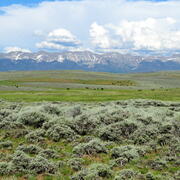
Shrubland, Alpine and Grassland Ecology (SAGE) Wildlife Research Group
The SAGE Wildlife Research Group consists of a large team of research scientists with an interest in conservation and management of wildlife and their ecosystems. Broadly, research involves understanding animal-habitat relationships, with an emphasis on conservation ecology and population demography, and a focus on shrubland, alpine, and grassland ecosystems. We are addressing the effects of...

Supporting energy and mineral development through successful reclamation
Federal lands of the US contain important reserves of oil, gas and other resources important for Unleashing American Energy (SO 3418). After development of these resources is complete, successfully reclaiming disturbed lands is a necessary step towards restoring wildlife habitat, forage production, and maintaining natural resources for future use. To improve reclamation outcomes on these lands and...
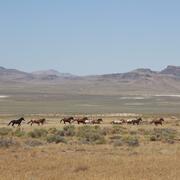
Science for management of America’s iconic wild horses and burros
Wild horses and burros are iconic wildlife of the western USA as well as a complicated management issue on tribal, state, and federal lands. Due to their history as domesticated animals, these wild equids – also called “free-roaming” or “feral” equids – can reproduce quickly, and have few natural predators, allowing their populations to grow rapidly if not managed. When populations are too large...

Data Harmonization for Greater Sage-Grouse Populations
Long-term wildlife monitoring is imperative for understanding population changes that can inform managers. However, working with population data collected by different organizations across multiple jurisdictions and over long time periods can be challenging due to varying data management approaches and organizational priorities. Through this project, we aimed to collaborate with eleven state...

Greater Sage-Grouse Population Monitoring Framework
Greater sage-grouse ( Centrocercus urophasianus) are at the center of state and national land use policies largely because of their unique life-history traits and their role as an ecological indicator for the health of sagebrush ecosystems. Multiple science centers with the U.S. Geological Survey (USGS) in conjunction with Colorado State University (CSU) have developed the Greater Sage-Grouse...

A user-friendly decision support tool for monitoring and managing greater sage-grouse populations
Researchers at the U.S. Geological Survey (USGS) and Colorado State University (CSU) collaborated with the Bureau of Land Management and state wildlife agencies to develop a hierarchical population monitoring framework for managing greater sage-grouse ( Centrocercus urophasianus) populations and the sagebrush ecosystems they depend on for survival and reproduction. This greater sage-grouse...

A targeted annual warning system (TAWS) for identifying aberrant declines in greater sage-grouse populations
Land and wildlife managers require accurate estimates of sensitive species’ trends to help guide conservation decisions that maintain biodiversity and promote healthy ecosystems. Multiple science centers with the U.S. Geological Survey (USGS), in conjunction with Colorado State University (CSU), developed a hierarchical population monitoring framework for managing greater sage-grouse (...

Estimating trends for greater sage-grouse populations within highly stochastic environments
Land and wildlife managers require accurate estimates of sensitive species’ trends to help guide conservation decisions that maintain biodiversity and promote healthy ecosystems. The U.S. Geological Survey (USGS), in conjunction with Colorado State University (CSU), developed a hierarchical population monitoring framework for managing greater sage-grouse ( Centrocercus urophasianus; sage-grouse)...
AI-driven science synthesis tools for resource managers
The scientific literature is abundant on drought-related topics in the western United States, including areas of the Colorado River Basin and the sagebrush biome. Scientists, resource managers, and decision makers use this science to assess, predict, and respond to the effects of drought on people and the environment. However, it can be difficult to quickly synthesize large amounts of research. To...

USGS Sagebrush Science: Supporting Public Safety and Economic Decision Making Across the West
The sagebrush biome is one of the largest ecosystems in North America. Encompassing nearly one-third of the continental U.S., it provides critical resources for millions of Americans and a home for hundreds of plants and animal species in the West. Natural resource management in sagebrush ecosystems can be complex, and science can support management decisions by providing knowledge and tools to...
By
Core Science Systems Mission Area, Ecosystems Mission Area, Biological Threats and Invasive Species Research Program, Climate Adaptation Science Centers, Cooperative Research Units, Land Management Research Program, Species Management Research Program, Earth Resources Observation and Science (EROS) Center, Forest and Rangeland Ecosystem Science Center, Fort Collins Science Center, Northern Rocky Mountain Science Center, Southwest Biological Science Center, Western Ecological Research Center (WERC), Wildland Fire Science

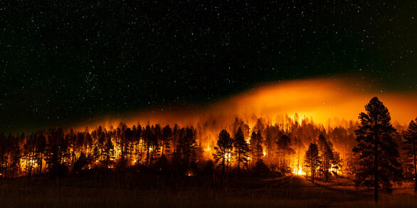
Economics of Wildland Fire
In recent decades, wildfires have increased in size and intensity, and the fire season has lengthened. This and other factors have increased wildfire suppression costs and risks to human health and safety. Economists in the Social and Economic Analysis Branch (SEA) at FORT investigate numerous aspects of wildland fire, its impacts, and how to mitigate the risk wildfire poses to people, resources...