
A tall, partially dead western juniper (Juniperus occidentalis) surrounded by smaller, dead juniper trees. Project ROAM (Rapid and Other Methods for Assessment and Monitoring) plots are sampled across a variety of rangeland ecosystems and treatment prescriptions, including juniper removal.
Multimedia
Images

Juniper tree in the Stinkingwater Mountains of Oregon
A tall, partially dead western juniper (Juniperus occidentalis) surrounded by smaller, dead juniper trees. Project ROAM (Rapid and Other Methods for Assessment and Monitoring) plots are sampled across a variety of rangeland ecosystems and treatment prescriptions, including juniper removal.

Field sampling in Montana
A landscape of sagebrush (Artemisia tridentada) and yellow sweet clover (Melilotus officinalis) on the Charles M. Russell National Wildlife Refuge in Montana.
A landscape of sagebrush (Artemisia tridentada) and yellow sweet clover (Melilotus officinalis) on the Charles M. Russell National Wildlife Refuge in Montana.

Storm over sagebrush steppe in Montana
A storm rolls in during field work at the Charles M. Russell National Wildlife Refuge in Montana. Crews were measuring plant cover and other site characteristics. Sagebrush and yellow sweet clover are visible.
A storm rolls in during field work at the Charles M. Russell National Wildlife Refuge in Montana. Crews were measuring plant cover and other site characteristics. Sagebrush and yellow sweet clover are visible.
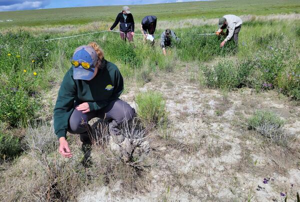
ROAM field data collection
A five-person USGS crew collecting Rapid and Other Assessment and Monitoring (ROAM) density data in southwest Idaho. One person is inspecting a plant in the foreground, while the rest of the team are identifying and counting individual plants during a radial density belt.
A five-person USGS crew collecting Rapid and Other Assessment and Monitoring (ROAM) density data in southwest Idaho. One person is inspecting a plant in the foreground, while the rest of the team are identifying and counting individual plants during a radial density belt.

Downward facing photo within a ROAM plot
A downward-facing photo taken on a Rapid and Other Methods for Assessment and Monitoring (ROAM) plot that is within a fuel break. The photo includes a lot of gravel and bare ground, with intermixed small grasses, forbs, and shrubs.
A downward-facing photo taken on a Rapid and Other Methods for Assessment and Monitoring (ROAM) plot that is within a fuel break. The photo includes a lot of gravel and bare ground, with intermixed small grasses, forbs, and shrubs.

Shore of Lake Abert, Oregon
Lake Abert, Oregon is one of the 20 terminal lakes identified by USGS partners as priority ecosystems for study by the Saline Lakes Ecosystems IWAA.
By
Ecosystems Mission Area, Water Resources Mission Area, Forest and Rangeland Ecosystem Science Center, Fort Collins Science Center, Nevada Water Science Center, Oregon Water Science Center, Utah Water Science Center, Western Ecological Research Center (WERC), Saline Lake Ecosystems Integrated Water Availability Assessment
Videos

Conservation Efforts Database — Registration
This video shows you how to register for access to the Conservation Efforts Database, update your user profile, and navigate the site’s resources.
This video shows you how to register for access to the Conservation Efforts Database, update your user profile, and navigate the site’s resources.
Conservation Efforts Database — Single Record Data Entry Step 1
This video is step 1 in a series of videos that show you how to enter data into the Conservation Efforts Database using the single record data entry method. Step 1 is the creation of a new conservation effort.
This video is step 1 in a series of videos that show you how to enter data into the Conservation Efforts Database using the single record data entry method. Step 1 is the creation of a new conservation effort.
Conservation Efforts Database — Single Record Data Entry Step 2 (Public Lands)
This video is step 2 in a series of videos that show you how to enter data into the Conservation Efforts Database using the single record data entry method. Step 2 is data entry of location information. This video is for data entry of location information for conservation efforts on public lands.
This video is step 2 in a series of videos that show you how to enter data into the Conservation Efforts Database using the single record data entry method. Step 2 is data entry of location information. This video is for data entry of location information for conservation efforts on public lands.
Conservation Efforts Database — Single Record Data Entry Step 2 (Private Lands)
This video is step 2 in a series of five videos that show you how to enter data into the Conservation Efforts Database using the single record data entry method. Step 2 is data entry of location information. This video is for data entry of location information for conservation efforts on private lands.
This video is step 2 in a series of five videos that show you how to enter data into the Conservation Efforts Database using the single record data entry method. Step 2 is data entry of location information. This video is for data entry of location information for conservation efforts on private lands.
Conservation Efforts Database — Single Record Data Entry Step 3: Activity Information – Cutthroat Trout Recovery Module
linkThis video is step 3 in a series of videos that show you how to enter data into the Conservation Efforts Database using the single record data entry method. Step 2 is data entry activity information. This video is for data entry of activity information related to Lahontan Cutthroat Trout conservation efforts.
Conservation Efforts Database — Single Record Data Entry Step 4
This video is step 4 in a series of videos that show you how to enter data into the Conservation Efforts Database using the single record data entry method. Step 4 is data entry of implementation information.
This video is step 4 in a series of videos that show you how to enter data into the Conservation Efforts Database using the single record data entry method. Step 4 is data entry of implementation information.
Audio

Who's Your Mama? Conservation Genetics and At-Risk Species
USGS science supports management, conservation, and restoration of imperiled, at-risk, and endangered species. Endangered Species Day is commemorated in May, and we’re taking some time to find out just how one goes about studying at-risk species and what part cutting-edge technologies can play in helping us do the science that informs managers and policy makers.
USGS science supports management, conservation, and restoration of imperiled, at-risk, and endangered species. Endangered Species Day is commemorated in May, and we’re taking some time to find out just how one goes about studying at-risk species and what part cutting-edge technologies can play in helping us do the science that informs managers and policy makers.

Oregon Songbirds: Singing for Their Supper in Evergreen Forests
In this episode we sit down with USGS wildlife biologist Joan Hagar and discuss her recent study on songbirds in the Pacific Northwest. New research indicates a possible relationship between reductions in the abundance of some species of songbird and reductions in the amount of deciduous trees in evergreen forests.
In this episode we sit down with USGS wildlife biologist Joan Hagar and discuss her recent study on songbirds in the Pacific Northwest. New research indicates a possible relationship between reductions in the abundance of some species of songbird and reductions in the amount of deciduous trees in evergreen forests.
Unearthing the Secrets Beneath the Forest Floor
There is a black box hidden beneath the forests of the Pacific Northwest, guarding the secrets to why the trees grow so large! The black box is soil, which harbors immense biological diversity and controls the release of water and nutrients that support the life above ground.
There is a black box hidden beneath the forests of the Pacific Northwest, guarding the secrets to why the trees grow so large! The black box is soil, which harbors immense biological diversity and controls the release of water and nutrients that support the life above ground.
To Burn or Not to Burn? A Framework to Answer the Question
Prescribed burns are a common tool used by land managers to control invasive plant species and to promote native plants. There are many benefits to using a prescribed burn as a management tool; however, controlling fire is often difficult as it can be unpredictable.
Prescribed burns are a common tool used by land managers to control invasive plant species and to promote native plants. There are many benefits to using a prescribed burn as a management tool; however, controlling fire is often difficult as it can be unpredictable.
Drab Appearance Masks Complexity of Imperiled Sagebrush Ecosystems
Compared to the rich diversity of forests, sagebrush shrublands contain relatively few species. Yet, these shrublands in the western United States have incredibly complex dynamics that present major challenges for conservation. They are also one of the most imperiled habitats in North America, primarily due to invasive plant species.
Compared to the rich diversity of forests, sagebrush shrublands contain relatively few species. Yet, these shrublands in the western United States have incredibly complex dynamics that present major challenges for conservation. They are also one of the most imperiled habitats in North America, primarily due to invasive plant species.
Fatal Frog Fungus
The potentially lethal fungal disease chytridiomycosis has been associated with declining amphibian populations around the globe. This rapidly emerging disease, and the chytrid fungus that causes it, have forced scientists to scramble to learn more. There are still plenty of mysteries about the origin and spread of the fungus.
The potentially lethal fungal disease chytridiomycosis has been associated with declining amphibian populations around the globe. This rapidly emerging disease, and the chytrid fungus that causes it, have forced scientists to scramble to learn more. There are still plenty of mysteries about the origin and spread of the fungus.