
Anacostia Ground Water Study Project
Our goal is to develop an understanding of the hydrogeologic framework, determine the extent of groundwater/surface water interactions, and to estimate the contributions of contaminants from the groundwater to the lower tidal Anacostia River in Washington, D.C.
The Anacostia River has been subjected to dredging, filling, contamination, and other human influences for over 200 years. As a result of these activities, the river has been seriously degraded from its natural state. Many groups have been working to reduce the effects of environmental degradation on the water quality and living resources of the Anacostia River, primarily by focusing on toxic contamination in river sediments. Other sources of contaminants to the Anacostia, including those from combined sewage outfalls and from ground water, are beginning to attract attention from investigators interested in addressing the environmental problems in the area.
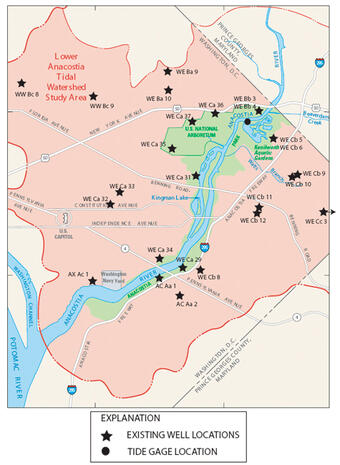
Groundwater hydrogeology in the lower Anacostia tidal watershed is not well characterized, and is possibly a source of contaminants to the river. Because of the urban nature of the watershed and the long history of industrial and residential development in the area, it is likely that ground water in the area is contaminated. However, little is known about the background groundwater quality, the types of non-point source contaminants in the ground water, the characteristics of ground-water flow, or the volumetric flux of ground water and associated contaminants to the river. Because of the many modifications to the river system (including bulkheads, dredging, filling, engineered wetlands, storm drains, and leaky infrastructure), ground-water interactions with the river are complex and difficult to characterize. It is therefore important to use a wide variety of investigative tools to help characterize the ground-water flow system, the ground-water quality, and the ground- and surface-water interactions.
----Strategy and Approach----
- Maintaining a ground-water monitoring network in the lower Anacostia watershed is critical to the successful completion of the project.
- Collect water-quality data from wells. Constituents, will include VOCs, semivolatiles, pesticides, PCBs, total metals, mercury, total cyanide, total phenols, total suspended solids, total dissolved solids, chemical oxygen demand, BOD, oil and grease, TKN, and nutrients.
- Examine existing groundwater level data for temporal or spatial trends or patterns. Develop a series of hydrogeologic cross sections in the lower Anacostia tidal watershed.
- Collect water-level data and determine aquifer properties in new and existing monitoring wells using single-well slug tests or multi-well pumping tests.
- Borehole geophysical data (gamma logs) will be collected for each well that can be accessed by the appropriate equipment.
- Evaluate ground-water contaminant loads to the lower Anacostia River.