
The graph shows historic pumping over time in Carson Valley, NV. Between the 1970s and early 2000’s, Carson Valley underwent rapid population growth and total pumping increased by an order of magnitude, from 3,360 acre-feet in 1970 to 31,100 in 2004.
Images
Images intro.
Filter Total Items: 81

Historic pumping over time Carson Valley, NV
The graph shows historic pumping over time in Carson Valley, NV. Between the 1970s and early 2000’s, Carson Valley underwent rapid population growth and total pumping increased by an order of magnitude, from 3,360 acre-feet in 1970 to 31,100 in 2004.

East Fork Carson River below Markleeville Creek near Markleeville, CA
East Fork Carson River below Markleeville Creek near Markleeville, CAEarly spring at monitoring location USGS 10308200 East Fork Carson River below Markleeville Creek near Markleeville, CA.
East Fork Carson River below Markleeville Creek near Markleeville, CA
East Fork Carson River below Markleeville Creek near Markleeville, CAEarly spring at monitoring location USGS 10308200 East Fork Carson River below Markleeville Creek near Markleeville, CA.
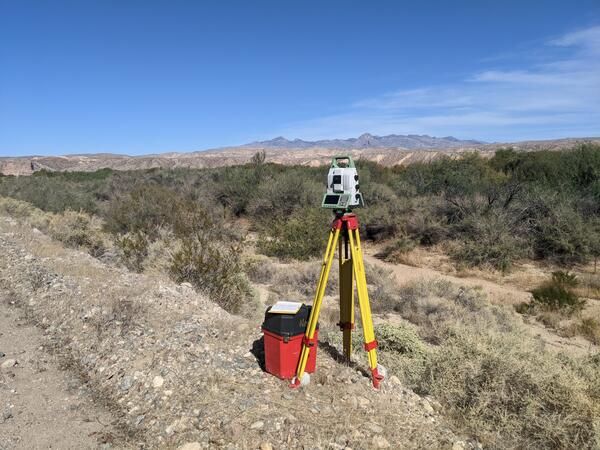
Terrestrial laser scanner survey of floodplain at Stuart Ranch, near Rox, Nevada
Terrestrial laser scanner survey of floodplain at Stuart Ranch, near Rox, NevadaSurveying a floodplain at Stuart Ranch, near Rox, Nevada, with a terrestrial laser scanner. The scanner collects millions of points to build a 3D map of the land surface.

Ruby Lake National Wildlife Reserve
Ruby Lake National Wildlife Refuge lies at the southern end of Ruby Valley in northeast Nevada. For more information visit the Ruby Lake NWR website.
By
Ecosystems Mission Area, Water Resources Mission Area, Land Management Research Program, Water Availability and Use Science Program, Climate Adaptation Science Centers, Forest and Rangeland Ecosystem Science Center, Fort Collins Science Center, Nevada Water Science Center, Oregon Water Science Center, Utah Water Science Center, Western Ecological Research Center (WERC), Saline Lakes Ecosystems Integrated Water Availability Assessment

Water year 2021 streamflow summary for the Upper Truckee River at South Lake Tahoe, USGS Site 10336610.
Water year 2021 streamflow summary for the Upper Truckee River at South Lake Tahoe, USGS Site 10336610.Water year 2020 streamflow summary for the Upper Truckee River at South Lake Tahoe, USGS Site 10336610.

Third Creek, NV
View of near shore Third Creek, NV
View of near shore Third Creek, NV

USGS Nevada Groundwater Site 393310114475001
Did you know the USGS has been studying groundwater since we were founded? USGS first measured the groundwater level at the well in this photo in 1918, over one hundred years ago! How often water levels are measured at a site in the USGS groundwater monitoring networks varies, depending on the scientific purpose of the measurement.
Did you know the USGS has been studying groundwater since we were founded? USGS first measured the groundwater level at the well in this photo in 1918, over one hundred years ago! How often water levels are measured at a site in the USGS groundwater monitoring networks varies, depending on the scientific purpose of the measurement.

collecting eDNA samples
A USGS Hydrologic Technician collects eDNA samples alongside a stream in the Nevada wilderness
A USGS Hydrologic Technician collects eDNA samples alongside a stream in the Nevada wilderness
Fen in Big Smoky Valley
Photo of a fen, a small groundwater-fed wetland in desert environment that can provide habitat for plants and animals.
Photo of a fen, a small groundwater-fed wetland in desert environment that can provide habitat for plants and animals.
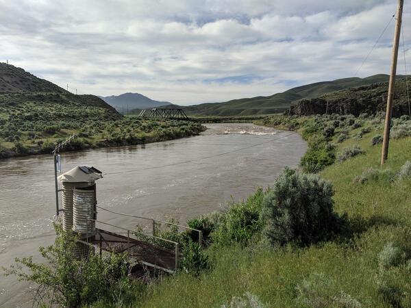
Humboldt River at Palisade
Photo shows the USGS Humboldt River at Palisade, NV streamgage.
Photo shows the USGS Humboldt River at Palisade, NV streamgage.

Carson River below Lahontan Reservoir near Fallon, NV
Carson River below Lahontan Reservoir near Fallon, NVView looking downstream of Lahontan Reservoir. Monitoring location USGS 10312150 Carson River below Lahontan Reservoir near Fallon, NV measures streamflow releases from Lahontan Dam.
Carson River below Lahontan Reservoir near Fallon, NV
Carson River below Lahontan Reservoir near Fallon, NVView looking downstream of Lahontan Reservoir. Monitoring location USGS 10312150 Carson River below Lahontan Reservoir near Fallon, NV measures streamflow releases from Lahontan Dam.

Wild horses in the Virginia City Highlands, Nev.
Wild horses in the Virginia City Highlands, Nev.
Wild horses in the Virginia City Highlands, Nev.

USGS Streamgaging Station in northern Nevada.
USGS Streamgaging Station in northern Nevada.
USGS Streamgaging Station in northern Nevada.

Measuring streamflow in northern Nevada.
USGS technician measuring streamflow in northern Nevada.
USGS technician measuring streamflow in northern Nevada.

Well pumping as part of an aquifer test in Lovelock Valley, Nevada
Well pumping as part of an aquifer test in Lovelock Valley, NevadaWell pumping as part of an aquifer test in Lovelock Valley, Nevada.
Well pumping as part of an aquifer test in Lovelock Valley, Nevada
Well pumping as part of an aquifer test in Lovelock Valley, NevadaWell pumping as part of an aquifer test in Lovelock Valley, Nevada.

USGS staff gage measuring the height of the water in the Carson River
USGS staff gage measuring the height of the water in the Carson RiverUSGS staff gage (ruler) measuring the height of the water, on the Carson River, near Brunswick Canyon, Nevada.
USGS staff gage measuring the height of the water in the Carson River
USGS staff gage measuring the height of the water in the Carson RiverUSGS staff gage (ruler) measuring the height of the water, on the Carson River, near Brunswick Canyon, Nevada.

Carson River Next to Morgan Mill Rd
Flood water on Carson River near Nevada Water Science Center Office.
Flood water on Carson River near Nevada Water Science Center Office.

Streamgaging on Martin Creek in Nevada
Streamgaging on Martin Creek, near Paradise Valley, Nevada.
Streamgaging on Martin Creek, near Paradise Valley, Nevada.

Acoustic Doppler Current Profiler
A U.S. Geological Survey field crew uses an Acoustic Doppler Current Profiler to measure water velocity on the Truckee River in Reno, Nevada.
A U.S. Geological Survey field crew uses an Acoustic Doppler Current Profiler to measure water velocity on the Truckee River in Reno, Nevada.

Flood in 2017 along Carson River, Nevada
Flood in 2017 along Carson River, Nevada.
Flood in 2017 along Carson River, Nevada.