
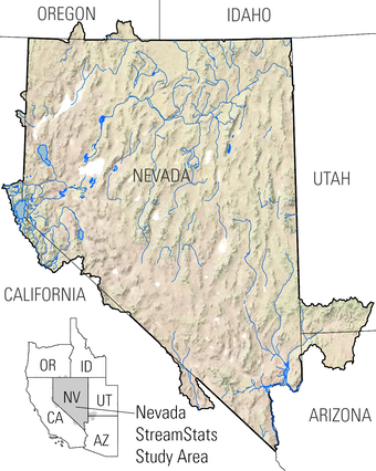
The USGS Nevada Water Science Center (NVWSC), in partnership with the Bureau of Land Management (BLM) and the Nevada Division of Water Resources (NDWR), is updating streamflow statistics for Nevada. Additionally, the project includes launching StreamStats, a web-based Geographic Information Systems (GIS) tool that provides streamflow statistics and information about drainage basins. Work on this project will continue through 2028.
Problem
Streamflow statistics are important for many stakeholders in Nevada. Monthly and annual average streamflow show how much water is generally available during various streamflow conditions. Low flow frequencies help determine how much water is likely to be in streams during low flow conditions, which is when conflicts between water supply and demand are most likely to occur.
Peak flow frequencies, also called flood frequencies, such as the 10-year and 100-year peak flows, are essential for engineers. Engineers use this information to design bridges, culverts, spillways, and other structures that manage streamflow, as well as to size reservoirs correctly. County and city planners rely on peak-flow frequencies for land-use planning, hazard assessments, and emergency preparedness.
At locations with gaging station, streamflow statistics can be directly computed. Monthly and annual average streamflow and low-flow frequencies were last calculated for Nevada by Schroer and Moosburner in 1978. Peak-flow frequencies at stream gages were last calculated for Nevada by Thomas and others in 1997.
Streamflow statistics are often needed at places without gaging stations. In these cases, estimates can be made using regional regression equations (RRE) based on similar areas with established gages. RREs can be used to estimate different streamflow statistics, but in Nevada they have been developed statewide for peak flow (Thomas and others, 1997) and only small areas of the state for flow durations and mean flows (Myers and Swanson, 1996; Hess, 1999; Hess, 2002).
A drainage basin at any point on a stream has specific features known as basin characteristics. Common basin characteristics include the drainage area, average basin elevation, average precipitation, and the percentage of the watershed covered by different land types.
StreamStats allows users to quickly access streamflow statistics, basin characteristics, and descriptive information for USGS stream gage stations and at any user-selected ungaged site along a stream.
Purpose and Scope
This project will update selected streamflow statistics and basin characteristics for Nevada using a consistent and automated method provided by the USGS StreamStats web application. StreamStats is user-friendly and only requires users to click on a map to identify the stream site of interest:
- Users can click on a stream gage symbol to access links to streamflow statistics in the StreamStats database and the available data in National Water Information System (NWIS).
- If the stream site is ungaged, the web tool will automatically outline the basin boundary and allow users to adjust the basin as needed. Users can also determine basin characteristics, calculate streamflow statistics, and download a report that includes a map of the basin, a summary of streamflow statistics with confidence intervals, and explanations of the results.
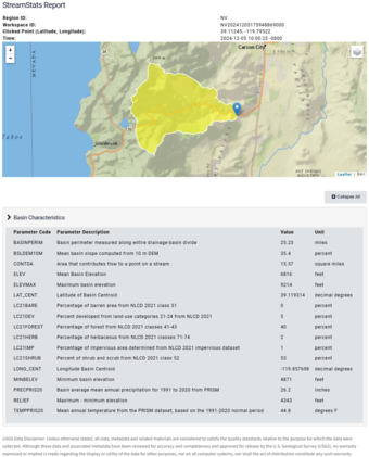
Calculated basin characteristics include:
- Drainage area, mean basin slope, mean basin elevation, and relief from the 3D Elevation Program (3DEP).
- Annual precipitation from the Parameter-Elevation Regressions on Independent Slopes Model (PRISM).
- Land cover percentages of forest, urban areas, impervious surfaces, shrubs, herbaceous plants, and bare ground from the National Land Cover Dataset.
Streamflow statistics to be calculated for stream gages in Nevada with at least 10 years of data include:
- Flow-duration statistics for monthly and annual discharge at the 1st, 10th, 25th, 50th, 75th, 90th, and 99th percentiles.
- Monthly and annual mean, minimum, and maximum streamflow.
- Annual low flow with a 10% non-exceedance probability over a consecutive 1-day (1Q10) and 7-day (7Q10) period.
- Peak flow frequencies for flood streamflow with a 50%, 20%, 10%, 4%, 2%, and 1% annual exceedance probability.
Basin characteristics and streamflow statistics at gaged sites will be used to develop RREs for estimating annual streamflow, annual low flow, and peak flow frequencies for ungaged locations. This work is expected to be completed in 2027 for annual and low flow statistics and 2028 for peak flow frequencies.
The results will be published in the Nevada StreamStats application and in a U.S. Geological Scientific Investigations Report.
References
Hess, G.W., 1999, Hydrologic data for water years 1978-97 used in daily flow-routing and river-operations models from the upper Carson River basin, California and Nevada: U.S. Geological survey Open File Report 99-256, 16 p., accessed February 14, 2019 at https://doi.org/10.3133/ofr99256
Hess, G.W., 2002, Updated techniques for estimating monthly streamflow-duration characteristics at ungaged and partial-record sites in central Nevada: U.S. Geological Survey Open File Report 2002-168, 13 p., [Also available at https://doi.org/10.3133/ofr02168]
Myers, T.J. and Swanson, S., 1996, Long-term aquatic habitat restoration: Mahogany Creek, Nevada, as a case study, Water Resources Bulletin, v. 32, n. 2, p. 241-252, accessed February 14, 2019 at https://doi.org/10.1111/j.1752-1688.1996.tb03448.x
Schroer, C.V. and Moosburner, O., 1978, Nevada streamflow characteristics: Nevada Division of Water Resources, Water Resources Information Series Report 28, 478 p., accessed February 13, 2019 at https://images.water.nv.gov/images/publications/Information%20series/28.pdf
Thomas, B,E., Hjalmarson, H.W., and Waltemeyer, S.D., 1997, Methods for estimating magnitude and frequency of floods in the southwestern United States: U.S. Geological Survey Water-Supply Paper 2433, 195 p. [Also available at https://doi.org/10.3133/wsp2433]
The USGS Nevada Water Science Center (NVWSC), in partnership with the Bureau of Land Management (BLM) and the Nevada Division of Water Resources (NDWR), is updating streamflow statistics for Nevada. Additionally, the project includes launching StreamStats, a web-based Geographic Information Systems (GIS) tool that provides streamflow statistics and information about drainage basins. Work on this project will continue through 2028.
Problem
Streamflow statistics are important for many stakeholders in Nevada. Monthly and annual average streamflow show how much water is generally available during various streamflow conditions. Low flow frequencies help determine how much water is likely to be in streams during low flow conditions, which is when conflicts between water supply and demand are most likely to occur.
Peak flow frequencies, also called flood frequencies, such as the 10-year and 100-year peak flows, are essential for engineers. Engineers use this information to design bridges, culverts, spillways, and other structures that manage streamflow, as well as to size reservoirs correctly. County and city planners rely on peak-flow frequencies for land-use planning, hazard assessments, and emergency preparedness.
At locations with gaging station, streamflow statistics can be directly computed. Monthly and annual average streamflow and low-flow frequencies were last calculated for Nevada by Schroer and Moosburner in 1978. Peak-flow frequencies at stream gages were last calculated for Nevada by Thomas and others in 1997.
Streamflow statistics are often needed at places without gaging stations. In these cases, estimates can be made using regional regression equations (RRE) based on similar areas with established gages. RREs can be used to estimate different streamflow statistics, but in Nevada they have been developed statewide for peak flow (Thomas and others, 1997) and only small areas of the state for flow durations and mean flows (Myers and Swanson, 1996; Hess, 1999; Hess, 2002).
A drainage basin at any point on a stream has specific features known as basin characteristics. Common basin characteristics include the drainage area, average basin elevation, average precipitation, and the percentage of the watershed covered by different land types.
StreamStats allows users to quickly access streamflow statistics, basin characteristics, and descriptive information for USGS stream gage stations and at any user-selected ungaged site along a stream.
Purpose and Scope
This project will update selected streamflow statistics and basin characteristics for Nevada using a consistent and automated method provided by the USGS StreamStats web application. StreamStats is user-friendly and only requires users to click on a map to identify the stream site of interest:
- Users can click on a stream gage symbol to access links to streamflow statistics in the StreamStats database and the available data in National Water Information System (NWIS).
- If the stream site is ungaged, the web tool will automatically outline the basin boundary and allow users to adjust the basin as needed. Users can also determine basin characteristics, calculate streamflow statistics, and download a report that includes a map of the basin, a summary of streamflow statistics with confidence intervals, and explanations of the results.
Calculated basin characteristics include:
- Drainage area, mean basin slope, mean basin elevation, and relief from the 3D Elevation Program (3DEP).
- Annual precipitation from the Parameter-Elevation Regressions on Independent Slopes Model (PRISM).
- Land cover percentages of forest, urban areas, impervious surfaces, shrubs, herbaceous plants, and bare ground from the National Land Cover Dataset.
Streamflow statistics to be calculated for stream gages in Nevada with at least 10 years of data include:
- Flow-duration statistics for monthly and annual discharge at the 1st, 10th, 25th, 50th, 75th, 90th, and 99th percentiles.
- Monthly and annual mean, minimum, and maximum streamflow.
- Annual low flow with a 10% non-exceedance probability over a consecutive 1-day (1Q10) and 7-day (7Q10) period.
- Peak flow frequencies for flood streamflow with a 50%, 20%, 10%, 4%, 2%, and 1% annual exceedance probability.
Basin characteristics and streamflow statistics at gaged sites will be used to develop RREs for estimating annual streamflow, annual low flow, and peak flow frequencies for ungaged locations. This work is expected to be completed in 2027 for annual and low flow statistics and 2028 for peak flow frequencies.
The results will be published in the Nevada StreamStats application and in a U.S. Geological Scientific Investigations Report.
References
Hess, G.W., 1999, Hydrologic data for water years 1978-97 used in daily flow-routing and river-operations models from the upper Carson River basin, California and Nevada: U.S. Geological survey Open File Report 99-256, 16 p., accessed February 14, 2019 at https://doi.org/10.3133/ofr99256
Hess, G.W., 2002, Updated techniques for estimating monthly streamflow-duration characteristics at ungaged and partial-record sites in central Nevada: U.S. Geological Survey Open File Report 2002-168, 13 p., [Also available at https://doi.org/10.3133/ofr02168]
Myers, T.J. and Swanson, S., 1996, Long-term aquatic habitat restoration: Mahogany Creek, Nevada, as a case study, Water Resources Bulletin, v. 32, n. 2, p. 241-252, accessed February 14, 2019 at https://doi.org/10.1111/j.1752-1688.1996.tb03448.x
Schroer, C.V. and Moosburner, O., 1978, Nevada streamflow characteristics: Nevada Division of Water Resources, Water Resources Information Series Report 28, 478 p., accessed February 13, 2019 at https://images.water.nv.gov/images/publications/Information%20series/28.pdf
Thomas, B,E., Hjalmarson, H.W., and Waltemeyer, S.D., 1997, Methods for estimating magnitude and frequency of floods in the southwestern United States: U.S. Geological Survey Water-Supply Paper 2433, 195 p. [Also available at https://doi.org/10.3133/wsp2433]