
New England WSC Products in the Third Quarter of 2025
By New England Water Science Center
September 26, 2025
List of products from the New England Water Science Center released in the third quarter of 2025.
Related
Hydrologic Monitoring Branch
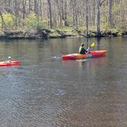
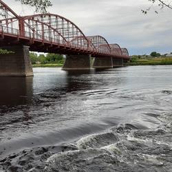
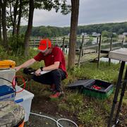
The Hydrologic Monitoring Branch (HMB) provides water data for all six New England states through an expansive network of monitoring locations. The HMB is responsible for a wide range of hydrologic monitoring activities, including collecting and analyzing streamflow, groundwater and coastal water levels, precipitation, and continuous water-quality information, such as water temperature and...

Applied Hydrology Branch
The Applied Hydrology Branch provides hydrologic data, research, and tools to water resource managers, stakeholders and policy makers that inform critical water management decisions throughout New England. This branch is divided into the Hydrology and Hydraulics Section, Water Quality Networks Section, Connecticut Water Quality Monitoring Section, and Massachusetts/Rhode Island Water Quality...
Hydrologic Interpretive Branch
The Hydrologic Interpretive Branch collaborates with stakeholders to design, execute, and publish scientific studies that address issues associated with water resources at local, regional, and national scales. This branch has three sections that focus on watershed and urban hydrology, integrated modeling of hydrologic systems, and the development of new statistical and geospatial tools.
Changes in Nitrogen Contributions from Groundwater to the Niantic River Before and After Sewering
Onsite residential septic systems can be a major nonpoint source of nitrogen contamination. The excess nitrogen entering Connecticut’s Niantic River estuary is associated with high nitrate concentrations in the groundwater of the river’s 28-square-mile watershed, creating unsuitable habitat for the growth and recovery of eelgrass (Zostera marina). In an attempt to improve the river’s water quality...

USGS New England Water Science Center Priorities and Programs
A look at what USGS water science centers do and the New England Water Science Center's current areas of focus and research.
Related
Hydrologic Monitoring Branch
The Hydrologic Monitoring Branch (HMB) provides water data for all six New England states through an expansive network of monitoring locations. The HMB is responsible for a wide range of hydrologic monitoring activities, including collecting and analyzing streamflow, groundwater and coastal water levels, precipitation, and continuous water-quality information, such as water temperature and...
Applied Hydrology Branch
The Applied Hydrology Branch provides hydrologic data, research, and tools to water resource managers, stakeholders and policy makers that inform critical water management decisions throughout New England. This branch is divided into the Hydrology and Hydraulics Section, Water Quality Networks Section, Connecticut Water Quality Monitoring Section, and Massachusetts/Rhode Island Water Quality...
Hydrologic Interpretive Branch
The Hydrologic Interpretive Branch collaborates with stakeholders to design, execute, and publish scientific studies that address issues associated with water resources at local, regional, and national scales. This branch has three sections that focus on watershed and urban hydrology, integrated modeling of hydrologic systems, and the development of new statistical and geospatial tools.
Changes in Nitrogen Contributions from Groundwater to the Niantic River Before and After Sewering
Onsite residential septic systems can be a major nonpoint source of nitrogen contamination. The excess nitrogen entering Connecticut’s Niantic River estuary is associated with high nitrate concentrations in the groundwater of the river’s 28-square-mile watershed, creating unsuitable habitat for the growth and recovery of eelgrass (Zostera marina). In an attempt to improve the river’s water quality...
USGS New England Water Science Center Priorities and Programs
A look at what USGS water science centers do and the New England Water Science Center's current areas of focus and research.