
Climatic warming since the end of the Little Ice Age has resulted in substantial glacier ice loss around the world. Most glaciers have undergone thinning and many exhibit retreat at their margins. Glacier loss triggers a cascade of hydrological and ecological effects that impact plants, animals and can create human hazard and economic hardship. USGS scientists are using a variety of methods and technologies to track glacier change in glacierized regions in North America. By understanding the link between climate and glacier loss scientists aim to enhance preparedness as increasing temperatures influence mountain ecosystems worldwide.
Benchmark Glacier Fact Sheet
The U.S. Geological Survey Benchmark Glacier Project combines decades of direct glaciological data with remote sensing data to advance the quantitative understanding of glacier-climate interactions.
Glacier-Climate Connection

The Glacier-Climate Connection geonarrative tells the story of the U.S. Geological Survey Benchmark Glacier Project, one of the longest running studies of glaciers on Earth.
USGS Glacier Research - Climate Change in Mountain Ecosystems (CCME)
Understanding Climate Drivers – The loss of glaciers has far-reaching physical and ecological consequences that impact society. Glaciers are sensitively linked to climate, yet predicting exact glacier response to regional and local climate conditions requires research. Understanding glacier response to climate helps natural resource managers and policy makers prepare for change.
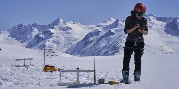
Glacier Monitoring - USGS scientists use emerging technologies to advance understanding of physical properties and the influence of climate variability on glacier loss.
USGS Benchmark Glacier Studies - Long-term mass balance research among five benchmark glaciers (including Sperry Glacier, GNP) advances our understanding of glacier-climate interactions and glacier processes. New fact sheet provides overview of USGS Benchmark Glacier Program.
Status of Glaciers in Glacier National Park- Glacier studies specific to the glaciers of Glacier National Park, MT.
Repeat Photography Project - Photographic documentation of glacier change in Glacier National park, MT.
Related Links:
Back to CCME
Below are other science projects associated with this project.

Science in Glacier National Park

Time Series of Glacier Retreat

Repeat Photography Project

Status of Glaciers in Glacier National Park

Glacier Monitoring Studies
Below are multimedia items associated with this project.

Below are FAQ associated with this project.
How do we know glaciers are shrinking? How do we know glaciers are shrinking?
Repeat photography and aerial / satellite photo analysis provide evidence of glacier loss in terms of shape and area. The USGS Benchmark Glacier project has collected mass balance data on a network of glaciers in Alaska, Washington, and Montana for decades, quantifying trends of mass loss at all sites. Extensive field data collection at these sites includes twice yearly visits to measure seasonal...
Climatic warming since the end of the Little Ice Age has resulted in substantial glacier ice loss around the world. Most glaciers have undergone thinning and many exhibit retreat at their margins. Glacier loss triggers a cascade of hydrological and ecological effects that impact plants, animals and can create human hazard and economic hardship. USGS scientists are using a variety of methods and technologies to track glacier change in glacierized regions in North America. By understanding the link between climate and glacier loss scientists aim to enhance preparedness as increasing temperatures influence mountain ecosystems worldwide.
Benchmark Glacier Fact Sheet
The U.S. Geological Survey Benchmark Glacier Project combines decades of direct glaciological data with remote sensing data to advance the quantitative understanding of glacier-climate interactions.
Glacier-Climate Connection
The Glacier-Climate Connection geonarrative tells the story of the U.S. Geological Survey Benchmark Glacier Project, one of the longest running studies of glaciers on Earth.
USGS Glacier Research - Climate Change in Mountain Ecosystems (CCME)
Understanding Climate Drivers – The loss of glaciers has far-reaching physical and ecological consequences that impact society. Glaciers are sensitively linked to climate, yet predicting exact glacier response to regional and local climate conditions requires research. Understanding glacier response to climate helps natural resource managers and policy makers prepare for change.
Glacier Monitoring - USGS scientists use emerging technologies to advance understanding of physical properties and the influence of climate variability on glacier loss.
USGS Benchmark Glacier Studies - Long-term mass balance research among five benchmark glaciers (including Sperry Glacier, GNP) advances our understanding of glacier-climate interactions and glacier processes. New fact sheet provides overview of USGS Benchmark Glacier Program.
Status of Glaciers in Glacier National Park- Glacier studies specific to the glaciers of Glacier National Park, MT.
Repeat Photography Project - Photographic documentation of glacier change in Glacier National park, MT.
Related Links:
Back to CCME
Below are other science projects associated with this project.
Science in Glacier National Park
Time Series of Glacier Retreat
Repeat Photography Project
Status of Glaciers in Glacier National Park
Glacier Monitoring Studies
Below are multimedia items associated with this project.
Below are FAQ associated with this project.
How do we know glaciers are shrinking? How do we know glaciers are shrinking?
Repeat photography and aerial / satellite photo analysis provide evidence of glacier loss in terms of shape and area. The USGS Benchmark Glacier project has collected mass balance data on a network of glaciers in Alaska, Washington, and Montana for decades, quantifying trends of mass loss at all sites. Extensive field data collection at these sites includes twice yearly visits to measure seasonal...