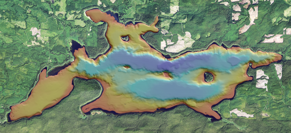
Bathymetric map of Ozette Lake in Washington State
Bathymetric map of Ozette Lake in Washington StateBathymetric map of Ozette Lake in Washington State. Cover image for the Ozette Lake Paleoseismology video.

Official websites use .gov
A .gov website belongs to an official government organization in the United States.
Secure .gov websites use HTTPS
A lock () or https:// means you’ve safely connected to the .gov website. Share sensitive information only on official, secure websites.
Bathymetric map of Ozette Lake in Washington State. Cover image for the Ozette Lake Paleoseismology video.
Bathymetric map of Ozette Lake in Washington State. Cover image for the Ozette Lake Paleoseismology video.
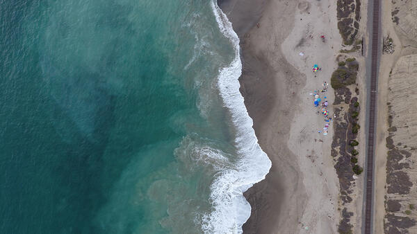
Aerial nadir view of a sandy shoreline in southern California.
Aerial nadir view of a sandy shoreline in southern California.
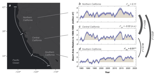
Integrated beach change for the northern, central, and southern regions of California, from the study Net widening of Southern California beaches.
Integrated beach change for the northern, central, and southern regions of California, from the study Net widening of Southern California beaches.
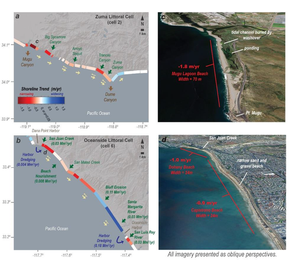
Site maps of two sections of the southern California coast with high rates of beach narrowing, from the study Net widening of Southern California beaches.
Site maps of two sections of the southern California coast with high rates of beach narrowing, from the study Net widening of Southern California beaches.
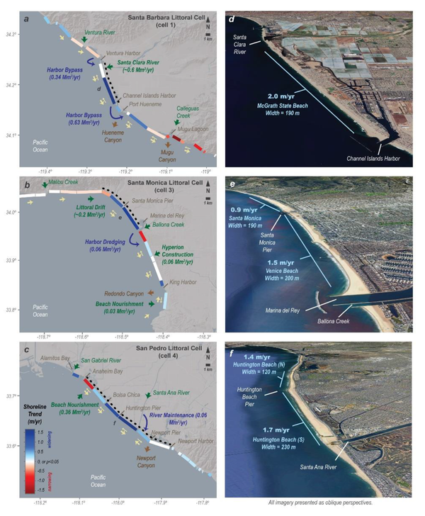
Site maps of three sections of the southern California coast with high rates of beach widening, from the study Net widening of Southern California beaches.
Site maps of three sections of the southern California coast with high rates of beach widening, from the study Net widening of Southern California beaches.
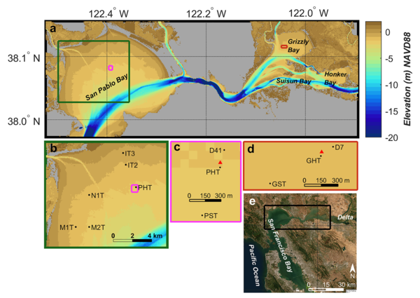
Study locations in San Pablo and Grizzly Bays, from the study Biophysical Controls on Sediment Erodibility in Shallow Estuarine Embayments.
Study locations in San Pablo and Grizzly Bays, from the study Biophysical Controls on Sediment Erodibility in Shallow Estuarine Embayments.
Ozette Lake is located above the locked portion of the northern Cascadia megathrust and is relatively isolated from other active faults.
Ozette Lake is located above the locked portion of the northern Cascadia megathrust and is relatively isolated from other active faults.
Ozette Lake is located above the locked portion of the northern Cascadia megathrust and is relatively isolated from other active faults.
Ozette Lake is located above the locked portion of the northern Cascadia megathrust and is relatively isolated from other active faults.

In Fall 2025 the Hawaiʻi Abyssal Nodules and Associated Ecosystems Expedition, led by USGS scientists, will investigate the geology, minerals, and environmental setting of the deep seabed offshore Moku o Keawe (Hawaiʻi Island) in the U.S. Exclusive Economic Zone. This work is part of ongoing collaborative efforts with BOEM and NOAA.
In Fall 2025 the Hawaiʻi Abyssal Nodules and Associated Ecosystems Expedition, led by USGS scientists, will investigate the geology, minerals, and environmental setting of the deep seabed offshore Moku o Keawe (Hawaiʻi Island) in the U.S. Exclusive Economic Zone. This work is part of ongoing collaborative efforts with BOEM and NOAA.
In Fall 2025 the Hawaiʻi Abyssal Nodules and Associated Ecosystems Expedition, led by USGS scientists, will investigate the geology, minerals, and environmental setting of the deep seabed offshore Moku o Keawe (Hawaiʻi Island) in the U.S. Exclusive Economic Zone. This work is part of ongoing collaborative efforts with BOEM and NOAA.
In Fall 2025 the Hawaiʻi Abyssal Nodules and Associated Ecosystems Expedition, led by USGS scientists, will investigate the geology, minerals, and environmental setting of the deep seabed offshore Moku o Keawe (Hawaiʻi Island) in the U.S. Exclusive Economic Zone. This work is part of ongoing collaborative efforts with BOEM and NOAA.

To conduct the science needed to understand coastal and marine geohazards, support habitat and resource management, and monitor how these environments change over time, the USGS Coastal and Marine Hazards and Resources Program relies on engineering, mechanical, and electronics expertise for field operations along the coast, in the nearshore environment, and in the d
To conduct the science needed to understand coastal and marine geohazards, support habitat and resource management, and monitor how these environments change over time, the USGS Coastal and Marine Hazards and Resources Program relies on engineering, mechanical, and electronics expertise for field operations along the coast, in the nearshore environment, and in the d
")
The global ocean is a significant carbon sink, absorbing about a third of all atmospheric carbon dioxide (CO2) emissions (Gruber et al., 2019).
The global ocean is a significant carbon sink, absorbing about a third of all atmospheric carbon dioxide (CO2) emissions (Gruber et al., 2019).
In this episode of Eyes on Earth, we begin a series on Landsat’s usefulness in coastal studies. First, we talk with Sean Vitousek, a USGS research oceanographer, about changes to beaches in California and how he is using Landsat and other data to create models that can predict how the coastline may change in the future because of sea level rise and coastal erosion.
In this episode of Eyes on Earth, we begin a series on Landsat’s usefulness in coastal studies. First, we talk with Sean Vitousek, a USGS research oceanographer, about changes to beaches in California and how he is using Landsat and other data to create models that can predict how the coastline may change in the future because of sea level rise and coastal erosion.

Two video cameras are installed atop a utility pole near the northernmost point of land in the United States at Nuvuk (Point Barrow), Alaska. The cameras point northwest toward the Arctic Ocean and the boundary between the Chukchi and Beaufort Seas. Every half hour during daylight hours, the cameras collect snapshots and video for 10 minutes.
Two video cameras are installed atop a utility pole near the northernmost point of land in the United States at Nuvuk (Point Barrow), Alaska. The cameras point northwest toward the Arctic Ocean and the boundary between the Chukchi and Beaufort Seas. Every half hour during daylight hours, the cameras collect snapshots and video for 10 minutes.

Two video cameras are installed atop a utility pole near the northernmost point of land in the United States at Nuvuk (Point Barrow), Alaska. The cameras point northwest toward the Arctic Ocean and the boundary between the Chukchi and Beaufort Seas. Every half hour during daylight hours, the cameras collect snapshots and video for 10 minutes.
Two video cameras are installed atop a utility pole near the northernmost point of land in the United States at Nuvuk (Point Barrow), Alaska. The cameras point northwest toward the Arctic Ocean and the boundary between the Chukchi and Beaufort Seas. Every half hour during daylight hours, the cameras collect snapshots and video for 10 minutes.

Two video cameras are installed atop a utility pole near the northernmost point of land in the United States at Nuvuk (Point Barrow), Alaska. The cameras point northwest toward the Arctic Ocean and the boundary between the Chukchi and Beaufort Seas. Every half hour during daylight hours, the cameras collect snapshots and video for 10 minutes.
Two video cameras are installed atop a utility pole near the northernmost point of land in the United States at Nuvuk (Point Barrow), Alaska. The cameras point northwest toward the Arctic Ocean and the boundary between the Chukchi and Beaufort Seas. Every half hour during daylight hours, the cameras collect snapshots and video for 10 minutes.

Two video cameras are installed atop a utility pole near the northernmost point of land in the United States at Nuvuk (Point Barrow), Alaska. The cameras point northwest toward the Arctic Ocean and the boundary between the Chukchi and Beaufort Seas. Every half hour during daylight hours, the cameras collect snapshots and video for 10 minutes.
Two video cameras are installed atop a utility pole near the northernmost point of land in the United States at Nuvuk (Point Barrow), Alaska. The cameras point northwest toward the Arctic Ocean and the boundary between the Chukchi and Beaufort Seas. Every half hour during daylight hours, the cameras collect snapshots and video for 10 minutes.

Two video cameras are installed atop a utility pole near the northernmost point of land in the United States at Nuvuk (Point Barrow), Alaska. The cameras point northwest toward the Arctic Ocean and the boundary between the Chukchi and Beaufort Seas. Every half hour during daylight hours, the cameras collect snapshots and video for 10 minutes.
Two video cameras are installed atop a utility pole near the northernmost point of land in the United States at Nuvuk (Point Barrow), Alaska. The cameras point northwest toward the Arctic Ocean and the boundary between the Chukchi and Beaufort Seas. Every half hour during daylight hours, the cameras collect snapshots and video for 10 minutes.

Two video cameras are installed atop a utility pole near the northernmost point of land in the United States at Nuvuk (Point Barrow), Alaska. The cameras point northwest toward the Arctic Ocean and the boundary between the Chukchi and Beaufort Seas. Every half hour during daylight hours, the cameras collect snapshots and video for 10 minutes.
Two video cameras are installed atop a utility pole near the northernmost point of land in the United States at Nuvuk (Point Barrow), Alaska. The cameras point northwest toward the Arctic Ocean and the boundary between the Chukchi and Beaufort Seas. Every half hour during daylight hours, the cameras collect snapshots and video for 10 minutes.
