Near San Simeon, view looks north up Highway 1 along the California coast toward Big Sur.
Images
Pacific Coastal and Marine Science Center images.
Near San Simeon, view looks north up Highway 1 along the California coast toward Big Sur.
Drone’s-eye views of the toe of the Mud Creek landslide
Drone’s-eye views of the toe of the Mud Creek landslideDrone’s-eye views of the toe of the Mud Creek landslide, from videos shot by Shawn Harrison on July 12, 2017
Drone’s-eye views of the toe of the Mud Creek landslide
Drone’s-eye views of the toe of the Mud Creek landslideDrone’s-eye views of the toe of the Mud Creek landslide, from videos shot by Shawn Harrison on July 12, 2017
Preliminary seafloor bathymetry collected by the USGS on July 11, 2017
Preliminary seafloor bathymetry collected by the USGS on July 11, 2017Preliminary seafloor bathymetry (shown in colors) collected by the USGS research vessel Parke Snavely on July 11, 2017. Relative depths shown in color, superimposed on a shaded-relief map from the June 26 USGS air-photo survey. Note white data gap next to the shore where water was too shallow for the Snavely to map.
Preliminary seafloor bathymetry collected by the USGS on July 11, 2017
Preliminary seafloor bathymetry collected by the USGS on July 11, 2017Preliminary seafloor bathymetry (shown in colors) collected by the USGS research vessel Parke Snavely on July 11, 2017. Relative depths shown in color, superimposed on a shaded-relief map from the June 26 USGS air-photo survey. Note white data gap next to the shore where water was too shallow for the Snavely to map.
USGS scientists continue to monitor the slide by collecting imagery every couple of weeks, weather permitting. Pilot Bob Van Wagenen, contracted through the Department of the Interior’s Office of Aviation Services, takes air photos for Jon Warrick’s Big Sur Landslide team, flying out of the Watsonville Municipal Airport in a Cessna 182R.
The Geospace Navigator bird is a streamer depth control device, used with a high-resolution seismic system to regulate and record the depth of the streamer.
Multichannel seismic-reflection profile, Sitka Sound
Multichannel seismic-reflection profile, Sitka SoundMultichannel seismic-reflection profile showing deformed and offset sediment layers below the outer continental shelf west of Sitka. The Sitka Sound fault is one of more than a dozen previously unmapped faults discovered in the July 2017 seismic-reflection data.
Multichannel seismic-reflection profile, Sitka Sound
Multichannel seismic-reflection profile, Sitka SoundMultichannel seismic-reflection profile showing deformed and offset sediment layers below the outer continental shelf west of Sitka. The Sitka Sound fault is one of more than a dozen previously unmapped faults discovered in the July 2017 seismic-reflection data.
Multichannel seismic-reflection profile, QCF fault
Multichannel seismic-reflection profile, QCF faultMultichannel seismic-reflection profile showing deformed sediment layers on the Pacific plate, just seaward of the Queen Charlotte-Fairweather fault near the south end of the study area. Location of profile shown by southern-most yellow line on trackline map, near Noyes Cyn. (Canyon).
Multichannel seismic-reflection profile, QCF fault
Multichannel seismic-reflection profile, QCF faultMultichannel seismic-reflection profile showing deformed sediment layers on the Pacific plate, just seaward of the Queen Charlotte-Fairweather fault near the south end of the study area. Location of profile shown by southern-most yellow line on trackline map, near Noyes Cyn. (Canyon).
Research vessel Ocean Starr in Alaska.
Columbia River mouth bathymetry from USGS data release
In 2017, the massive Mud Creek landslide buried a quarter-mile of the famous coastal route, California’s Highway 1, with rocks and dirt more than 65 feet deep. USGS monitors erosion along the landslide-prone cliffs of Big Sur, collecting aerial photos frequently throughout the year.
Mud Creek landslide "pyramid rock" profile and shoreface erosion
Mud Creek landslide "pyramid rock" profile and shoreface erosionIn 2017, the massive Mud Creek landslide buried a quarter-mile of the famous coastal route, California’s Highway 1, with rocks and dirt more than 65 feet deep. USGS monitors erosion along the landslide-prone cliffs of Big Sur, collecting aerial photos frequently throughout the year.
Mud Creek landslide "pyramid rock" profile and shoreface erosion
Mud Creek landslide "pyramid rock" profile and shoreface erosionIn 2017, the massive Mud Creek landslide buried a quarter-mile of the famous coastal route, California’s Highway 1, with rocks and dirt more than 65 feet deep. USGS monitors erosion along the landslide-prone cliffs of Big Sur, collecting aerial photos frequently throughout the year.
In 2017, the massive Mud Creek landslide buried a quarter-mile of the famous coastal route, California’s Highway 1, with rocks and dirt more than 65 feet deep. USGS monitors erosion along the landslide-prone cliffs of Big Sur, collecting aerial photos frequently throughout the year.
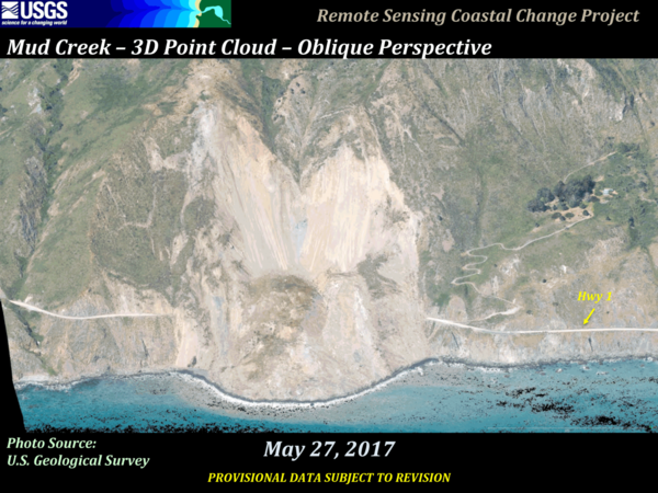
Imagery shows topographic point clouds from photos, first from September 11, 2015 courtesy of California Coastal Records Project, second from March 8, 2017 (USGS photo), third from May 19, 2017 (USGS photo), and fourth from May 27, 2017 (USGS photo) 7 days following the catastrophic Highway 1 landslide.
USGS air photo of the Mud Creek landslide, taken on May 27, 2017
USGS air photo of the Mud Creek landslide, taken on May 27, 2017USGS air photo of the Mud Creek landslide, taken on May 27, 2017
USGS air photo of the Mud Creek landslide, taken on May 27, 2017
USGS air photo of the Mud Creek landslide, taken on May 27, 2017USGS air photo of the Mud Creek landslide, taken on May 27, 2017
3D maps of air photos show views from before and after the landslide
3D maps of air photos show views from before and after the landslideTopographic “point clouds” (or 3D maps) created by computer processing of air photos show what the Mud Creek area looked like on March 8, 2017 (top), May 19 (center), and May 27 (bottom).
3D maps of air photos show views from before and after the landslide
3D maps of air photos show views from before and after the landslideTopographic “point clouds” (or 3D maps) created by computer processing of air photos show what the Mud Creek area looked like on March 8, 2017 (top), May 19 (center), and May 27 (bottom).
View from an airplane looking at the Mud Creek landslide on the Big Sur coast that occurred May 20, 2017.