
Photograph of Carmel River near the Sleepy Hollow reach. San Clemente Dam was built on Carmel River in 1921 to supply water locally. After being declared seismically unfit, plans to remove the dam began. It was completely removed in 2015.
Images
Pacific Coastal and Marine Science Center images.
Filter Total Items: 1387

Carmel River by Sleepy Hollow reach
Photograph of Carmel River near the Sleepy Hollow reach. San Clemente Dam was built on Carmel River in 1921 to supply water locally. After being declared seismically unfit, plans to remove the dam began. It was completely removed in 2015.

Seafloor mapping systems
Graphic showing geophysical and sampling systems used to define the seafloor topography, surface sediments, and underlying geology.
Graphic showing geophysical and sampling systems used to define the seafloor topography, surface sediments, and underlying geology.
The pilot and plane used to take air photos for the USGS
The pilot and plane used to take air photos for the USGSPilot Bob Van Wagenen and the Cessna 182R he flies when taking air photos for the USGS Remote Sensing Coastal Change Project.
The pilot and plane used to take air photos for the USGS
The pilot and plane used to take air photos for the USGSPilot Bob Van Wagenen and the Cessna 182R he flies when taking air photos for the USGS Remote Sensing Coastal Change Project.

Wave-driven flooding and overwash on Roi-Namur Atoll, Marshall Islands
Wave-driven flooding and overwash on Roi-Namur Atoll, Marshall IslandsPhoto shows results of wave-driven flooding and overwash on Roi-Namur Atoll, Republic of the Marshall Islands.
Wave-driven flooding and overwash on Roi-Namur Atoll, Marshall Islands
Wave-driven flooding and overwash on Roi-Namur Atoll, Marshall IslandsPhoto shows results of wave-driven flooding and overwash on Roi-Namur Atoll, Republic of the Marshall Islands.
Map showing the amount of sea-level rise that will double the chances
Map showing the amount of sea-level rise that will double the chancesMap showing the amount of sea-level rise that will double the chances of today’s “50-year floods,” which have a 2 percent chance of happening in any year. Warmer colors indicate areas at greater risk.

Orthomosaic and DEM images of Matanzas, Florida
Orthomosaic images of Matanzas, Florida, from (a) before and (b) after Hurricane Matthew, and (c) a digital elevation model (DEM) showing the associated topographic change. Note, these results were produced by applying Structure-from-Motion (SfM) to NOAA oblique photographs, but similar results can be obtained using UAS aerial imagery.
Orthomosaic images of Matanzas, Florida, from (a) before and (b) after Hurricane Matthew, and (c) a digital elevation model (DEM) showing the associated topographic change. Note, these results were produced by applying Structure-from-Motion (SfM) to NOAA oblique photographs, but similar results can be obtained using UAS aerial imagery.

Exposed bedrock on California beach during very low tide
Exposed bedrock on California beach during very low tideExposed bedrock on the beach during very low (negative) tide at Isla Vista, California
Exposed bedrock on California beach during very low tide
Exposed bedrock on California beach during very low tideExposed bedrock on the beach during very low (negative) tide at Isla Vista, California

Perspective views of multibeam bathymetry data acquired by the USGS
Perspective views of multibeam bathymetry data acquired by the USGSPerspective views of multibeam bathymetry data acquired by the USGS aboard the R/V Medeia. Shallower depths in red. Arrows point to the distinct line in the seafloor associated with the Queen Charlotte-Fairweather fault.

PCMSC Marine Minerals Laboratory
A look into the USGS Pacific Coastal and Marine Science Center’s Marine Minerals Laboratory Suite.
A look into the USGS Pacific Coastal and Marine Science Center’s Marine Minerals Laboratory Suite.

Necker Ridge ferromanganese crust
Top of a ferromanganese crust sample collected from 1,896 meters water depth at Necker Ridge in the central north Pacific. The surface of this crust was in contact with ocean water and grew just 2 millimeters per million years.
Top of a ferromanganese crust sample collected from 1,896 meters water depth at Necker Ridge in the central north Pacific. The surface of this crust was in contact with ocean water and grew just 2 millimeters per million years.

Talking about seafloor mineral deposits
Research geologist Jim Hein (right) gave a hands-on explanation of seafloor mineral deposits.
Research geologist Jim Hein (right) gave a hands-on explanation of seafloor mineral deposits.

Sifting sand with sieves
During a USGS Open House in Santa Cruz, California, research geologist Amy East shows onlookers how to sift sand to determine its size.
During a USGS Open House in Santa Cruz, California, research geologist Amy East shows onlookers how to sift sand to determine its size.

USGS Open House discussions
Members of the PCMSC Marine Minerals Team, including physical science technician Kira Mizell (center), took turns describing the importance of seafloor minerals.
Members of the PCMSC Marine Minerals Team, including physical science technician Kira Mizell (center), took turns describing the importance of seafloor minerals.

Sharing information on the screen
Visitors watched closely as Alicia Balster-Gee (in green vest) presented our research on marine geohazards in Alaska.
Visitors watched closely as Alicia Balster-Gee (in green vest) presented our research on marine geohazards in Alaska.

Upper terrace of Mud Creek slide
Mud Creek slide from south side of north upper terrace (above north and south berms). Note tension cracks and offset on the terrace to the north.
Mud Creek slide from south side of north upper terrace (above north and south berms). Note tension cracks and offset on the terrace to the north.

Field survey methods
Photos of survey equipment used during surveys of the Elwha River delta, Washington, from 2010-2017, showing:
Photos of survey equipment used during surveys of the Elwha River delta, Washington, from 2010-2017, showing:

Flooding on a road in Olympic National Park, Washington
Flooding on a road in Olympic National Park, WashingtonFlooding on a road in Olympic National Park, Washington, on November 24, 2017.
Flooding on a road in Olympic National Park, Washington
Flooding on a road in Olympic National Park, WashingtonFlooding on a road in Olympic National Park, Washington, on November 24, 2017.

Santa Cruz Main Beach Webcam Snapshot
Snapshot from video camera that sits atop the Dream Inn looks eastward over Main Beach and boardwalk in Santa Cruz, California.
Snapshot from video camera that sits atop the Dream Inn looks eastward over Main Beach and boardwalk in Santa Cruz, California.

Santa Cruz Main Beach
Still-image from video camera atop the Dream Inn looks eastward over Main Beach and boardwalk in Santa Cruz, CA.
Still-image from video camera atop the Dream Inn looks eastward over Main Beach and boardwalk in Santa Cruz, CA.
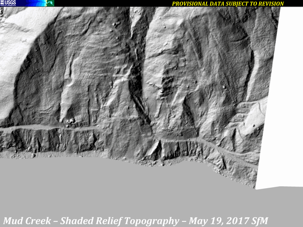
Mud Creek Shaded-Relief Topography, 2010-2017
A series of images from various sources of shaded-relief topography show the progression of the Mud Creek landslide area, from 2010 through October 12, 2017.
Sources:
A series of images from various sources of shaded-relief topography show the progression of the Mud Creek landslide area, from 2010 through October 12, 2017.
Sources:
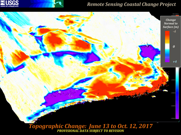
Mud Creek Topo Change June 13-October 12 2017 View 3
Mud Creek Topo Change June 13-October 12 2017 View 3In 2017, the massive Mud Creek landslide buried a quarter-mile of the famous coastal route, California’s Highway 1, with rocks and dirt more than 65 feet deep. USGS monitors erosion along the landslide-prone cliffs of Big Sur, collecting aerial photos frequently throughout the year.