
Floods, Droughts, and Hurricanes
Floods, Droughts, and Hurricanes
South Atlantic Water Science Center Flood Resources
USGS tools, websites, publications and other resources for monitoring, studying and communicating flood information.
USGS tools, websites, publications and other resources for monitoring, studying and communicating flood information.
South Atlantic Water Science Center Drought Resources
USGS tools, websites, publications, and other resources for monitoring, studying, and communicating drought information.
USGS tools, websites, publications, and other resources for monitoring, studying, and communicating drought information.
Hurricanes
USGS tools, websites, publications, and other resources for monitoring, studying, and communicating hurricane information.
USGS tools, websites, publications, and other resources for monitoring, studying, and communicating hurricane information.
Flood, Drought and Hurricanes
Information Links
Information Links
Filter Total Items: 25
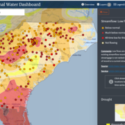
South Atlantic Water Science Center Drought Monitoring
When rainfall is less than normal for several weeks, months, or years, the flow of streams and rivers declines, water levels in lakes and reservoirs fall, and the depth to water in wells increases. If dry weather persists and water-supply problems develop, the dry period can become a drought.

Floods and the South Atlantic Water Science Center
Georgia, North Carolina and South Carolina flood related information.

Flood-inundation mapping in Tar River Basin, North Carolina
The U.S. Geological Survey (USGS) has created flood-inundation maps for selected streamgage sites in North Carolina. These maps depict the approximate area that would be inundated at selected water levels, ranging from approximately top-of-bank to the maximum observed water level. The inundated areas depicted on these maps are approximate, and accuracy of the maps is a function of the accuracy of...

Hurricane Monitoring Information for Georgia, North Carolina, and South Carolina
Hurricane Information for Georgia, North Carolina, and South Carolina.

Computation of low-flow statistics at continuous-record streamgages and regionalization of selected low-flow characteristics for streams in Georgia, South Carolina, and North Carolina
This ongoing USGS study for Georgia, South Carolina, and North Carolina aims to (1) compute low-flow statistics at selected continuous-record streamgages in Georgia, South Carolina, and North Carolina and to (2) develop regional regression equations for a subset of those low-flow characteristics for streams that are not substantially affected by tides, regulation, diversions, or other...
Low-Flow Frequency and Flow Duration Statistics at Continuous-Record Gages in South Carolina
South Carolina State agencies use low-flow statistics for many applications, including determining waste-load allocations for point sources, development of total maximum daily loads (TMDLs) for streams, determining the quantity of water that can be safely withdrawn from a particular stream, and preparing the State Water Plan. This project will monitor the low-flow frequency and duration statistics...

The 1977 Toccoa Flood, Report of Failure of Kelly Barnes Dam Flood and Findings
The Kelly Barnes Dam, located above the Toccoa Falls Bible College near Toccoa, Georgia, failed in the early morning hours of November 6, 1977. Thirty-nine people died in the resulting flood, which inundated part of the campus including a trailer park. These Web pages make available two historical reports on the flood and an album of photos of the disaster.

South Atlantic Water Science Center Storm-Tide Monitoring
Preventing flood hazards, such as the hurricane induced storm surge, from becoming human disasters requires an understanding of the relative risks floods pose to specific communities and knowledge of the processes by which flood waters rise, converge, and abate. Historically, hurricane-induced storm tides have been documented through measurement of high-water marks left on structures or vegetation...

Flood-Inundation mapping in Georgia, North and South Carolina
The U.S. Geological Survey (USGS) has created flood-inundation maps for selected streamgage sites in Georgia, North and South Carolina. These maps depict the approximate area that would be inundated at selected water levels, ranging from approximately top-of-bank to the maximum observed water level. The inundated areas depicted on these maps are approximate, and accuracy of the maps is a function...

Real-Time Precipitation at Sites in Georgia, North and South Carolina
We now have a map and data table-based system to allow you to view real-time precipitation at Georgia, North and South Carolina water-monitoring sites. The rainfall maps and tables are updated continuously and display data from the last 1-3,6,12,24 hours and 2 and 7 days.

Effects of Impoundments on Selected Streamflow Characteristics
The objective of this investigation will be to assess the effects of impoundments on streamflow across the contiguous hydrologic regions in South Carolina, North Carolina, and Georgia as defined by Feaster and others (2014, 2009). Given the historic flooding in South Carolina in October 2015 following Hurricane Joaquin (Feaster and others, 2015) and in South Carolina and North Carolina in October...

Techniques for Estimating Magnitude and Frequency of Floods for Rural Basins in the Southeastern United States
Reliable estimates of the magnitude and frequency of floods are part of the technically-based framework for hydraulic-structure design and flood-plain delineation in South Carolina, North Carolina, and Georgia. Annual peak flows measured at U.S. Geological Survey (USGS) streamflow gaging stations (stations) are used to compute flood frequency estimates for a location on a stream. However, such...