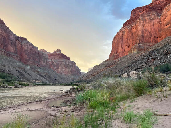
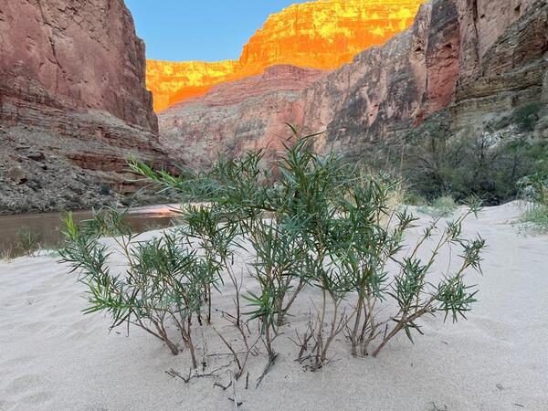
U.S. flag

An official website of the United States government

Images

Below are images associated with SBSC's science and staff. Images appear according to the year they were taken. To search, type a keyword or select a year from the dropdown menu. Or, click through the pages using the arrows at the bottom of the page. 

Filter Total Items: 641
Nick Voichick at the winch, Lake Powell water quality monitoring
Nick Voichick at the winch on Lake Powell during water quality monitoring

SBSC monitors Lake Powell water quality in partnership with the Bureau of Reclamation Colorado River Salinity Control Program and the National Park Service Glen Canyon National Recreation Area. Photo by SBSC, Grand Canyon Monitoring and Research Center, March 2022.

SBSC monitors Lake Powell water quality in partnership with the Bureau of Reclamation Colorado River Salinity Control Program and the National Park Service Glen Canyon National Recreation Area. Photo by SBSC, Grand Canyon Monitoring and Research Center, March 2022.

Women monitors a site in the Sonoran Desert
RestoreNet Monitor
RestoreNet Monitor
RestoreNet Monitor

Starting in 2017, U.S. Geological Survey (USGS) researchers and land managers are co-producing a network of restoration field trial sites on Department of Interior (DOI) and surrounding lands in the southwestern U.S. The network systematically tests restoration treatments across a broad range of landscape, soil, and climate conditions.

Starting in 2017, U.S. Geological Survey (USGS) researchers and land managers are co-producing a network of restoration field trial sites on Department of Interior (DOI) and surrounding lands in the southwestern U.S. The network systematically tests restoration treatments across a broad range of landscape, soil, and climate conditions.

Glen Canyon Dam forebay

The forebay of Glen Canyon Dam. Photo taken from the Glen Canyon tailwater by SBSC, March 2022.

The forebay of Glen Canyon Dam. Photo taken from the Glen Canyon tailwater by SBSC, March 2022.

Lake Powell, Escalante River arm

Camping on the banks of the Escalante River arm of Lake Powell. Image by SBSC, March 2022.

Camping on the banks of the Escalante River arm of Lake Powell. Image by SBSC, March 2022.

Lake Powell panorama
Lake Powell panorama, taken during water quality monitoring trip in March 2022

Lake Powell panorama, taken during SBSC's March 2022 quarterly water quality monitoring trip. The image was taken as USGS staff were about to set up camp for the night. Notice the lower lake levels.

Soaking up stormwater infographic

Infographic summarizing the main lessons learned from a USGS study in Clarksburg, Maryland assessing the impacts of distributed stormwater management on stream health.

Infographic summarizing the main lessons learned from a USGS study in Clarksburg, Maryland assessing the impacts of distributed stormwater management on stream health.

SBSC's Bridget Deemer labeling samples during a Lake Powell water quality monitoring trip
Bridget Deemer labeling samples during a Lake Powell water quality monitoring trip

Bridget Deemer labeling samples during a Lake Powell water quality monitoring trip. Photo by SBSC, Grand Canyon Monitoring and Research Center.

Lake Powell water quality sampling

Nick Voichick and Bridget Deemer from SBSC are conducting water quality sampling on Lake Powell. Photo by SBSC, March 2022.

Nick Voichick and Bridget Deemer from SBSC are conducting water quality sampling on Lake Powell. Photo by SBSC, March 2022.

A composite of 4 photos of Joshua trees and researchers conducting fieldwork
Joshua tree research - a composite of 4 photos taken during fieldwork

A composite of four photos taken during research on Joshua trees, Arizona Joshua Tree Forest, Mojave Desert. Photos by Morgan Andrews and Daniel Winkler, USGS, SBSC. Daniel Winkler is pictured at top right, and Morgan Andrews is pictured at bottom left.

A composite of four photos taken during research on Joshua trees, Arizona Joshua Tree Forest, Mojave Desert. Photos by Morgan Andrews and Daniel Winkler, USGS, SBSC. Daniel Winkler is pictured at top right, and Morgan Andrews is pictured at bottom left.

A photo of a stream gage above Moenkopi Wash, near Cameron, AZ
Moenkopi Wash stream gage near Cameron, AZ, in 2022

Stream gage # 09401500 on Moenkopi Wash near Cameron, Arizona. Photo by David Dean, USGS, SBSC. This image is a repeat photograph of one taken in 1959 at the same location.

Stream gage # 09401500 on Moenkopi Wash near Cameron, Arizona. Photo by David Dean, USGS, SBSC. This image is a repeat photograph of one taken in 1959 at the same location.

USGS and USFWS remote sensing at Eagle Tank water catchment in Cabeza Prieta National Wildlife Refuge
Remote sensing at Eagle Tank water catchment ("tinaja") in Cabeza Prieta National Wildlife Refuge

USGS remote sensing at Eagle Tank water catchment ("tinaja") in Cabeza Prieta National Wildlife Refuge, southern Arizona, in collaboration with US Fish and Wildlife Service. Photo by Josh Caster, USGS.

USGS and USFWS surveyors conducting research at Eagle Tank water catchment in Cabeza Prieta National Wildlife Refuge
Remote sensing at Eagle Tank water catchment ("tinaja") in Cabeza Prieta National Wildlife Refuge

Remote sensing of the Eagle Tank water catchment ("tinaja") in Cabeza Prieta National Wildlife Refuge, southern Arizona, by USGS in collaboration with US Fish and Wildlife Service. Photo by Steven Sesnie, USFWS.

A mountain range above low desert in southern Arizona's Cabeza Prieta National Wildlife Refuge
A mountain range in Cabeza Prieta National Wildlife Refuge, AZ

A mountain range in Cabeza Prieta National Wildlife Refuge, southern Arizona. This location is half a mile from the tinaja called Eagle Tank. 

USGS and USFWS personnel stand in a line for a photo in the Cabeza Prieta National Wildlife Refuge desert, AZ
USGS and USFWS personnel in the Cabeza Prieta National Wildlife Refuge desert, AZ

A team of USGS and US Fish and Wildlife personnel who worked on remote sensing of water catchments called "tinajas" in Cabeza Prieta National Wildlife Refuge in order to assess their water storage.

An expanse of low desert with shrubs and mountains in the distance in Cabeza Prieta National Wildlife Refuge
Cabeza Prieta National Wildlife Refuge near Tule Well

Cabeza Prieta National Wildlife Refuge low desert near Tule Well, between Senita and Buckhorn Tanks, with mountains in the distance. Photo by Josh Caster, USGS.

Cabeza Prieta National Wildlife Refuge low desert near Tule Well, between Senita and Buckhorn Tanks, with mountains in the distance. Photo by Josh Caster, USGS.

Low desert with shrubs, ocotillos, saguaros and mountains in the distance at Cabeza Prieta National Wildlife Refuge
Cabeza Prieta National Wildlife Refuge on the way to Eagle Tank

Cabeza Prieta National Wildlife Refuge desert with ocotillos and saguaros and mountains in the distance, on the way to Eagle Tank, a tinaja or water catchment in bedrock used by desert bighorn sheep. Photo by Josh Caster, USGS.

Cabeza Prieta National Wildlife Refuge desert with ocotillos and saguaros and mountains in the distance, on the way to Eagle Tank, a tinaja or water catchment in bedrock used by desert bighorn sheep. Photo by Josh Caster, USGS.

Cabeza Prieta National Wildlife Refuge, looking out on a valley below with a survey tripod in the foreground.
A survey tripod in Cabeza Prieta National Wildlife Refuge

A survey tripod above Eagle Tank looking out over a valley in Cabeza Prieta National Wildlife Refuge, southern Arizona. Photo by Josh Caster, USGS.
 

A survey tripod above Eagle Tank looking out over a valley in Cabeza Prieta National Wildlife Refuge, southern Arizona. Photo by Josh Caster, USGS.
 

A rock outcropping with a survey tripod on top of it, looking out over the low desert in Cabeza Prieta NWR
Surveying at Senita Tank in the Cabeza Prieta National Wildlife Refuge

A survey tripod on top of a rock outcropping at Senita Tank, a water catchment or tinaja in the Cabeza Prieta National Wildlife Refuge in southern Arizona. Desert bighorn sheep rely on these water catchments, especially during summer months. Photo by Josh Caster, USGS.

A survey tripod on top of a rock outcropping at Senita Tank, a water catchment or tinaja in the Cabeza Prieta National Wildlife Refuge in southern Arizona. Desert bighorn sheep rely on these water catchments, especially during summer months. Photo by Josh Caster, USGS.

A person walks near a remote sensing station at a water catchment in Cabeza Prieta National Wildlife Refuge
Remote sensing at the Buckhorn Tank water catchment in Cabeza Prieta National Wildlife Refuge

Remote sensing at the Buckhorn Tank water catchment (also called a "tinaja") used by desert bighorn sheep in Cabeza Prieta National Wildlife Refuge, southern Arizona. Photo by Joel Sankey, USGS.

USGS surveyors outside of a water catchment in Cabeza Prieta National Wildlife Refuge, AZ
Surveying the Buckhorn Tank water catchment ("tinaja") in Cabeza Prieta National Wildlife Refuge, AZ

USGS in collaboration with US Fish and Wildlife Service surveys the Buckhorn Tank water catchment ("tinaja") in Cabeza Prieta National Wildlife Refuge, southern Arizona. Photo by Josh Caster, USGS.

The USFWS sign that says Cabeza Prieta National Wildlife Refuge at the entry to the Refuge, in the Sonoran Desert
The sign at the entry to USFWS Cabeza Prieta National Wildlife Refuge

The sign at the entry to the US Fish and Wildlife Service Cabeza Prieta National Wildlife Refuge. The Refuge is in the Sonoran Desert on the Arizona and Mexico border, and much of it is designated wilderness area.

The sign at the entry to the US Fish and Wildlife Service Cabeza Prieta National Wildlife Refuge. The Refuge is in the Sonoran Desert on the Arizona and Mexico border, and much of it is designated wilderness area.

Was this page helpful?