
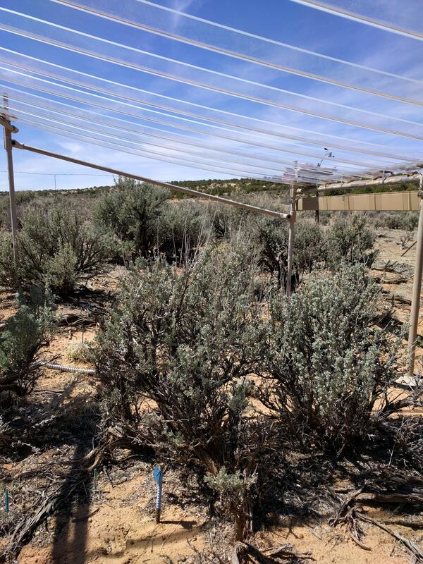
The RestoreNet gardens test seedlings of priority restoration species across the Southwest. This is a recently installed garden located in the juniper woodlands of the Colorado Plateau. The experiemental network will support land managers by providing insight into various restoration techniques, including testing seedlings vs seeds.
Images
Below are images associated with SBSC's science and staff. Images appear according to the year they were taken. To search, type a keyword or select a year from the dropdown menu. Or, click through the pages using the arrows at the bottom of the page.
Filter Total Items: 703

RestoreNet garden testing seedling establishment.
The RestoreNet gardens test seedlings of priority restoration species across the Southwest. This is a recently installed garden located in the juniper woodlands of the Colorado Plateau. The experiemental network will support land managers by providing insight into various restoration techniques, including testing seedlings vs seeds.

Biocrust survey, Utah
Biocrust survey, Colorado Plateau, Utah, with SBSC staff. Photo courtesy of Erika Geiger, USGS, 2018.
Biocrust survey, Colorado Plateau, Utah, with SBSC staff. Photo courtesy of Erika Geiger, USGS, 2018.

A perennial native warm season grass, Sporobolus cryptandrus (sand dropseed), at a study site
A perennial native warm season grass, Sporobolus cryptandrus (sand dropseed), at a study siteA perennial native warm season grass, Sporobolus cryptandrus (sand dropseed), at a long-term study site that looks at the effects of drought on vegetation and soils in the Utah drylands on the Colorado Plateau.

RestoreNet outplanted seedlings (left) v. direct seeding with soil surface treatments (right)
RestoreNet outplanted seedlings (left) v. direct seeding with soil surface treatments (right)Left: RestoreNet outplant trials with greenhouse-grown seedlings planted into the field, Right: RestoreNet direct seeding trials with seeds combined with soil surface modifications including ConMod artificial nurse plants, mulch, and soil pits. Photos by Katie Laushman (USGS).

Collaborating with university students
The Southwest Biological Science Center loves working with students. Here, a group of undergraduates from Northern Arizona University help RAMPS define the reasons why ecosystem restoration is important for human health and the economy. Follow the link to learn more about RAMPS.
The Southwest Biological Science Center loves working with students. Here, a group of undergraduates from Northern Arizona University help RAMPS define the reasons why ecosystem restoration is important for human health and the economy. Follow the link to learn more about RAMPS.
Rainout shelters allow researchers to study the effects of drought
Rainout shelters allow researchers to study the effects of droughtThis rainout shelter blcoks about 35% of the natural rainfall, allowing researchers to understand the effects of drought on plants in the southwestern United States.
Rainout shelters allow researchers to study the effects of drought
Rainout shelters allow researchers to study the effects of droughtThis rainout shelter blcoks about 35% of the natural rainfall, allowing researchers to understand the effects of drought on plants in the southwestern United States.

Rainout shelters allow researchers to study effects of drought
Rainout shelters allow researchers to study effects of droughtRainout shelters block about 35% of natural rainfall, allowing researchers to study the effects of drought on plants in the arid and semiarid southwestern United States.
Rainout shelters allow researchers to study effects of drought
Rainout shelters allow researchers to study effects of droughtRainout shelters block about 35% of natural rainfall, allowing researchers to study the effects of drought on plants in the arid and semiarid southwestern United States.
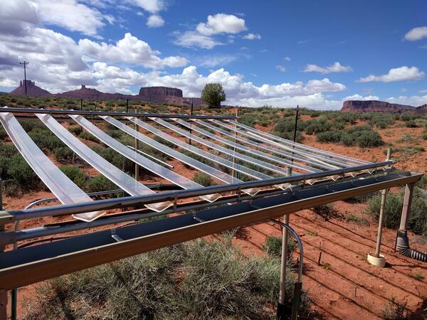
Rainout structures allow researchers to study the effects of drought
Rainout structures allow researchers to study the effects of droughtThis rainout structure blocks about 35% of the natural rainfall, allowing researchers to study the effects of drought on plants in the southwestern United States.
Rainout structures allow researchers to study the effects of drought
Rainout structures allow researchers to study the effects of droughtThis rainout structure blocks about 35% of the natural rainfall, allowing researchers to study the effects of drought on plants in the southwestern United States.

Red Brome Carries Fire and Burns Saguaros
Bromus Rubens (red brome) is an invasive annual grass that grows in warmer deserts of the Southwest U.S. It can carry fires in systems that aren't fire adapted, causing lasting damage to desert flora, as shown here in the Sonoran desert north of Phoenix, AZ.
Bromus Rubens (red brome) is an invasive annual grass that grows in warmer deserts of the Southwest U.S. It can carry fires in systems that aren't fire adapted, causing lasting damage to desert flora, as shown here in the Sonoran desert north of Phoenix, AZ.

Restoration happens one seed at a time
In water-limited systems of the desert Southwest, land managers sometimes restore using seedlings (small plants) instead of seeds alone. This method has shown to be successful in extreme environments like the Mojave desert and also in grasslands where weed pressure can be to high for seeds to germinate and survive.
In water-limited systems of the desert Southwest, land managers sometimes restore using seedlings (small plants) instead of seeds alone. This method has shown to be successful in extreme environments like the Mojave desert and also in grasslands where weed pressure can be to high for seeds to germinate and survive.

Investing in future biological science leaders
RAMPS works with a restoration club at Northern Arizona University, teaching best practices for restoration, and building capacity for future scientisits and land managers to tackle challenging ecological issues.
RAMPS works with a restoration club at Northern Arizona University, teaching best practices for restoration, and building capacity for future scientisits and land managers to tackle challenging ecological issues.

Juniper Skeletons
Thinning rangelands by removing trees such as juniper is a common mangement action done across the intermountain west. The goals of this type of vegetation treatment typically are to increase forage and habitat for grazing animals, improve soil conditions, and/or reduce risks of catastrophic fire.
Thinning rangelands by removing trees such as juniper is a common mangement action done across the intermountain west. The goals of this type of vegetation treatment typically are to increase forage and habitat for grazing animals, improve soil conditions, and/or reduce risks of catastrophic fire.

Standing in the field with managers
Touring public lands, guided by the people who manage the lands, is a important to RAMPS. On these tours we get to meet the passionate people, understand their challenges and aspirations, and help make steps towards innovative science-based solutions.
Touring public lands, guided by the people who manage the lands, is a important to RAMPS. On these tours we get to meet the passionate people, understand their challenges and aspirations, and help make steps towards innovative science-based solutions.

Standing in the field with public land managers
RAMPS works with public land managers to better understand the challenges they face, so that the decision frameworks and tools they create are relevant. Learn more at RAMPS.
RAMPS works with public land managers to better understand the challenges they face, so that the decision frameworks and tools they create are relevant. Learn more at RAMPS.

Biocrusts, Utah
Dark biocrusts. Photo taken by SBSC in Utah during surveys, 2018, courtesy of Erika Geiger.
Dark biocrusts. Photo taken by SBSC in Utah during surveys, 2018, courtesy of Erika Geiger.

Organ Pipe Cactus National Monument
Organ pipe cactus are rare in the Sonoran desert in the U.S. They can only be found in and around Organ Pipe Cactus National Monument, shown here. The distribution of Organ Pipe Cactus is limited due to lack of tolerance for cold temperatures. The biota of the Sonoran desert is particularly senstive to disturbance.
Organ pipe cactus are rare in the Sonoran desert in the U.S. They can only be found in and around Organ Pipe Cactus National Monument, shown here. The distribution of Organ Pipe Cactus is limited due to lack of tolerance for cold temperatures. The biota of the Sonoran desert is particularly senstive to disturbance.

Flowering and fruiting saguaro, Saguaro National Park
Flowering and fruiting saguaro, Saguaro National ParkSaguaro cacti flower and produce fruit in the spring in Tucson, Saguaro National Park, southern Arizona. Photo by Daniel Winkler, SBSC, USGS.
Flowering and fruiting saguaro, Saguaro National Park
Flowering and fruiting saguaro, Saguaro National ParkSaguaro cacti flower and produce fruit in the spring in Tucson, Saguaro National Park, southern Arizona. Photo by Daniel Winkler, SBSC, USGS.

Biocrust damage from vehicle
Biocrusts damaged by vehicle. Photo taken by SBSC during surveys, Utah, courtesy of Erika Geiger, 2018.
Biocrusts damaged by vehicle. Photo taken by SBSC during surveys, Utah, courtesy of Erika Geiger, 2018.
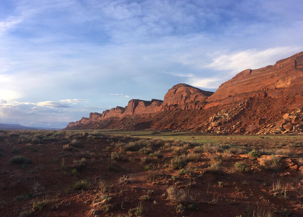
Comb Ridge, Utah
Comb Ridge in southeastern Utah. Photo courtesy of Rob Massatti, USGS, Southwest Biological Science Center, taken in 2017.
Comb Ridge in southeastern Utah. Photo courtesy of Rob Massatti, USGS, Southwest Biological Science Center, taken in 2017.

Dry, cracked soil (RAMPS)
Rangelands of the desert Southwest can be in a degraded condition and lacking perennial vegetation, which can lead to exposed soil and erosion.
Rangelands of the desert Southwest can be in a degraded condition and lacking perennial vegetation, which can lead to exposed soil and erosion.

Collaborative Discussion
The USGS RAMPS program hosts workshops where land managers from federal, state, and local agencies, practitioners, and NGO's can come together to discuss challenges and develop creative solutions.
The USGS RAMPS program hosts workshops where land managers from federal, state, and local agencies, practitioners, and NGO's can come together to discuss challenges and develop creative solutions.