Field technicians taking root data on dryland plant species for EDGE
Field technicians taking root data on dryland plant species for EDGEField technicians taking root data on dryland plant species on the Colorado Plateau.


Official websites use .gov
A .gov website belongs to an official government organization in the United States.

Secure .gov websites use HTTPS
A lock () or https:// means you’ve safely connected to the .gov website. Share sensitive information only on official, secure websites.

Below are images associated with SBSC's science and staff. Images appear according to the year they were taken. To search, type a keyword or select a year from the dropdown menu. Or, click through the pages using the arrows at the bottom of the page.
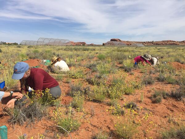
Field technicians taking root data on dryland plant species on the Colorado Plateau.
Field technicians taking root data on dryland plant species on the Colorado Plateau.

A Kelp Crab (Pugettia producta) captured in a beach seine during a 2012 Bainbridge Island larval forage fish survey. This survey focused on the abundance, habitat use, and food habits of larval forage fish (surf smelt and sand lance) and was conducted by scientists from the Columbia River Research Laboratory -Western Fisheries Research Center.
A Kelp Crab (Pugettia producta) captured in a beach seine during a 2012 Bainbridge Island larval forage fish survey. This survey focused on the abundance, habitat use, and food habits of larval forage fish (surf smelt and sand lance) and was conducted by scientists from the Columbia River Research Laboratory -Western Fisheries Research Center.

Ecosystems are changing at a rapid pace. It can be difficult to determine if a landscape is in need of restoration. In this photo of the spring wildflower bloom in the Sonoran desert, an invasive annual grass, Bromus rubens (red brome), is pervasive. Land managers have to make decisions about when, where, and how to intervene in a system.
Ecosystems are changing at a rapid pace. It can be difficult to determine if a landscape is in need of restoration. In this photo of the spring wildflower bloom in the Sonoran desert, an invasive annual grass, Bromus rubens (red brome), is pervasive. Land managers have to make decisions about when, where, and how to intervene in a system.

Snow-capped peaks of the La Sal Mountain Range as seen from the Island in the Sky District of Canyonlands National Park. This is one area in the Southwest where biocrust plays an important role.
Snow-capped peaks of the La Sal Mountain Range as seen from the Island in the Sky District of Canyonlands National Park. This is one area in the Southwest where biocrust plays an important role.
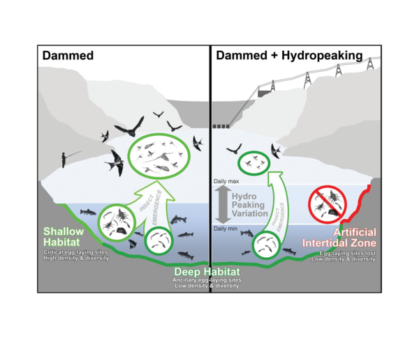
Hydropeaking creates a bottleneck for aquatic insects. Insect eggs laid along a rivers edge become dessicated when exposed to the air during low flows. Figure originally published in Bioscience; Kennedy et al. 2016.
Hydropeaking creates a bottleneck for aquatic insects. Insect eggs laid along a rivers edge become dessicated when exposed to the air during low flows. Figure originally published in Bioscience; Kennedy et al. 2016.

During the fall bats can be seen emerging from under the causeway at Yolo Bypass Wildlife Area near Sacramento, CA. Photo by Erika Sanchez-Chopitea, Western Geographic Science Center, USGS.
During the fall bats can be seen emerging from under the causeway at Yolo Bypass Wildlife Area near Sacramento, CA. Photo by Erika Sanchez-Chopitea, Western Geographic Science Center, USGS.

Aerial view showing the intense greenup of restoration plots in the lower Colorado River Delta following the 2014 Minute 319 pulse flow.
Aerial view showing the intense greenup of restoration plots in the lower Colorado River Delta following the 2014 Minute 319 pulse flow.

Salt-encrusted remains of a southwestern pond turtle (Actinemys pallida) as found in the dry lake bed of Elizabeth Lake, Los Angeles County, California. Note the heavy coating of evaporites on the carcass. Most living turtles collected in 2014 had similar but varying degrees of coatings on the head, limbs and shell.
Salt-encrusted remains of a southwestern pond turtle (Actinemys pallida) as found in the dry lake bed of Elizabeth Lake, Los Angeles County, California. Note the heavy coating of evaporites on the carcass. Most living turtles collected in 2014 had similar but varying degrees of coatings on the head, limbs and shell.

Photograph of Elizabeth Lake in the fourth year of drought and two years after the Powerhouse Fire. Note salt encrustation of surface and small accumulations of water remaining in the foreground and background.
Almost all of the turtles living in a southern California lake died following a large fire and years of drought, according to a new USGS report.
Photograph of Elizabeth Lake in the fourth year of drought and two years after the Powerhouse Fire. Note salt encrustation of surface and small accumulations of water remaining in the foreground and background.
Almost all of the turtles living in a southern California lake died following a large fire and years of drought, according to a new USGS report.

A block print of a Myotis bat species by Kate Aitchison, done through a RISD/USGS internship with the Southwest Biological Science Center, 2015.
A block print of a Myotis bat species by Kate Aitchison, done through a RISD/USGS internship with the Southwest Biological Science Center, 2015.

USGS scientist Jessica Mikenas collects surface soil pH data on decommissioned well pad.
USGS scientist Jessica Mikenas collects surface soil pH data on decommissioned well pad.

USGS soil scientist Travis Nauman records vegetation data on decommissioned well pad.
USGS soil scientist Travis Nauman records vegetation data on decommissioned well pad.

USGS soil scientist Travis Nauman records vegetation data on decommissioned well pad.
USGS soil scientist Travis Nauman records vegetation data on decommissioned well pad.

USGS soil scientist Travis Nauman examines biological soil crust communities near an abandoned well pad during field work.
USGS soil scientist Travis Nauman examines biological soil crust communities near an abandoned well pad during field work.

Moenkopi Wash, stream gage # 09401400 near Tuba City, AZ. This photo, taken in 2015, is a match to a historic image taken in 1941 of a man on a bridge at the same location. This photo shows extensive vegetation encroachment and channel narrowing of Moenkopi Wash. Photo by David Dean, USGS, SBSC.
Moenkopi Wash, stream gage # 09401400 near Tuba City, AZ. This photo, taken in 2015, is a match to a historic image taken in 1941 of a man on a bridge at the same location. This photo shows extensive vegetation encroachment and channel narrowing of Moenkopi Wash. Photo by David Dean, USGS, SBSC.

A type of aquatic insect called a stonefly (family Perlidae), in its larval stage, from the Green River just downstream of Fontenelle Dam, near Kemmerer, Wyoming (May 10, 2015).
A type of aquatic insect called a stonefly (family Perlidae), in its larval stage, from the Green River just downstream of Fontenelle Dam, near Kemmerer, Wyoming (May 10, 2015).

Sampling invertebrates downstream of Flaming Gorge Dam, on the Green River near Dutch John, Utah, May 8, 2015.
Sampling invertebrates downstream of Flaming Gorge Dam, on the Green River near Dutch John, Utah, May 8, 2015.

In drylands, short-term extreme droughts can have profound ecosystem effects. In this study, we are examining the impacts of extreme seasonal drought on grassland communities of the Colorado Plateau & recovery from drought.
In drylands, short-term extreme droughts can have profound ecosystem effects. In this study, we are examining the impacts of extreme seasonal drought on grassland communities of the Colorado Plateau & recovery from drought.

This repeat photograph is a match to a historic image taken in 1965 in Canyonlands National Park, on Salt Creek just upstream from Peekaboo Arch.
This repeat photograph is a match to a historic image taken in 1965 in Canyonlands National Park, on Salt Creek just upstream from Peekaboo Arch.

Moenkopi Wash, looking upstream, stream gage # 09401400 near Tuba City, AZ. This photo, taken in 2015, is a match to a historic image taken in 1941 taken in the same location. This photo shows extensive vegetation encroachment and channel narrowing of Moenkopi Wash. Photo by David Dean, USGS, SBSC.
Moenkopi Wash, looking upstream, stream gage # 09401400 near Tuba City, AZ. This photo, taken in 2015, is a match to a historic image taken in 1941 taken in the same location. This photo shows extensive vegetation encroachment and channel narrowing of Moenkopi Wash. Photo by David Dean, USGS, SBSC.

People relax on a raft floating through a calm section of the Colorado River in Grand Canyon
People relax on a raft floating through a calm section of the Colorado River in Grand Canyon