



How Storm-Impact Regimes Affect Beach Complexes: Coastal Hazards
This webpage explains coastal hazards caused by high water at the coast. These high-water levels, called "total water levels," happen when tides, waves, and storms combine and push the ocean higher than normal. This page provides an overview for community planners, emergency managers, and anyone else who wants to understand these risks.
Overview
This overview page is the starting point for an eight-page series on coastal storm-impact regimes, or storm-impact scale. The series continues with three "Let's Get Technical" deep dives (Beach Complex, Dunes & Beach Metrics, and Water Levels), and four pages describing the storm-impact regimes (Swash, Collision, Overwash, and Inundation). You can explore the full set through the linked text or the clickable tiles at the bottom of this page.
Every beach faces some risk from storms and high water, but how much risk depends on the storm and the shape of the beach. Scientists sort storm conditions into four categories, called regimes (a regime is a pattern, or set of conditions). As water rises during a storm, a beach moves through these four regimes, one after another, each riskier than the last:
- Swash regime: Everyday wave conditions. Waves wash up and down the beach but don’t reach the dune.
- Collision regime: Water rises high enough that waves crash directly into the dune, wearing it away.
- Overwash regime: Water rises to the top of the dune, and waves push sand over the top and further inland.
- Inundation regime: Water completely covers the dune and the area behind it, like a flood.
Which regime happens during a storm depends on two things: how strong the storm is (tides, storm surge, and waves) and the shape of the beach itself — including how tall its dune is.
(See Images 1A and B, below. For more information, see Let's Get Technical: Beach Complex.)


A dune acts like a first line of defense, protecting nearby homes, businesses, roads, and lives from storm damage. Knowing how well a dune will hold up when water levels rise is an important part of management planning for coastal communities. Beaches with very low or missing dunes are more likely to see major damage as water levels change during a storm (see Let's Get Technical: Dunes & Beach Metrics.)
Scientists can estimate how much danger a stretch of coast faces by comparing two things: how high the water gets during a storm (the elevation of ocean water levels, including storm surge, astronomical tide, and wave dynamics), and how tall the beach’s natural defenses are (Sallenger, 2000).
This model was first developed for barrier islands but works just as well for any sandy coast. That natural defense is usually a dune, measured at its highest point, called the dune crest.
(See Images 1A and B, above, and Images 2A, B, and C, below.)


Where there’s no dune, the same idea applies to the berm: the flat, dry part of the beach that stays dry and above water even at high tide.
Sometimes a human-made structure, like a seawall, or temporary measures, like sandbags, geotubes, or moveable walls play this same protective role. Knowing the height and condition of these defenses — natural or human-made — helps community planners and emergency managers prepare for, respond to, and recover from storms.
(See Images 3A and B, below.)


Storm-induced regimes
Storm-induced water levels are the highest point that water (from the combination of tides, storm surge and influence of storm waves) reach on the beach during a storm (see Let's Get Technical: Water Levels).
These four storm-impact regimes are defined by how the water level compares to the height of the dune or berm. Below is a brief description of each regime, along with an image (Images 4-7) and a link to more detailed information about the regime and risks to the beach and nearby communities. Each image (4-7) shows the same beach system, with water levels rising higher in each one.
As water levels rise, risk to the beach increases through each regime in turn: swash, collision, overwash, and inundation. Note: the dune looks the same in Image 4 through 7, but in reality, it would change shape in Images 5-7. That change isn’t consistent enough to show accurately in a drawing. Read each image caption to learn more about how the dune would actually respond.
Swash Regime

(Risk to Beach: Minimal to none; Risk to people/infrastructure: None)
The swash regime describes everyday wave conditions, when the wash of small waves runs up and down the beach face without reaching the dune. Any resulting erosion is temporary. Sand moved offshore during a storm typically returns to the beach naturally over the following weeks to months. This is essentially the “typical” condition for a beach, and it is unlikely to erode sand or create a risk. Depending on the beach, there may be limited dry sand to enjoy during high tide. Total water levels, including tide, surge, and waves, stay below the dune toe (Image 4).
Collision Regime

(Risk to beach/dune: Elevated; Risk to people/infrastructure: Minimal to none)
In the collision regime, waves reach the dune itself and break directly against it, rather than against the open beach, causing the dune to erode and retreat. Unlike the temporary sand loss of the swash regime, this dune erosion is a longer-lasting change to the beach system.
This loss of sand reduces the beach area available for recreation. Negative impacts to the beach typically last a few weeks, during which time storm protection from the beach complex may also be reduced.
In this regime, there is no threat to buildings, roads, or people behind the dune. Total water levels (including tide, surge, and waves) exceed the dune toe (Image 5).
Overwash Regime

(Risk to beach/dune: Extreme; Risk to people/infrastructure: Elevated)
In the overwash regime, water rises high enough to flow over the top of the dune, carrying sand from the beach and dune inland with it. Because that sand does not return, overwash produces a more permanent, net change to the beach system.
The beach is greatly altered and degraded. This poses an elevated threat to buildings and roads immediately behind the dune, creating the potential for economic losses and difficulty with transit. Total water levels, including tide, surge, and waves, reach the dune crest (Image 6).
Inundation Regime

(Risk to beach complex: Extreme; Risk to people/infrastructure: Extreme)
In the inundation regime, water levels, including tide and storm surge, are high enough to exceed the dune crest, completely submerging the dune and the area behind it, rather than washing over it briefly, wave by wave, as in overwash.
This regime carries sand much farther inland and produces the most significant, long-lasting change to the beach system. Severe impacts can include damage to buildings, destruction of roads and bridges, and loss of life. Additional impacts can also include long-term environmental damage such as habitat loss and water and sewage contamination, along with years of economic disruption for the tourism and fishing industries (Image 7).
Putting it all together
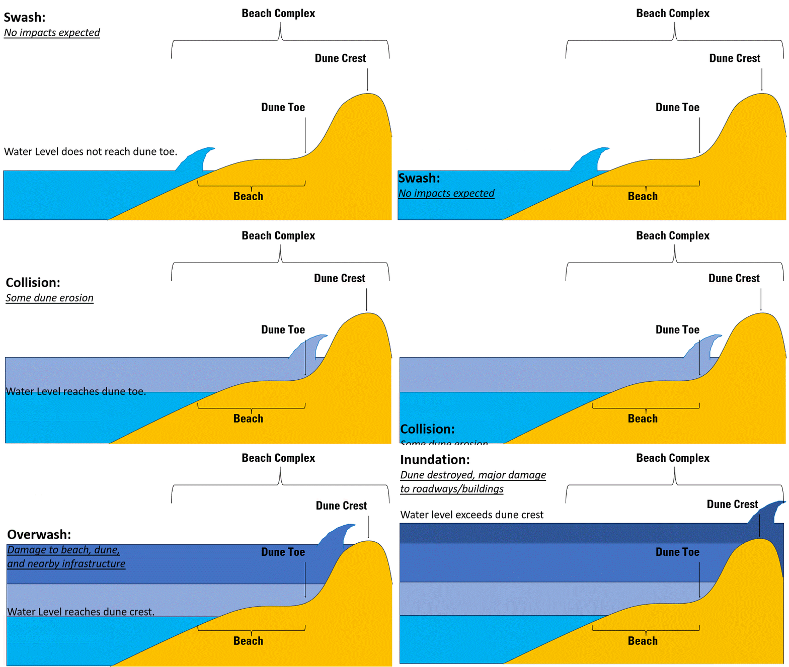
As you can see from the storm impact regime levels (Images 4-7), a beach's risk of damage during a storm depends on how high the water rises compared to the position of the dune toe (also called dune base) and dune crest (or the berm crest, or a man-made structure, etc.).
The vulnerability of a beach complex to storm overwash and inundation is determined by the water level relative to the dune crest. The distance between human infrastructure and the ocean, along with the size of these beach defenses, can vary widely even over short stretches of shoreline, which makes managing these areas more complex.
In some cases, a healthy dune can exist immediately adjacent to an area with no dune. A tall, wide dune with an elevated crest plays an important role in decreasing risk from storm-driven coastal change, compared to stretches of beach with very low dunes.
This variation is sometimes due to natural differences in the landscape, and other times due to a previous storm or human activity (for example, a walkway cut through a dune to let pedestrians pass from a road or parking lot to the beach).
As the storm impact regime shifts from collision to inundation, the beach system changes in several ways — including the position of the dune toe and the height of the dune crest — but these changes are not shown in the example images provided.
The big picture and the science behind it: The overview introduces the topic; the "Let's Get Technical" pages cover the beach complex, dunes, and water levels in detail.
How Storm-Impact Regimes Affect Beach Complexes: Coastal Hazards - Overview
Let's Get Technical: Beach Complex
Let's Get Technical: Dunes & Beach Metrics
Let's Get Technical: Water Levels
How severe is a coastal storm? Explore the four storm-impact regimes of increasing severity, from swash to inundation.
Swash Regime
Collision Regime
Overwash Regime
Inundation Regime

Storm-Induced Coastal Change

Scenario-Based Assessments for Coastal Change Hazard Forecasts

Storm-Induced Coastal Processes

Forecasting Coastal Change
This webpage explains coastal hazards caused by high water at the coast. These high-water levels, called "total water levels," happen when tides, waves, and storms combine and push the ocean higher than normal. This page provides an overview for community planners, emergency managers, and anyone else who wants to understand these risks.
Overview
This overview page is the starting point for an eight-page series on coastal storm-impact regimes, or storm-impact scale. The series continues with three "Let's Get Technical" deep dives (Beach Complex, Dunes & Beach Metrics, and Water Levels), and four pages describing the storm-impact regimes (Swash, Collision, Overwash, and Inundation). You can explore the full set through the linked text or the clickable tiles at the bottom of this page.
Every beach faces some risk from storms and high water, but how much risk depends on the storm and the shape of the beach. Scientists sort storm conditions into four categories, called regimes (a regime is a pattern, or set of conditions). As water rises during a storm, a beach moves through these four regimes, one after another, each riskier than the last:
- Swash regime: Everyday wave conditions. Waves wash up and down the beach but don’t reach the dune.
- Collision regime: Water rises high enough that waves crash directly into the dune, wearing it away.
- Overwash regime: Water rises to the top of the dune, and waves push sand over the top and further inland.
- Inundation regime: Water completely covers the dune and the area behind it, like a flood.
Which regime happens during a storm depends on two things: how strong the storm is (tides, storm surge, and waves) and the shape of the beach itself — including how tall its dune is.
(See Images 1A and B, below. For more information, see Let's Get Technical: Beach Complex.)
A dune acts like a first line of defense, protecting nearby homes, businesses, roads, and lives from storm damage. Knowing how well a dune will hold up when water levels rise is an important part of management planning for coastal communities. Beaches with very low or missing dunes are more likely to see major damage as water levels change during a storm (see Let's Get Technical: Dunes & Beach Metrics.)
Scientists can estimate how much danger a stretch of coast faces by comparing two things: how high the water gets during a storm (the elevation of ocean water levels, including storm surge, astronomical tide, and wave dynamics), and how tall the beach’s natural defenses are (Sallenger, 2000).
This model was first developed for barrier islands but works just as well for any sandy coast. That natural defense is usually a dune, measured at its highest point, called the dune crest.
(See Images 1A and B, above, and Images 2A, B, and C, below.)
Where there’s no dune, the same idea applies to the berm: the flat, dry part of the beach that stays dry and above water even at high tide.
Sometimes a human-made structure, like a seawall, or temporary measures, like sandbags, geotubes, or moveable walls play this same protective role. Knowing the height and condition of these defenses — natural or human-made — helps community planners and emergency managers prepare for, respond to, and recover from storms.
(See Images 3A and B, below.)
Storm-induced regimes
Storm-induced water levels are the highest point that water (from the combination of tides, storm surge and influence of storm waves) reach on the beach during a storm (see Let's Get Technical: Water Levels).
These four storm-impact regimes are defined by how the water level compares to the height of the dune or berm. Below is a brief description of each regime, along with an image (Images 4-7) and a link to more detailed information about the regime and risks to the beach and nearby communities. Each image (4-7) shows the same beach system, with water levels rising higher in each one.
As water levels rise, risk to the beach increases through each regime in turn: swash, collision, overwash, and inundation. Note: the dune looks the same in Image 4 through 7, but in reality, it would change shape in Images 5-7. That change isn’t consistent enough to show accurately in a drawing. Read each image caption to learn more about how the dune would actually respond.
Swash Regime
(Risk to Beach: Minimal to none; Risk to people/infrastructure: None)
The swash regime describes everyday wave conditions, when the wash of small waves runs up and down the beach face without reaching the dune. Any resulting erosion is temporary. Sand moved offshore during a storm typically returns to the beach naturally over the following weeks to months. This is essentially the “typical” condition for a beach, and it is unlikely to erode sand or create a risk. Depending on the beach, there may be limited dry sand to enjoy during high tide. Total water levels, including tide, surge, and waves, stay below the dune toe (Image 4).
Collision Regime
(Risk to beach/dune: Elevated; Risk to people/infrastructure: Minimal to none)
In the collision regime, waves reach the dune itself and break directly against it, rather than against the open beach, causing the dune to erode and retreat. Unlike the temporary sand loss of the swash regime, this dune erosion is a longer-lasting change to the beach system.
This loss of sand reduces the beach area available for recreation. Negative impacts to the beach typically last a few weeks, during which time storm protection from the beach complex may also be reduced.
In this regime, there is no threat to buildings, roads, or people behind the dune. Total water levels (including tide, surge, and waves) exceed the dune toe (Image 5).
Overwash Regime
(Risk to beach/dune: Extreme; Risk to people/infrastructure: Elevated)
In the overwash regime, water rises high enough to flow over the top of the dune, carrying sand from the beach and dune inland with it. Because that sand does not return, overwash produces a more permanent, net change to the beach system.
The beach is greatly altered and degraded. This poses an elevated threat to buildings and roads immediately behind the dune, creating the potential for economic losses and difficulty with transit. Total water levels, including tide, surge, and waves, reach the dune crest (Image 6).
Inundation Regime
(Risk to beach complex: Extreme; Risk to people/infrastructure: Extreme)
In the inundation regime, water levels, including tide and storm surge, are high enough to exceed the dune crest, completely submerging the dune and the area behind it, rather than washing over it briefly, wave by wave, as in overwash.
This regime carries sand much farther inland and produces the most significant, long-lasting change to the beach system. Severe impacts can include damage to buildings, destruction of roads and bridges, and loss of life. Additional impacts can also include long-term environmental damage such as habitat loss and water and sewage contamination, along with years of economic disruption for the tourism and fishing industries (Image 7).
Putting it all together
As you can see from the storm impact regime levels (Images 4-7), a beach's risk of damage during a storm depends on how high the water rises compared to the position of the dune toe (also called dune base) and dune crest (or the berm crest, or a man-made structure, etc.).
The vulnerability of a beach complex to storm overwash and inundation is determined by the water level relative to the dune crest. The distance between human infrastructure and the ocean, along with the size of these beach defenses, can vary widely even over short stretches of shoreline, which makes managing these areas more complex.
In some cases, a healthy dune can exist immediately adjacent to an area with no dune. A tall, wide dune with an elevated crest plays an important role in decreasing risk from storm-driven coastal change, compared to stretches of beach with very low dunes.
This variation is sometimes due to natural differences in the landscape, and other times due to a previous storm or human activity (for example, a walkway cut through a dune to let pedestrians pass from a road or parking lot to the beach).
As the storm impact regime shifts from collision to inundation, the beach system changes in several ways — including the position of the dune toe and the height of the dune crest — but these changes are not shown in the example images provided.
The big picture and the science behind it: The overview introduces the topic; the "Let's Get Technical" pages cover the beach complex, dunes, and water levels in detail.
How Storm-Impact Regimes Affect Beach Complexes: Coastal Hazards - Overview
Let's Get Technical: Beach Complex
Let's Get Technical: Dunes & Beach Metrics
Let's Get Technical: Water Levels
How severe is a coastal storm? Explore the four storm-impact regimes of increasing severity, from swash to inundation.
Swash Regime
Collision Regime
Overwash Regime
Inundation Regime
Storm-Induced Coastal Change
Scenario-Based Assessments for Coastal Change Hazard Forecasts
Storm-Induced Coastal Processes