



This informational webpage provides an overview to community planners and emergency managers regarding the coastal hazards associated with inundation, a regime within the storm impact scale. This page describes the conditions that lead to the inundation regime and the risks it poses to the beach and adjacent communities. Inundation is the fourth of four storm-impact regimes and is the most severe, leading to devastating risks to local communities, months to years of community recovery, and a substantial financial burden.
This page is part of an eight-page series on coastal storm-impact regimes, or storm-impact scale. It builds on the overview page How Storm-Impact Regimes Affect Beach Complexes: Coastal Hazards, three "Let's Get Technical" deep dives (Beach Complex, Dunes & Beach Metrics, and Water Levels), and four pages describing the storm-impact regimes (Swash, Collision, Overwash, and Inundation). You can explore the full set through the linked text or the clickable tiles at the bottom of this page. We suggest reading the How Storm-Impact Regimes Affect Beach Complexes: Coastal Hazards overview and the Overwash Regime pages first.
Inundation Regime
The inundation regime occurs when the total water level from tides, storm surge, and wave runup exceeds the dune crest, inundating (putting under water) any structures or vegetation behind the dune. In severe cases, the portion of the ocean that has breaking waves could be landward of the beach complex, causing waves to break on homes and businesses.
The inundation regime has many of the same hazards as the overwash regime, but with a higher likelihood of severe impacts to the beach complex and adjacent communities. The beach could erode, exporting some sand seaward from the system while moving a considerable amount of sand landward of the dune (onto roads, homes, and businesses).
The extent of this landward sand deposit can reach hundreds of feet, affecting communities well inland of the beach. The sand deposit can be inches to feet deep, severely impacting travel on roads, filling the interiors of coastal structures, and filling in waterways. In addition to sand transported inland, inundation can cause severe flooding of roads and buildings.
While local variability in the beach complex may cause alongshore inconsistencies in impact, the damage remains widespread, as the entire beach complex is underwater, affecting continuous stretches of the coastline.

Catastrophic Impacts of the Inundation Regime
Inundation can severely impact the beach complex. Extensive erosion of the beach complex and complete flattening of the dune are possible. In some cases, the water rises so quickly that portions of the dune may survive.
Barrier islands may be breached, opening new inlets in the islands (Image 2), and demolishing any homes that previously stood where the breach occurred. While many homes can withstand high winds and simple flooding, few homes can withstand the force of waves pounding directly on the structure. Roads and bridges can be impassable due to sand, as well as extensive debris and rubble that is left on transit pathways.
The infrastructure itself is likely to be severely damaged, with whole sections of bridge or road missing and hard to see, due to sand and debris deposits. Homes and businesses become severely damaged and may not be repairable. Damage to cars will typically result in a total loss; fires from wet vehicle batteries will be common and power, water, and sewer lines can be damaged. It will take multiple days to more than a week for basic recovery of infrastructure that allows the initial return of residents and assessment of personal property damage.
Repairs that would allow for a return of critical services (power, water, sewage) can take much longer. Repairs that allow businesses to safely resume operation are likely to take months to years. At the community level, full recovery to pre-storm conditions (if possible) often takes years. This level of impact is no longer rare: storms that reach the inundation regime have been relatively frequent since the start of the 21st century. Coastal populations continue to grow in the path of severe storms, increasing the risk these storms pose.

On August 29, 2005, Hurricane Katrina made landfall as a Category 3 storm over the Mississippi Delta in Louisiana. This strong storm approached the coast with Category 4 strength winds, building large waves and record levels of water (near 28 feet), unmatched prior or since.
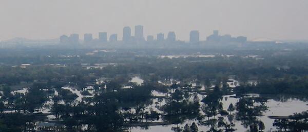
Using that extreme storm as a “start” time, the United States has been devastated by major storms reaching the inundation regime 18 times:
Rita (LA) in 2005; Ike (TX, LA, FL, MS) in 2008; Superstorm Sandy (NJ, NY) in 2012; Matthew (FL, GA, SC, NC) in 2016; Harvey (TX), Irma (FL), and Maria (Puerto Rico) in 2017; Florence (NC) and Michael (FL) in 2018; Laura (LA), Sally (AL, FL), Delta (LA) and Zeta (MS, AL, LA) in 2020; Ida (LA) in 2021; Ian (FL, SC, NC) in 2022; Idalia (FL) in 2023; and Helene (FL, GA, NC, SC) and Milton (FL, GA) in 2024. (Note, the states listed were impacted but may not have all reached the inundation regime.)

The big picture and the science behind it: The overview introduces the topic; the "Let's Get Technical" pages cover the beach complex, dunes, and water levels in detail.
How Storm-Impact Regimes Affect Beach Complexes: Coastal Hazards - Overview
Let's Get Technical: Beach Complex
Let's Get Technical: Dunes & Beach Metrics
Let's Get Technical: Water Levels
How severe is a coastal storm? Explore the four storm-impact regimes of increasing severity, from swash to inundation.
Swash Regime
Collision Regime
Overwash Regime
Inundation Regime

Swash Regime
Collision Regime

Overwash Regime

Let’s Get Technical: Beach Complex
Let’s Get Technical: Dunes & Beach Metrics

Let's Get Technical: Water Levels
How Storm-Impact Regimes Affect Beach Complexes: Coastal Hazards

Monitoring Storm Tide and Flooding From Hurricane Irma Along the U.S. Virgin Islands, Puerto Rico, and the Southeastern United States
This informational webpage provides an overview to community planners and emergency managers regarding the coastal hazards associated with inundation, a regime within the storm impact scale. This page describes the conditions that lead to the inundation regime and the risks it poses to the beach and adjacent communities. Inundation is the fourth of four storm-impact regimes and is the most severe, leading to devastating risks to local communities, months to years of community recovery, and a substantial financial burden.
This page is part of an eight-page series on coastal storm-impact regimes, or storm-impact scale. It builds on the overview page How Storm-Impact Regimes Affect Beach Complexes: Coastal Hazards, three "Let's Get Technical" deep dives (Beach Complex, Dunes & Beach Metrics, and Water Levels), and four pages describing the storm-impact regimes (Swash, Collision, Overwash, and Inundation). You can explore the full set through the linked text or the clickable tiles at the bottom of this page. We suggest reading the How Storm-Impact Regimes Affect Beach Complexes: Coastal Hazards overview and the Overwash Regime pages first.
Inundation Regime
The inundation regime occurs when the total water level from tides, storm surge, and wave runup exceeds the dune crest, inundating (putting under water) any structures or vegetation behind the dune. In severe cases, the portion of the ocean that has breaking waves could be landward of the beach complex, causing waves to break on homes and businesses.
The inundation regime has many of the same hazards as the overwash regime, but with a higher likelihood of severe impacts to the beach complex and adjacent communities. The beach could erode, exporting some sand seaward from the system while moving a considerable amount of sand landward of the dune (onto roads, homes, and businesses).
The extent of this landward sand deposit can reach hundreds of feet, affecting communities well inland of the beach. The sand deposit can be inches to feet deep, severely impacting travel on roads, filling the interiors of coastal structures, and filling in waterways. In addition to sand transported inland, inundation can cause severe flooding of roads and buildings.
While local variability in the beach complex may cause alongshore inconsistencies in impact, the damage remains widespread, as the entire beach complex is underwater, affecting continuous stretches of the coastline.
Catastrophic Impacts of the Inundation Regime
Inundation can severely impact the beach complex. Extensive erosion of the beach complex and complete flattening of the dune are possible. In some cases, the water rises so quickly that portions of the dune may survive.
Barrier islands may be breached, opening new inlets in the islands (Image 2), and demolishing any homes that previously stood where the breach occurred. While many homes can withstand high winds and simple flooding, few homes can withstand the force of waves pounding directly on the structure. Roads and bridges can be impassable due to sand, as well as extensive debris and rubble that is left on transit pathways.
The infrastructure itself is likely to be severely damaged, with whole sections of bridge or road missing and hard to see, due to sand and debris deposits. Homes and businesses become severely damaged and may not be repairable. Damage to cars will typically result in a total loss; fires from wet vehicle batteries will be common and power, water, and sewer lines can be damaged. It will take multiple days to more than a week for basic recovery of infrastructure that allows the initial return of residents and assessment of personal property damage.
Repairs that would allow for a return of critical services (power, water, sewage) can take much longer. Repairs that allow businesses to safely resume operation are likely to take months to years. At the community level, full recovery to pre-storm conditions (if possible) often takes years. This level of impact is no longer rare: storms that reach the inundation regime have been relatively frequent since the start of the 21st century. Coastal populations continue to grow in the path of severe storms, increasing the risk these storms pose.
On August 29, 2005, Hurricane Katrina made landfall as a Category 3 storm over the Mississippi Delta in Louisiana. This strong storm approached the coast with Category 4 strength winds, building large waves and record levels of water (near 28 feet), unmatched prior or since.
Using that extreme storm as a “start” time, the United States has been devastated by major storms reaching the inundation regime 18 times:
Rita (LA) in 2005; Ike (TX, LA, FL, MS) in 2008; Superstorm Sandy (NJ, NY) in 2012; Matthew (FL, GA, SC, NC) in 2016; Harvey (TX), Irma (FL), and Maria (Puerto Rico) in 2017; Florence (NC) and Michael (FL) in 2018; Laura (LA), Sally (AL, FL), Delta (LA) and Zeta (MS, AL, LA) in 2020; Ida (LA) in 2021; Ian (FL, SC, NC) in 2022; Idalia (FL) in 2023; and Helene (FL, GA, NC, SC) and Milton (FL, GA) in 2024. (Note, the states listed were impacted but may not have all reached the inundation regime.)
The big picture and the science behind it: The overview introduces the topic; the "Let's Get Technical" pages cover the beach complex, dunes, and water levels in detail.
How Storm-Impact Regimes Affect Beach Complexes: Coastal Hazards - Overview
Let's Get Technical: Beach Complex
Let's Get Technical: Dunes & Beach Metrics
Let's Get Technical: Water Levels
How severe is a coastal storm? Explore the four storm-impact regimes of increasing severity, from swash to inundation.
Swash Regime
Collision Regime
Overwash Regime
Inundation Regime
Swash Regime
Collision Regime
Overwash Regime
Let’s Get Technical: Beach Complex
Let’s Get Technical: Dunes & Beach Metrics
Let's Get Technical: Water Levels
How Storm-Impact Regimes Affect Beach Complexes: Coastal Hazards