



Our coast is valuable and so is the science that protects it.
Let’s Get Technical: Beach Complex
Active
By St. Petersburg Coastal and Marine Science Center
October 29, 2026
This webpage expands on the concept of the beach complex introduced on the storm-impact regime homepage. It clarifies the morphological (beach shape) markers used to assess the impact of elevated water levels and relates them to the swash, collision, overwash, and inundation regimes. It also introduces additional terms used by professionals to describe these same features (such as dune toe and dune base). Readers who want more technical details can follow the links to see how these water-level and morphological markers are determined.
This page is part of an eight-page series on coastal storm-impact regimes, or storm-impact scale. It builds on the overview page How Storm-Impact Regimes Affect Beach Complexes: Coastal Hazards, which we recommend reading first, continues with two other "Let's Get Technical" deep dives (Dunes & Beach Metrics and Water Levels), and four pages describing the storm-impact regimes (Swash, Collision, Overwash, and Inundation). You can explore the full set through the linked text or the clickable tiles at the bottom of this page.
Overview
Overview
Media
Sources/Usage: Public Domain. View Media Details
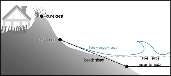
Our storm impact regime model relies on establishing specific reference points across the beach complex to assess the risk of hazards to the beach, dune, and infrastructure.
To fully assess storm impact, however, we must also account for every contribution to the total water level relative to these reference points.
Beach Complex
The coastal area, called a beach complex or beach system, is divided into functional segments based on how ocean processes and wind influence each one. The beach is the section of the system that extends from the low-tide influence to the dune base ("dune base" and "dune toe" are used interchangeably).
The berm is the portion of the beach above the highest high tide line and extending to the dune base; it makes up the largest portion of the backshore (the area from average high tide to the dune base).
The dune forms from the accumulation of wind-blown sand and serves as the most important protective feature against storm hazards. The width of the dune, the position and elevation of the dune base, and the height of the dune crest all play a role in mitigating coastal storm impacts and protecting coastal resources. The dune base and dune crest are calculated from extensive beach measurements, as described on the Let's Get Technical: Dunes & Beach Metrics page.
Media
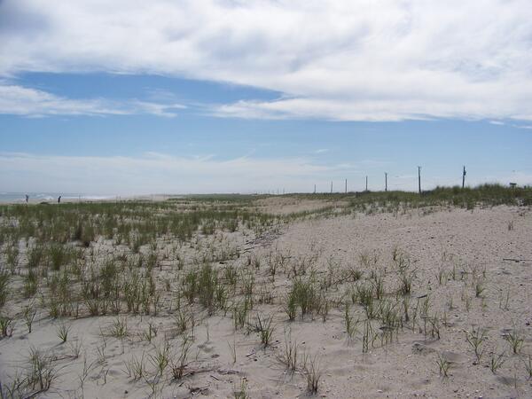
Image 2A. A typical beach system east of Shinnecock Inlet on Long Island, NY, near Ponquogue Beach, with a developed berm, dune toe/base, and dune crest. The dune is healthy, with a wide vegetated section leading up to a tall crest.
Sources/Usage: Public Domain. View Media Details
Media
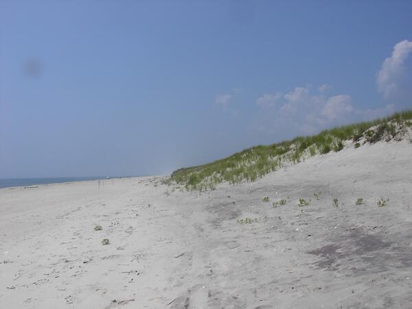
Image 2B. A tall, vegetated dune at Ponquogue Beach, Long Island, New York, with the dune toe and dune crest visible. Extended dune development has created a wide additional dune portion seaward of the existing dune toe/base, known as an embryonic dune.
Sources/Usage: Public Domain. View Media Details
Under normal conditions, the beach slope shown in Figure 1 runs from the position of mean high water (the average high-water level over several years) to the dune base (also commonly referred to as the dune toe). During a storm, however, the water level rises well above mean high water and moves up the beach slope, putting the dune at risk of damage.
In these cases, the base water level is equal to the tide+surge+wave setup and is referred to as mean water level. To fully account for the water level impacts, we also need to include swash in order to calculate wave runup and total water level denoted in Figure 1 by the blue line. A full explanation of how mean water level and total water level are modeled can be found on the Let’s Get Technical: Water Levels page.
We can relate the position of the water level and dune morphology (dune crest and dune base) to each of the four storm-impact regimes, described below.
Swash Regime:
Media
Sources/Usage: Public Domain. View Media Details
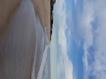
A “typical” day where there is no surge or significantly larger-than-normal waves. Total water levels stay below the dune toe (Total water level < dune base).
Collision Regime:
Media
Sources/Usage: Public Domain. View Media Details
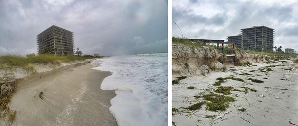
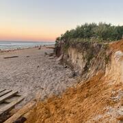
Tides, waves, and surge are higher than typical, allowing swash from waves to reach the dune base and undercut the dune. This can lead to erosion of the dune face, resulting in a scarp (a near vertical face) on the dune. Total water levels reach or slightly exceed the dune toe (dune base < total water level < dune crest).
Overwash Regime:
Media
Sources/Usage: Public Domain. View Media Details
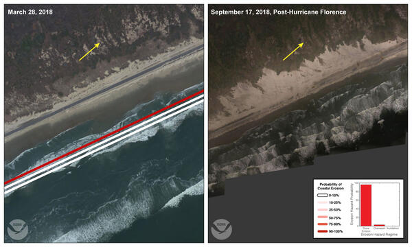
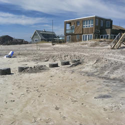
Tides and surge are elevated, allowing waves to break on and over the dune crest, and wash sand inland, behind the dune. This can lead to sand and water impacting infrastructure, such as roads becoming partially covered in sand. Total water levels reach very near the top of the dune and waves impact the dune crest (total water level ≥ dune crest).
Inundation Regime:
Media
Sources/Usage: Public Domain. View Media Details
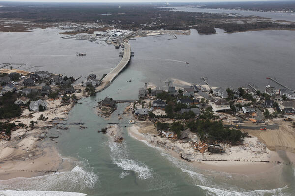
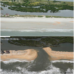
Tides and surge become extremely elevated, causing water completely flood the dune crest. This causes flooding in coastal communities, severely damages or completely flattens the dune, and transports a substantial volume of sand well landward of the beach complex. Storm surge, tide and wave setup exceed the dune crest (mean water level > dune crest).
The big picture and the science behind it: The overview page introduces the topic; the "Let's Get Technical" pages explain the beach complex, dunes, and water levels in detail.
The big picture and the science behind it: The overview page introduces the topic; the "Let's Get Technical" pages explain the beach complex, dunes, and water levels in detail.
How Storm-Impact Regimes Affect Beach Complexes: Coastal Hazards - overview
How Storm-Impact Regimes Affect Beach Complexes: Coastal Hazards - overview
How Storm-Impact Regimes Affect Beach Complexes: Coastal Hazards - overview
Let's Get Technical: Beach Complex
Let's Get Technical: Beach Complex
Let's Get Technical: Beach Complex
Let's Get Technical: Dunes & Beach Metrics
Let's Get Technical: Dunes & Beach Metrics
Let's Get Technical: Dunes & Beach Metrics
Let's Get Technical: Water Levels
Let's Get Technical: Water Levels
Let's Get Technical: Water Levels
How severe is a coastal storm? Explore the four storm-impact regimes that describe increasing storm severity, from swash to inundation.
How severe is a coastal storm? Explore the four storm-impact regimes that describe increasing storm severity, from swash to inundation.
Swash Regime
Swash Regime
Swash Regime
Collision Regime
Collision Regime
Collision Regime
Overwash Regime
Overwash Regime
Overwash Regime
Inundation Regime
Inundation Regime
Inundation Regime

Overwash Regime
This informational webpage provides an overview to community planners and emergency managers regarding coastal hazards associated with overwash, a regime within the storm impact scale. This page describes the conditions that lead to the overwash regime and the risks it poses to the beach and local community. Overwash is the third of four storm-impact regimes and leads to considerable impacts on...

Swash Regime
This informational webpage describes the swash regime, including depictions of the beach complex under its influence (Image 1), the conditions that define it, and any risks to the beach complex. Swash is the first of four storm-impact regimes, with minimal to no impacts expected from it.
Collision Regime
This informational webpage provides an overview to community planners and emergency managers regarding the coastal hazards associated with collision, a regime within the storm impact scale. This page describes the conditions that lead to a collision regime and the risks it poses to local resources. Collision is the second of four storm impact regimes, and the first regime where substantial impacts...
Inundation Regime
This informational webpage provides an overview to community planners and emergency managers regarding the coastal hazards associated with inundation, a regime within the storm impact scale. This page describes the conditions that lead to the inundation regime and the risks it poses to the beach and adjacent communities. Inundation is the fourth of four storm-impact regimes and is the most severe...
Let’s Get Technical: Dunes & Beach Metrics
This webpage provides technical details regarding how the USGS calculates beach metrics related to morphology features; specifically, the dune crest position and elevation, the dune base/toe position and elevation and beach slope. This is a brief overview of that process with links and references to the full source material.

Let's Get Technical: Water Levels
This webpage provides a technical description of how water levels are defined and calculated during a coastal storm event (such as a hurricane). It describes how the USGS team calculates the peak water level against which a reference beach complex is modeled in order to determine risks.
How Storm-Impact Regimes Affect Beach Complexes: Coastal Hazards
This webpage explains coastal hazards caused by high water at the coast. These high-water levels, called "total water levels," happen when tides, waves, and storms combine and push the ocean higher than normal. This page provides an overview for community planners, emergency managers, and anyone else who wants to understand these risks.

Digital Shoreline Analysis System (DSAS)
Software for calculating positional boundary change over time The Digital Shoreline Analysis System (DSAS) version 6 is a standalone application that calculates shoreline or boundary change over time. The GIS of a user’s choice is used to prepare the data for DSAS. Like previous versions, DSAS v.6 enables a user to calculate rate-of-change statistics from multiple historical shoreline positions...

Shoreface Morphology and Geology
Exchanges of sediment between the shoreface and barrier islands allow barrier islands to adjust to changes in water level, such as those associated with storms or sea-level rise. Characterizing shoreface morphology and geology allows us to explore how past and present processes have impacted modern barrier island sediment transport and what that means for future barrier island evolution.

Coastal Sediment Availability and Flux (CSAF)
Sediments are the foundation of coastal systems, including barrier islands. Their behavior is driven by not only sediment availability, but also sediment exchanges between barrier island environments. We collect geophysical, remote sensing, and sediment data to estimate these parameters, which are integrated with models to improve prediction of coastal response to extreme storms and sea-level rise...

Beach Change Envelope - Coastal System Change at Fire Island, New York
Given the unique challenges in quantifying the extensive, yet variable impacts of Hurricane Sandy at Fire Island, we used a time series of beach profile data at Fire Island, New York, to define a new contour-based morphologic change metric, the Beach Change Envelope (BCE).

Our Coasts are Valuable
Our coast is valuable and so is the science that protects it.

Coastal Change Likelihood
The CCL is an updated version of the older Coastal Vulnerability Index, first published in 1999. While the original product was focused on change in the next 50-100 years based solely on sea level rise, the new CCL is more near-term, focusing on change over the next decade as a result of multiple coastal hazards.
The CCL is an updated version of the older Coastal Vulnerability Index, first published in 1999. While the original product was focused on change in the next 50-100 years based solely on sea level rise, the new CCL is more near-term, focusing on change over the next decade as a result of multiple coastal hazards.
This webpage expands on the concept of the beach complex introduced on the storm-impact regime homepage. It clarifies the morphological (beach shape) markers used to assess the impact of elevated water levels and relates them to the swash, collision, overwash, and inundation regimes. It also introduces additional terms used by professionals to describe these same features (such as dune toe and dune base). Readers who want more technical details can follow the links to see how these water-level and morphological markers are determined.
This page is part of an eight-page series on coastal storm-impact regimes, or storm-impact scale. It builds on the overview page How Storm-Impact Regimes Affect Beach Complexes: Coastal Hazards, which we recommend reading first, continues with two other "Let's Get Technical" deep dives (Dunes & Beach Metrics and Water Levels), and four pages describing the storm-impact regimes (Swash, Collision, Overwash, and Inundation). You can explore the full set through the linked text or the clickable tiles at the bottom of this page.
Overview
Overview
Media
Sources/Usage: Public Domain. View Media Details
Our storm impact regime model relies on establishing specific reference points across the beach complex to assess the risk of hazards to the beach, dune, and infrastructure.
To fully assess storm impact, however, we must also account for every contribution to the total water level relative to these reference points.
Beach Complex
The coastal area, called a beach complex or beach system, is divided into functional segments based on how ocean processes and wind influence each one. The beach is the section of the system that extends from the low-tide influence to the dune base ("dune base" and "dune toe" are used interchangeably).
The berm is the portion of the beach above the highest high tide line and extending to the dune base; it makes up the largest portion of the backshore (the area from average high tide to the dune base).
The dune forms from the accumulation of wind-blown sand and serves as the most important protective feature against storm hazards. The width of the dune, the position and elevation of the dune base, and the height of the dune crest all play a role in mitigating coastal storm impacts and protecting coastal resources. The dune base and dune crest are calculated from extensive beach measurements, as described on the Let's Get Technical: Dunes & Beach Metrics page.
Media
Image 2A. A typical beach system east of Shinnecock Inlet on Long Island, NY, near Ponquogue Beach, with a developed berm, dune toe/base, and dune crest. The dune is healthy, with a wide vegetated section leading up to a tall crest.
Sources/Usage: Public Domain. View Media Details
Media
Image 2B. A tall, vegetated dune at Ponquogue Beach, Long Island, New York, with the dune toe and dune crest visible. Extended dune development has created a wide additional dune portion seaward of the existing dune toe/base, known as an embryonic dune.
Sources/Usage: Public Domain. View Media Details
Under normal conditions, the beach slope shown in Figure 1 runs from the position of mean high water (the average high-water level over several years) to the dune base (also commonly referred to as the dune toe). During a storm, however, the water level rises well above mean high water and moves up the beach slope, putting the dune at risk of damage.
In these cases, the base water level is equal to the tide+surge+wave setup and is referred to as mean water level. To fully account for the water level impacts, we also need to include swash in order to calculate wave runup and total water level denoted in Figure 1 by the blue line. A full explanation of how mean water level and total water level are modeled can be found on the Let’s Get Technical: Water Levels page.
We can relate the position of the water level and dune morphology (dune crest and dune base) to each of the four storm-impact regimes, described below.
Swash Regime:
Media
Sources/Usage: Public Domain. View Media Details
A “typical” day where there is no surge or significantly larger-than-normal waves. Total water levels stay below the dune toe (Total water level < dune base).
Collision Regime:
Media
Sources/Usage: Public Domain. View Media Details
Tides, waves, and surge are higher than typical, allowing swash from waves to reach the dune base and undercut the dune. This can lead to erosion of the dune face, resulting in a scarp (a near vertical face) on the dune. Total water levels reach or slightly exceed the dune toe (dune base < total water level < dune crest).
Overwash Regime:
Media
Sources/Usage: Public Domain. View Media Details
Tides and surge are elevated, allowing waves to break on and over the dune crest, and wash sand inland, behind the dune. This can lead to sand and water impacting infrastructure, such as roads becoming partially covered in sand. Total water levels reach very near the top of the dune and waves impact the dune crest (total water level ≥ dune crest).
Inundation Regime:
Media
Sources/Usage: Public Domain. View Media Details
Tides and surge become extremely elevated, causing water completely flood the dune crest. This causes flooding in coastal communities, severely damages or completely flattens the dune, and transports a substantial volume of sand well landward of the beach complex. Storm surge, tide and wave setup exceed the dune crest (mean water level > dune crest).
The big picture and the science behind it: The overview page introduces the topic; the "Let's Get Technical" pages explain the beach complex, dunes, and water levels in detail.
The big picture and the science behind it: The overview page introduces the topic; the "Let's Get Technical" pages explain the beach complex, dunes, and water levels in detail.
How Storm-Impact Regimes Affect Beach Complexes: Coastal Hazards - overview
How Storm-Impact Regimes Affect Beach Complexes: Coastal Hazards - overview
How Storm-Impact Regimes Affect Beach Complexes: Coastal Hazards - overview
Let's Get Technical: Beach Complex
Let's Get Technical: Beach Complex
Let's Get Technical: Beach Complex
Let's Get Technical: Dunes & Beach Metrics
Let's Get Technical: Dunes & Beach Metrics
Let's Get Technical: Dunes & Beach Metrics
Let's Get Technical: Water Levels
Let's Get Technical: Water Levels
Let's Get Technical: Water Levels
How severe is a coastal storm? Explore the four storm-impact regimes that describe increasing storm severity, from swash to inundation.
How severe is a coastal storm? Explore the four storm-impact regimes that describe increasing storm severity, from swash to inundation.
Swash Regime
Swash Regime
Swash Regime
Collision Regime
Collision Regime
Collision Regime
Overwash Regime
Overwash Regime
Overwash Regime
Inundation Regime
Inundation Regime
Inundation Regime
Overwash Regime
This informational webpage provides an overview to community planners and emergency managers regarding coastal hazards associated with overwash, a regime within the storm impact scale. This page describes the conditions that lead to the overwash regime and the risks it poses to the beach and local community. Overwash is the third of four storm-impact regimes and leads to considerable impacts on...
Swash Regime
This informational webpage describes the swash regime, including depictions of the beach complex under its influence (Image 1), the conditions that define it, and any risks to the beach complex. Swash is the first of four storm-impact regimes, with minimal to no impacts expected from it.
Collision Regime
This informational webpage provides an overview to community planners and emergency managers regarding the coastal hazards associated with collision, a regime within the storm impact scale. This page describes the conditions that lead to a collision regime and the risks it poses to local resources. Collision is the second of four storm impact regimes, and the first regime where substantial impacts...
Inundation Regime
This informational webpage provides an overview to community planners and emergency managers regarding the coastal hazards associated with inundation, a regime within the storm impact scale. This page describes the conditions that lead to the inundation regime and the risks it poses to the beach and adjacent communities. Inundation is the fourth of four storm-impact regimes and is the most severe...
Let’s Get Technical: Dunes & Beach Metrics
This webpage provides technical details regarding how the USGS calculates beach metrics related to morphology features; specifically, the dune crest position and elevation, the dune base/toe position and elevation and beach slope. This is a brief overview of that process with links and references to the full source material.
Let's Get Technical: Water Levels
This webpage provides a technical description of how water levels are defined and calculated during a coastal storm event (such as a hurricane). It describes how the USGS team calculates the peak water level against which a reference beach complex is modeled in order to determine risks.
How Storm-Impact Regimes Affect Beach Complexes: Coastal Hazards
This webpage explains coastal hazards caused by high water at the coast. These high-water levels, called "total water levels," happen when tides, waves, and storms combine and push the ocean higher than normal. This page provides an overview for community planners, emergency managers, and anyone else who wants to understand these risks.
Digital Shoreline Analysis System (DSAS)
Software for calculating positional boundary change over time The Digital Shoreline Analysis System (DSAS) version 6 is a standalone application that calculates shoreline or boundary change over time. The GIS of a user’s choice is used to prepare the data for DSAS. Like previous versions, DSAS v.6 enables a user to calculate rate-of-change statistics from multiple historical shoreline positions...
Shoreface Morphology and Geology
Exchanges of sediment between the shoreface and barrier islands allow barrier islands to adjust to changes in water level, such as those associated with storms or sea-level rise. Characterizing shoreface morphology and geology allows us to explore how past and present processes have impacted modern barrier island sediment transport and what that means for future barrier island evolution.
Coastal Sediment Availability and Flux (CSAF)
Sediments are the foundation of coastal systems, including barrier islands. Their behavior is driven by not only sediment availability, but also sediment exchanges between barrier island environments. We collect geophysical, remote sensing, and sediment data to estimate these parameters, which are integrated with models to improve prediction of coastal response to extreme storms and sea-level rise...
Beach Change Envelope - Coastal System Change at Fire Island, New York
Given the unique challenges in quantifying the extensive, yet variable impacts of Hurricane Sandy at Fire Island, we used a time series of beach profile data at Fire Island, New York, to define a new contour-based morphologic change metric, the Beach Change Envelope (BCE).
Our Coasts are Valuable
Our coast is valuable and so is the science that protects it.
Our coast is valuable and so is the science that protects it.
Coastal Change Likelihood
The CCL is an updated version of the older Coastal Vulnerability Index, first published in 1999. While the original product was focused on change in the next 50-100 years based solely on sea level rise, the new CCL is more near-term, focusing on change over the next decade as a result of multiple coastal hazards.
The CCL is an updated version of the older Coastal Vulnerability Index, first published in 1999. While the original product was focused on change in the next 50-100 years based solely on sea level rise, the new CCL is more near-term, focusing on change over the next decade as a result of multiple coastal hazards.