



Chloride concentrations in these studied northern U.S.
Images
Upper Midwest Water Science Center images.
Filter Total Items: 581

Chloride in Snowy Urban Watersheds
Chloride concentrations in these studied northern U.S.

Sediment core retrieval from Lake Erie onboard the RV Lake Guardian
Sediment core retrieval from Lake Erie onboard the RV Lake GuardianSediment core retrieval from Lake Erie onboard the RV Lake Guardian on Lake Erie, Michigan.
Sediment core retrieval from Lake Erie onboard the RV Lake Guardian
Sediment core retrieval from Lake Erie onboard the RV Lake GuardianSediment core retrieval from Lake Erie onboard the RV Lake Guardian on Lake Erie, Michigan.

Little Plover River Wells
Both irrigation wells and municipal wells affect water levels in the Little Plover River, Wisconsin.
Both irrigation wells and municipal wells affect water levels in the Little Plover River, Wisconsin.

Scientist collecting an Equal Width Increment (EWI) sample
Scientist collecting an Equal Width Increment (EWI) sampleUSGS scientist collecting an Equal width increment (EWI) sample on Bark River, Merton, WI.
Scientist collecting an Equal Width Increment (EWI) sample
Scientist collecting an Equal Width Increment (EWI) sampleUSGS scientist collecting an Equal width increment (EWI) sample on Bark River, Merton, WI.

USGS Scientists Collecting a Water Sample from a Well at the USGS Bemidji Research Site
USGS Scientists Collecting a Water Sample from a Well at the USGS Bemidji Research SiteU.S. Geological Survey (USGS) scientists collecting a groundwater sample from a well at the USGS Bemidji Crude-Oil Spill Research Site, Minnesota. The scientists monitored in real time the dissolved oxygen, pH, specific conductance, and temperature of the water as the well is pumped so they can know when to collect representative sample.
USGS Scientists Collecting a Water Sample from a Well at the USGS Bemidji Research Site
USGS Scientists Collecting a Water Sample from a Well at the USGS Bemidji Research SiteU.S. Geological Survey (USGS) scientists collecting a groundwater sample from a well at the USGS Bemidji Crude-Oil Spill Research Site, Minnesota. The scientists monitored in real time the dissolved oxygen, pH, specific conductance, and temperature of the water as the well is pumped so they can know when to collect representative sample.
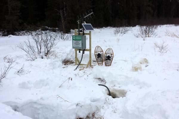
Streamgage 05124982 Filson Creek IN Swse Sec. 24, Near Winton, Minnesota
Streamgage 05124982 Filson Creek IN Swse Sec. 24, Near Winton, MinnesotaA pair of snowshoes rests in the snow next to a small streamgage mounted on a wooden frame, with antenna and solar panel. A black tube connected to the gage enters a hole in the snow in the foreground.
Streamgage 05124982 Filson Creek IN Swse Sec. 24, Near Winton, Minnesota
Streamgage 05124982 Filson Creek IN Swse Sec. 24, Near Winton, Minnesota
Streamgage 05124982 Filson Creek IN Swse Sec. 24, Near Winton, MinnesotaA pair of snowshoes rests in the snow next to a small streamgage mounted on a wooden frame, with antenna and solar panel. A black tube connected to the gage enters a hole in the snow in the foreground.
Streamgage 05124982 Filson Creek IN Swse Sec. 24, Near Winton, Minnesota

Cement-lined channels slowly being removed for stream rehabilitation
Cement-lined channels slowly being removed for stream rehabilitationCement-lined channels such as this one in a section of the Kinnickinnic River at 11th Street in Milwaukee are slowly being removed in stream rehabilitation efforts. Water chemistry remains important, and this channel shows abundant algal growth from excess nutrients and abundant sunlight.
Cement-lined channels slowly being removed for stream rehabilitation
Cement-lined channels slowly being removed for stream rehabilitationCement-lined channels such as this one in a section of the Kinnickinnic River at 11th Street in Milwaukee are slowly being removed in stream rehabilitation efforts. Water chemistry remains important, and this channel shows abundant algal growth from excess nutrients and abundant sunlight.

Sediment core collected from a contaminated aquifer in Bemidji
Sediment core collected from a contaminated aquifer in BemidjiResearch Hydrologist Isabelle Cozzarelli holds a sediment core collected from a contaminated aquifer at the Bemidji National Crude Oil Spill Fate and Natural Attenuation Research Site. The sediment from the core is analyzed and used to measure iron, arsenic, and trace metals in the solid phase.
Sediment core collected from a contaminated aquifer in Bemidji
Sediment core collected from a contaminated aquifer in BemidjiResearch Hydrologist Isabelle Cozzarelli holds a sediment core collected from a contaminated aquifer at the Bemidji National Crude Oil Spill Fate and Natural Attenuation Research Site. The sediment from the core is analyzed and used to measure iron, arsenic, and trace metals in the solid phase.

2012 SPARROW Models for the Midwest
2012 SPARROW Models for the Midwest: Total Phosphorus, Total Nitrogen, Suspended Sediment, and Streamflow
2012 SPARROW Models for the Midwest: Total Phosphorus, Total Nitrogen, Suspended Sediment, and Streamflow

Stream reach of Underwood Creek's concrete lined channel
Stream reach of Underwood Creek's concrete lined channelAn example stream reach of Underwood Creek’s concrete lined channel before rehabilitation in 2012.
Stream reach of Underwood Creek's concrete lined channel
Stream reach of Underwood Creek's concrete lined channelAn example stream reach of Underwood Creek’s concrete lined channel before rehabilitation in 2012.

Monitoring wells at the National Crude Oil Spill Fate and Natural Attenuation Research Site near Bemidji, Minnesota
Monitoring wells at the National Crude Oil Spill Fate and Natural Attenuation Research Site near Bemidji, MinnesotaMonitoring wells near the location of a 1979 oil spill at the National Crude Oil Spill Fate and Natural Attenuation Research Site near Bemidji, Minnesota, in October 2010. Some are for sampling groundwater, some are for sampling soil gas, some are for sampling oil. The green PVC collar in the foreground is for measuring soil carbon dioxide (CO2) efflux.
Monitoring wells at the National Crude Oil Spill Fate and Natural Attenuation Research Site near Bemidji, Minnesota
Monitoring wells at the National Crude Oil Spill Fate and Natural Attenuation Research Site near Bemidji, MinnesotaMonitoring wells near the location of a 1979 oil spill at the National Crude Oil Spill Fate and Natural Attenuation Research Site near Bemidji, Minnesota, in October 2010. Some are for sampling groundwater, some are for sampling soil gas, some are for sampling oil. The green PVC collar in the foreground is for measuring soil carbon dioxide (CO2) efflux.

Measuring soil CO2 efflux
Measuring soil CO2 efflux at the Bemidji Crude Oil Spill research site
Measuring soil CO2 efflux at the Bemidji Crude Oil Spill research site

Fish are weighed and measured for length
Fish are identified and counted in the field, and game fish are measured for total length and weighed, before being released live back to the stream site.
Fish are identified and counted in the field, and game fish are measured for total length and weighed, before being released live back to the stream site.

WI WSC open house 2012: field boat
Photo of WI WSC staff member and his son exploring a field boat during the 2012 Wisconsin Water Science Center open house.
Photo of WI WSC staff member and his son exploring a field boat during the 2012 Wisconsin Water Science Center open house.

Sampling dragonfly larvae in Sand Point Lake
Sample of dragonfly larvae in water in bottom of zip-lock plastic bag, held at horizon level with lake. At Sand Point Lake in Voyageurs National Park.
Sample of dragonfly larvae in water in bottom of zip-lock plastic bag, held at horizon level with lake. At Sand Point Lake in Voyageurs National Park.

Depth-integrated sample arm (DISA)
A new depth-integrated sample arm (DISA) was developed to improve the representation of solids in stormwater, both organic and inorganic, by collecting a water quality sample from multiple points in the water column.
A new depth-integrated sample arm (DISA) was developed to improve the representation of solids in stormwater, both organic and inorganic, by collecting a water quality sample from multiple points in the water column.

Streamgage in Sheboygan county paired-watershed study.
Streamgage in Sheboygan county paired-watershed study.This streamgage is one of two USGS gages collecting streamflow and water-quality information for a paired-watershed project in Sheboygan County, Wis.
Streamgage in Sheboygan county paired-watershed study.
Streamgage in Sheboygan county paired-watershed study.This streamgage is one of two USGS gages collecting streamflow and water-quality information for a paired-watershed project in Sheboygan County, Wis.

Bald Eagle Lake, MN
Bald Eagle Lake near the Twin Cities, Minnesota.
Bald Eagle Lake near the Twin Cities, Minnesota.

Measuring streamflow on the Minnesota River at Ortonville, MN
Measuring streamflow on the Minnesota River at Ortonville, MNUSGS hydrologic technician Dan Daly takes a discharge measurement (the amount of water passing a location) of the Minnesota River near streamgage 05292000, Minnesota River at Ortonville, MN.
Measuring streamflow on the Minnesota River at Ortonville, MN
Measuring streamflow on the Minnesota River at Ortonville, MNUSGS hydrologic technician Dan Daly takes a discharge measurement (the amount of water passing a location) of the Minnesota River near streamgage 05292000, Minnesota River at Ortonville, MN.
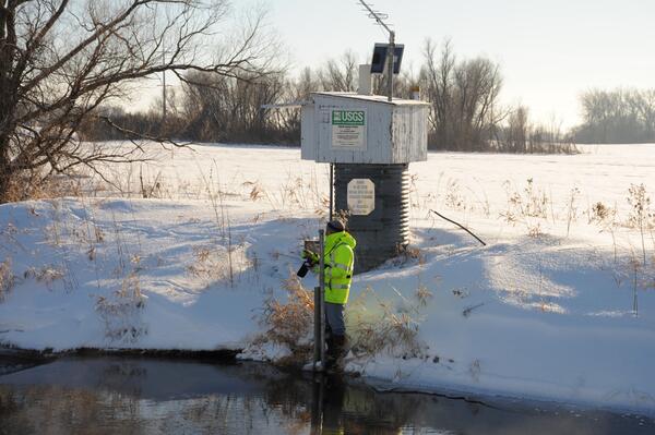
Golden hour at Streamgage 05278000 Middle Fork Crow River Near Spicer, Minnesota
Golden hour at Streamgage 05278000 Middle Fork Crow River Near Spicer, MinnesotaA hydrologic technician wearing a bright yellow coat stands in front of a USGS streamgage housing and takes a streamflow reading from the shore of a river. Soft golden lighting illuminates the scene from a sun low on the horizon.
Streamgage 05278000 Middle Fork Crow River Near Spicer, Minnesota
Golden hour at Streamgage 05278000 Middle Fork Crow River Near Spicer, Minnesota
Golden hour at Streamgage 05278000 Middle Fork Crow River Near Spicer, MinnesotaA hydrologic technician wearing a bright yellow coat stands in front of a USGS streamgage housing and takes a streamflow reading from the shore of a river. Soft golden lighting illuminates the scene from a sun low on the horizon.
Streamgage 05278000 Middle Fork Crow River Near Spicer, Minnesota

Nutrients, Mercury, and PCBs
The Lake Michigan Mass Balance Project measured and modeled concentrations of persistent contaminants in air, water sediment, and fish and bird tissues in and around Lake Michigan. This report provided an updated concentration data and load estimates for nutrients, mercury, and PCBs.
The Lake Michigan Mass Balance Project measured and modeled concentrations of persistent contaminants in air, water sediment, and fish and bird tissues in and around Lake Michigan. This report provided an updated concentration data and load estimates for nutrients, mercury, and PCBs.